At the turn of the 20th century the growth of the population and the demand for food it created had exceeded agricultural production. The Nile had to be controlled if there was going to be agricultural stability along its banks especially if more than one crop was to be grown per year. The only way to control and handle the Nile’s flow was to create a dam.
The building a dam at Aswan was first started in 1902.This became the principal means of storing water for the irrigation of the Nile valley. After attempting to increase the Dam’s height between 1907 and 1934, the dam proved to be insignificant because it was necessary to open the sluices to relieve the water pressure building up against the dam. This caused a great amount of damage downstream, flooding areas of land that were supposedly protected.
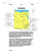
It was then decided that a second, larger more effective dam was necessary. This led to a new dam created in the 1960’s called The Aswan High Dam. This had many effects on Egyptian life, agriculture, the environment and the economy of many states surrounding the dam.. The map on page 2 shows the location of the dam. Below is a photo during construction.
The estimated cost of building the High Aswan Dam was approximately $1 billion. The Egyptians and Sudanese did not have this kind of money. There were only three countries which could afford it. They were the U.S., Britain and Russia. For political reasons, the United States and Great Britain refused to fund the project. The Egyptian government was forced to negotiate the construction and financing with the Russians. After long negotiations, the Egyptian government were left with no choice but to comply. Egypt allowed the Russian government considerable input on the dam construction. The Russians were only concerned on constructing the dam at a minimal cost. This meant that potential problems and consequences of the dam were left at a high probability.
Such a huge project has inevitably had an impact on the economic, environmental and social aspects of life in Egypt where 95% of the population lives within 12 miles of the river.
Economic Impact
There were vast economical benefits as a result of the creation of the Aswan Dam.
As the dam holds so much water behind it, a huge lake is formed (Lake Nasser). Lake Nasser is approximately 310 miles in length and, in places can reach a depth of 600ft. The electricity generated by the released water from the dam was vast ( producing 8 billion Kilowatts per hour), more than a third of the Egyptian electric consumption in an average year. As a result of this additional electric source, electricity became more available (technically and economically), contributing to industrial development. The fact that cheap electricity was available meant farmers and the local population as a whole could spend more money on improving their own businesses e.g. buying more crops, electrical pumps.
Another aspect which greatly increases the Egyptian and Sudanese income is the selling of surplus water which wasn’t needed.
On the negative side, however, a problem which went with this developing industry was that it wasn’t accompanied with any ecological awareness e.g. development of a waste water system
Lake Nasser is not just beneficial to the electrical situation but served as a great ambassador to tourism. Tourism was boosted as it was possible to travel up and down the lake all year round. The lake also created lots of opportunities for water sports ranging from wind-surfing to water skiing. This created jobs for the local community and they could charge tourists for the use of their equipment .As the Nile is now more stable, navigation on the mighty river itself has improved. It is now possible to navigate all year round rather than being seasonal. This gave another boost towards the tourist industry.
Not only did Lake Nasser contribute to the incomes of the tourist industry but, as the Nile’s flow was cut off this meant that large amounts of fish were trapped. As shown in map on the next page.
This gave the fishing industry up stream a tremendous boost. However, the decrease in fertility downstream caused by the High Dam had a catastrophic effect on marine fisheries. The average fish catch declined from nearly 35,000 tons in 1962 and 1965 to less than one fourth of this catch in 1969. 30,000 jobs were lost as a result. Hardest hit was the sardine fishery which is largely dependent on the flood season.
The construction of the dam had a direct impact on the farming industry of Egypt. One of the effects on agriculture was that crops could be grown all year round. A major reason for this was that the irrigation could be used to keep the crops – mainly rice and sugar cane -growing during the dry months. Since the fear of flooding no longer existed, farmers were able to work in the fields all year round. The High Dam created a 30% increase in the cultivable land in Egypt, and raised the water table for the Sahara as far away as Algeria. This gave farmers, on the whole, a higher annual income. They could grow enough food not just to feed their family but to sell their goods at the market, generating more money for themselves.
Not all impacts on agriculture were positive however.
Before the dam was built and the Nile flooded every year it would pick up pieces of plant life and soil called silt. This silt is dropped off on the banks of the Nile as the flood recedes, and creates excellent top soil that provides 2 or 3 crops every year. As a consequence of the silt being captured by the dam, farmers have to use more and more fertilisers every year. Farmers have been forced to use about a million tons of artificial fertilisers as a substitute for the nutrients which no-longer fill the flood plain.( see diagram below.)
Many of the smaller farmers have been forced to move out and this has left a lot of the farming area in fewer hands and so the traditional nature of farming has changed.
Another problem caused by the lack of silt relates to the brick making industry. Silt is the basic component of Egyptian bricks and production dropped by one-third between 1970 and 1980.
Environmental Impact
The Aswan High Dam has caused many effects to the environmental surroundings of the river Nile.
There has been increased salinity in the Delta soils. This increase in salinity is a result of water being left standing on the fields for long periods of time, then evaporating leaving the solid salts behind.
The Nile Delta itself is having problems due to the lack of sediment since there is no additional accumulation of sediment to keep erosion of the delta at bay so it is slowly sinking. The construction of the dam has also caused a contamination of soils and Nile water because of the developing industry. There has also been accelerated desertification because farmers are abandoning fields that no longer are cultivable and because they can’t afford the essential fertilisers to maintain their crops on the farms.
An additional important of the impact on the environment is the disruption of the local ecosystem as shown in several ways.
The salt water disrupts the animal habitat and sterilises the soil in the northern delta where the banks of the Nile are becoming badly eroded.
The pollution of the Nile by the increased fertililsers is leading to nitrification of the water, depletion of fishstocks and disruption to the freshwater ecosystem.
Another ecological consequence, is the invasion of the newly formed aquatic system of Lake Nasser by the water hyacinth.. Such weeds increase the rate of transpiration dramatically. Once established, water weeds are difficult, if not impossible to eradicate. The Egyptians have dosed their canals and irrigation drains with massive quantities of herbicides, at an unknown ecological cost, in the battle to get rid of the water hyacinth.
What else affects not only to the environment but the population surrounding Lake Nasser as a whole, is the increase in the risk of earthquakes around the huge lake. Introducing such large amounts of water in to the reservoir increased the pressure on the sediment strata and as a result, increased the probability of earthquakes in the area ( such as the one in 1981).
Despite a huge range of archaeological digs, many of the ancient monuments and their secrets are now lost forever under the waters of Lake Nasser. The impact of this loss is difficult to assess but is obviously a value judgement on behalf of the Egyptian government and President Nasser.
Social and Political Impact
The Aswan High Dam has created a variation of consequences, having an impact on the people who are in direct contact with the Nile and Lake Nasser.
The first people to be affected were the 150,000 Nubians whose homes were flooded by the formation of the great Lake Nasser. They were transferred to new settlements above the level of the lake. Many were bitter at leaving their traditional homelands and became disaffected. The cost of the relocation was over $42 million.
The Dam has not only stopped silt from travelling down to the mouth of the river but it has also stopped water snails that live in the river being swept to sea. These water snails carry a disease called Bilharzia and because the water snails are not being swept to sea the cases of Bilharzia are increasing among inhabitants of Egypt and Sudan. This is a potentially life threatening illness and many people could die as a result. This has led many medical experts to criticise the Aswan Dam.
As stated above, fertilisers must be used by farmers lower down the Nile as a substitute for nutrients. Unfortunately for many poor farmers , they could not afford these fertilisers and therefore were unable to maintain their farms. They and their families were forced to move into overpopulated cities and many remain homeless and unemployed.( see diagram below) The slums and shanty areas of Cairo stand testimony to this negative social impact of the dam.
The increase in tourism itself has transformed the traditional culture of the River Nile peoples as they are exposed to different ways of life.
When the dam was being built it was like a political football. When Egypt charged to use the Suez Canal in order to raise money for the building of the dam the United Kingdom, France and Israel invaded, such is the strategic importance of the area as a whole. Sudan, which lies upstream from the dam and in which the waters of the Blue and White Niles join at Khartoum, is demanding electricity from the Aswan HEP stations. This is causing controversy in the region. The long profile of the river illustrated below show that both Uganda and Sudan can claim ownership to the Nile waters.
Conclusion
Although the benefits to Egypt of the building of the Aswan Dam are undisputed it is the relative significance of the side effects which generate debate and controversy.
And as an old Egyptian doctor said, “We still do not understand the natural world in which we live and any attempt to harness and control nature can only result in her anger and wrath.”
Today
- the ice cap of Kilimanjaro is forecast to melt within the next 20 years as a result of global warning;
- natural floodplains are recognised as integral parts of flood defence systems once again;
- the Chinese are preparing to dam the Yangtse River to create a lake which will dwarve Lake Nasser
a critical evaluation of the impacts of building the Aswan Dam on the people of the River Nile 40 years ago has increasing relevance. The full impact of this project is yet to be felt – particularly in the ecological and political arenas. The natural world is yet to be understood and the undertaking of any new project on this scale should be very carefully considered
BIBLIOGRAPHY
Cross Unit Task source book
The Egyptian State Information Service
“Dams, People and Development: The Aswan High Dam Case “
Hussein Fahim
“Aswan High Dam” Britannica CD98 Multimedia Edition
“Nile River” Britannica CD 98 Multimedia Edition
“A Modern Lake Moeris: Wadi Rayan”
Gregory B. Baecher
www-ocean.tamu.edu/quarterdeck/Quarterdeck.1/Elsyed.html
Internet search
Google,yahoo,excite not (not all websites are known)
www-ocean.tamu.edu/quarterdeck/Quarterdeck.1/Elsyed.html