Atmospheric Processes - Depressions
Depressions are low pressure systems of the mid-latitude and are associated with the meeting of warm and cold air masses. These systems affect the British Isles in a number of different ways causing a number of impacts.
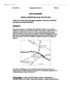
The depressions themselves form over the polar front due to the convergence of both the polar maritime, a cold air mass, and the tropical maritime, which is a warm air mass. As the warmer air meets this colder air, it rises above it due to its lower density, leading to low pressure at the surface. The system tracks west to east towards Britain on prevailing wind belt. The jet stream on the rosby waves causes a convergence of the two masses. First of all pushes the air downwards, squeezing it against the ground to create high pressure and secondly moving upwards, releasing the air allowing an area of low pressure to form. This newly formed system of high and low pressure can lead to a number of different types of weather to occur.
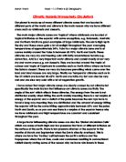
The conditions experienced vary from the beginning of the depression to the end. When depression first approaches there is a continuous fall in pressure and the visibility rapidly deteriorates with cloud formation of cirrus clouds beginning to occur. As the warm front approaches closer the depression changes direction with the southerly wind becoming more south westerly. The cirrus clouds turn to altostratus due to the warm air of the front rising over the cold air and condensing, which leads to rain to start falling. At the passage of the warm front the pressure stops falling further and stabilises, with a marked rise in the temperature and humidity. However the visibility in this front stays poor with the cloud thickening by the formation of low nimbo-stratus cloud, which often results in mist and fog. The clouds have therefore already condensed and the rainfall decreases to light drizzle or stops completely. In the rear of the warm front the conditions again change slightly as the pressure falls and the clouds change to stratus or stratocumulus. The wind also changes becoming steady from the southwest.