HYPOSTHESES:
- the stones found at the top of the “wadi” are larger then those at the bottom
- the stones found at the top of the “wadi” are more angular than those at the bottom.
- the slope at the top of the “wadi” is “v-shaped”.
- the slope at the bottom of the “wadi” is “u-shaped”.
- weathering is more common at the top, as there is more exposure.
- the angle of cross section will be smaller where the load is more angular.
- there is evidence of attrition taking place.
- the smaller the stone the more rounded it is.
- the larger the stone the more angular it is.
- there is evidence of exfoliation (onion weathering) because of weather condition in the desert.
- the gradients will be greatest in the upper course and lowest in the lower course
- interlocking spurs can be seen
- there is evidence of deposition in the lower course and near the meander.
- there is the most evidence of erosion on the stones in the lower course
- there are sign of vegetation along the course of the river
- the angle of the cross section will be smallest in the upper course and greatest in the lower course.
- the load in the lower course will be small and rounded.
- corrasion will occur more in the lower course.
- hydraulic action will ovvur more in the upper course
- A slip-off is seen at the meander.
METHODS AND TECHNIQUES:
It is very essential to be as accurate and as detailed as possible when collecting data and information. This can be done by preparing simple tables and charts earlier on, to air in the recording of the results. I noted my observations immediately, to make sure I did not forget them. It also saved a lol of time when I prepared before hand. There were four people in our group. Each one had a specific job. Missing results were copied down later on, from the person who noted them down. The required information was taken down in four different sites. Also, sketches of the meander were taken.
Choosing the sites:
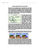
There were four main sites in which the results were taken, the upper, middle, lower and the meander of the river. Each site was carefully chosen. For the upper course, we stood where the slope was at its steepest (“v-shaped”). For the middle course, we stood where the slope wasn’t too steep or too flat, and for the lower course, we stood where the slope was as flat as possible. I chose the widest meander when measuring stones in the dry river.
Seleting the stones:
A quadrat was thrown randomly. The stones were chosen at randon from inside its “windows”.
Classifying the shape of the stones:
The rock was handed over to a specific person, who moted down the calls of the stone by comparing it with a chart for assessing their shape.
Measuring the size of the stones:
The chosen stone was placed vertically on the stone board. Its long axis was measured and noted down.
Measuring the gradients alond the “wadi”
This is also known as the long profile. One person stood in a specific place. Another person stood ten metres away, facing the first person. The clinometer was held horizontally and an immediate reading of the angle of the slope was taken.
Measuring the cross profile of the “wasi”
Two people stood ten metres away from each other, this time, across the “Wadi”. Again, the clinometer was used to measure the angle of slope. A second reading was taken, on the opposite side of the “Wadi”.