Physical effects of the flood.
Once the flood had subsided the full extent of damage both erosional and depositional could be assessed. Trees stripped of their bark were intermingled with enormous piles of boulders and occasionally interspersed was the wreckage of human habitation and property. Riverbanks had been ripped out exposing dangling roots; walls and hedges were left with gaps torn through; potholes had been gauged out of the ground leaving bewildered trout swimming in them. The river course had been altered, shortening the length by cutting through meanders. In places floodwater was forced out of the constricted riverbed and cut back from the banks were it re-entered the channel until the blocked channel was completely bypassed. Following the constrictions where the valley opened out and the gradient slackened, boulder deposits were found. The size of the individual boulders shifted depended upon the availability of boulder material and the water velocity to shift them. The largest moved was of some 350 cu. ft. found in the West Lyn, while the East Lyn produced smaller and more rounded material. Peat was eroded from the headwaters of the valley as the waters undercut the already saturated ground, causing land slips of peat up to 40 ft by 18 ft by 5 ft thick to be carried floating or rolling several hundreds of yards downstream. Gouging of the ground downstream from breaches in stonewalls resulted in pits of between 2 and 8 feet deep. Similar gouging caused the undermining of bridges on their upstream side, as waters were forced down and underneath the arches removing the drift material supporting the bridge piers. Potholes caused by trenching measured to depths of 12 ft as surface water moved downwards in sheets, entrenching itself in ruts and then rapidly down cutting. Slipping occurred in the drift deposits overlying the Devonian rock, as water ran over the impermeable layer, sweeping away up to two foot of the saturated drift and further inducing slumping. The two small reservoirs at Wool hanger and North Furzehill, both on West Lyn tributaries, burst. Suggestions that these may have been an important contribution to the flood disaster have been discredited as all the debris from the burst was deposited some 200 yards downstream with little damage to the valley below (Green, 1955).
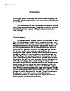
An aerial shot of the disaster zone, Lynmouth
During the period that followed the flood disaster it became noticeable that rainfall of unusual intensity caused a very rapid rise in the river levels. This immediate increase in run-off level prior to the flood was originally attributed to the effects of exhaustion of water retention within the soils. Subsequently it became evident that this situation was more permanent in that there had been an improvement in the discharge pattern of the whole catchment basin with scouring of new tributaries and widening of the channel.
Human effects.
The flood's devastating effects upon buildings and bridges occurred in two ways. Firstly, the sheer weight of the floodwaters and its load of trees and boulders pounding against the artificial structures accomplished direct battery. The main street of Lynmouth was damaged in this way, as was the bridge at Glebe House, Malmsmead, where both its piers were based on the solid Devonian rock and could stand the weight of debris and water behind. There the bridge broke at its weakest point, the junction of the span and the sides. The second way of property destruction was the undermining of structures that were built on easily erodable drift deposits. Most of the ruination of houses and bridges was due to this undermining action.
Why the flood happened.
-
Exceptionally heavy rain occurred at a time when the ground was already saturated.
- Drainage and steepness of the valleys contributed to rapid run-off. The rivers are ‘spate’ rivers where floods are commonplace.
-
The Lyn Rivers include a large area of high, wet moorland in their catchments and the rivers meet at Lynmouth, where all of the water from this large area is concentrated.
-
The rivers at Lynmouth have been ‘rejuvenated’, resulting in narrow valleys and confined channels unusual for rivers at the end of their courses.
- The bridge over the West Lyn, an immensely solid structure based on the Lynton Beds, did not give way to the waters. Instead, the area below filled with flood debris and thereafter acted as an obstacle, diverting the West Lyn and its debris load down the main street of Lynmouth. Meanwhile, the East Lyn had removed the easily erodable alluvial deposits at its bank side, undermining the cottages of Middleham and depositing them into the flow.
Conclusion.
Lynmouth was prone to floods and was most certainly ready for the 1952 flood. By examining the physical environment the inevitability of such an occurrence was very real. All that Lynmouth was waiting for was the rains, and like so many communities that live in potential risk areas, this was only a matter of time. The measures undertaken to secure the safety of the village have continued to work. The major undertakings of channel clearance and widening have ensured an adequate area for the water to travel through unhindered. Reconstruction of bridges and the removal of bank side houses have further warranted against the damming and blocking of the rivers. Early warning systems have been put into place to alert those who may be in danger. To date several warnings have been given when the river level climbed. Localised flooding has occurred around the Barbrook area but nothing in resemblance to that of 1952. Some say that Lynmouth's charm has been lost but it has emerged in a resurrected and changed form, attractive, picturesque and, hopefully, safe.
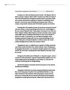
Destroyed house.
" We watched a row of cottages fold up like a pack of cards "
Ken Oxenholme (resident).
Bibliography- with many thanks to Exmoor-nationalpark.gov.uk and to bbc.co.uk/news. And tobeautiful-devon.co.uk for supplying the maps.