With reference to contrasting examples examine the ways in which the impact of tropical cyclones vary.
With reference to contrasting examples examine the ways in which the impact of tropical cyclones vary. Tropical cyclones are systems of intense low pressure. They are known for they're extreme velocity winds and their heavy torrential rainfall. Tropical cyclones tend to develop over warm seas (especially tropical where there is enough depth of warm water) in autumn when sea temperatures are the highest and they form in the trade wind belt where the surface winds warm as they blow towards the Equator. Tropical cyclones are known by different names depending on where in the world they form; hurricanes, typhoons and cyclones. Once formed they move westwards . They are another mechanism by which surplus energy is transferred away from the tropics. Tropical cyclones have caused widespread destruction and deaths. Hurricanes are the tropical cyclones of the Atlantic. In mid August 1992 hurricane Andrew formed in the middle of the Atlantic Ocean. Wind speeds of over 240 km/h along with torrential rain and a 5m tidal surge were predicted. In response to the warnings, the Florida population prepared itself for the hurricane. On the 24th of August the hurricane hit southern Florida devastating Homestead, Florida City and parts of Miami, then continued north-west across the Gulf of Mexico to strike the Louisiana coastline. Hundreds were injured and at least In all, the storm caused 15

How useful are urban models to the modern geographer and urban planners?
How useful are urban models to the modern geographer and urban planners? An urban model is a simplification of a real city. They are used to help us understand more about real cities by showing patterns or processes which in real life may be complex and difficult to identify. They are applicable to a large number of cities rather than one particular city. They are based on the idea that there are similarities between cities. Geographers use these models to try and identify and explain urban spatial patterns and variations in their structure. Where as urban planners use the models to deal with real life situations such as deciding where to place a new motorway or deciding where to build a new business park. The first urban model to be produced was by Burgess in 1924 he attempted to explain the outward expansion of the city (Chicago) and the socioeconomic groupings of it inhabitants. He did this by splitting the city into five concentric zones: the central business district, transition zone, low class housing, medium class housing and high class housing. He devised these zones by the theory that individual compete with each other for the most favourable locations within the city. This competition was founded on the market for buildings and land: those who can afford the highest prices will get the best and most favourable land. This model could be useful to modern

Road Traffic Accidents
A Guide on the Factors that are Connected with Road Accidents What is a Road Traffic Accident? (RTA) A road traffic accident is an event during which a vehicle either heads off from the road and will either end up in a ditch, or a collision with anything that can cause damage to the vehicle, including other vehicle's, telephone poles, buildings, and trees, humans or animals. Road traffic accidents (RTAs) can also be referred to as car accidents, traffic collisions, auto accidents, road accidents, personal injury collisions, motor vehicle accidents, and crashes. An estimated 1.2 million people worldwide each year are killed in some form of an RTA, and those that are injured is approximately forty times this number Causes of Road Traffic Accidents Environmental Factors Rain Rain can effect a driver's perception and produces visibility changes through its contact on headlamps, windshields, the road itself and road markings. The rain can also affect the driver's vision visibility through the windshield. The windshield wipers are never 100% effective, the splashing of the rain and the windshield wipers block vision and objects on the road. Wipers can also leave a smear on the windscreen and only clear 2/3 of the windshield from rain. When rain is combined with dirty water or slush thrown up from the road by other drivers, windshields can quickly become dirty. Water
Geography::Population Distribution of U.K.
Charles Leftwich::Geography::Population Distribution of U.K. The average population density in the UK is 244 people per square mile, compared to 2.6 for Western Sahara, for example. Out of a total population of 60,441,457, 0-14 years: 17.7% (male 5,490,592/female 5,229,691) 5-64 years: 66.5% (male 20,329,272/female 19,855,862) 65 years and over: 15.8% (male 4,063,357/female 5,472,683) This shows that the medium and main age range is within the working age gap of 15 to 65 year olds. As you can see, the percentage of people in this age band is 66.5%. This means that at the moment, we have enough contributions to the economy to allow the remaining 33.5% of the population to be catered for significantly. The industrial revolution saw masses of people moving into cities and towns. And in doing so, moving away from the countryside and rural areas. Now people are moving out of towns into the countryside, and commuter towns etc., because most people these days have access to cars, and other means of speedy transport, i.e. trains and busses. There has also been a rise since the 1950's onwards, due to the construction of large amounts of high rise buildings and as the Americans call them, "Condos," which mean there are a lot more people concentrated in one small area on top of one another, many more than before. This leads to a higher
Counter Urbanization
Counter Urbanization This report aims to proof and confirm that counter- urbanization takes place between the cities in the west - midlands and the County of Powys. The main cities concerned are, Coventry, Worcester, Hereford and the largest being Birmingham. This report will be examining the following points: > The ages of the individuals moving from the urban areas to the rural areas. > The reasons why people moving > Where these people are moving from and where they are moving to These three points will help to proof my previous statement. Counter Urbanization - Definition The definition of counter - urbanization in the simplest form means the movement of people from urban areas into rural areas. An example of this is the movement of people in the urban areas of Birmingham into the rural areas of Powys. During the past 30 years, urban growth in the industrialized countries has begun to give way to the process of counter-urbanization, which has reduced the size of conurbations. Counter-urbanization in the United Kingdom was strongest in the 1970s when the conurbations lost about 7 per cent of their population, followed by a further 2 per cent loss in the 1980s. Several factors account for this change, including rising costs in the urban centers, subsidies encouraging commercial relocation into more rural districts, improvements in transport and technology, and
What is meant by the term Urbanisation?
.) What is meant by the term Urbanisation? Urbanisation is the process in which the number of people living in cities increases compared with the number of people living in rural areas. A country is considered to be urbanised when over 50% of its population lives in urban places. In the UK the movement of people from rural to urban areas followed the industrial revolution as people were needed to work in the factories in the CBD. It took place throughout the 19th and Early 20th Centuries in Europe and North America. By 1950 most of the people in these two continents lived in urban area. However their urbanisation was relatively slow, allowing government's time to plan and provide for the needs of increasing urban populations, in Less Economically Developed Countries urbanisation serves to be a much bigger problem and it is here where the world's largest cities are. A range of economic, political, social, cultural, and environmental factors affect urbanisation. Government policies in many developing countries promote industrialisation and international capitalist economies. Urbanisation is encouraged socially and culturally through the media, and environmental factors such as the seasonality of agricultural work, may encourage urbanisation during the agricultural off-season. Urbanisation is caused by a number of factors; one example in an LEDC is that people move to the city

For my Travel and Tourism coursework I have chosen Marbella as my European destination
AO1 - Marbella Ronda is a beautiful town that lies within the Serranía de Ronda mountain range 48km away from Marbella at an altitude of 739 meters. The town is split into two different sections by a 100 meter deep gorge called El Tajo and is joined by the Puente Nuevo (which stands for New Bridge). The bridge was built in 1751 and took a total of 42 years to build; this is a key tourist attraction that brings many tourists to Ronda year in year out. Iglesia Mayor de la Encarnacion is a historical church in Marbella that was originally built in 1505, however most of the building was raised in 1712 and is now claimed to be the city's most important church which makes it popular for tourist visits. Alcazaba Wall (Marbella town's castle) and the 16th century town hall in the centre of town are two of Marbella's nicest buildings; these are opened up for visits and excursions and therefore help to attract more tourists to the area. Constitution Park, La Alameda Park and Arroyo de la Represa are three of Marbella's main local parks. Constitution Park which was once a garden of private residence is now used for concerts and plays throughout the summer whereas the Alameda Park and Arroyo de la Represa park are mainly used by the old Spanish locals and tourists to relax and talk in the quiet tropical gardens. For my Travel and Tourism coursework I have chosen Marbella as my
Britain's aging population
Britain's aging population Countries with aging populations have higher death rates. This is the case in the UK as death rates are particularly high in some of the popular retirement resorts along the south coast e.g. Brighton and Dorset. Although such services as the NHS work well in Great Britain and good doctors and medicine are keeping the elderly healthy until a much older age, this means that as the retirement age remains at sixty and people are beginning to live for longer. This is increasing the ratio of the number of people of working age (15-60\4 years) to support each person of sixty and over. As figure 3A and figure 3B show the UK to have the highest ratio against other high ratioed countries such as France. The figures show a forecast for the years to come, increasing by twenty years each time. Nearly all the way through the UK is shown to be the highest; this is due to the baby boom of the fifties and sixties. The official years of the Baby Boom Generation (1946 through 1964) saw a marked increase in the number of births in the world. Here's how the birth rate rose and fell during the baby boom years in America: 940 - 2,559,000 births per year 946 - 3,311,000 births per year 955 - 4,097,000 births per year 957 - 4,300,000 births per year 964 - 4,027,000 births per year 974 - 3,160,000 births per year There have even been books made about the baby boom:

Britain 1750-1900 - What changed?
Britain 1750-1900. What Changed? . a) Of the six categories the ones that saw most change are: Population because in 1750 the population was 11 million. 80 percent lived in the countryside and the other 20 percent lived in the urban areas. By 1900 the population was 40 million and 75 percent lived in the towns and the rest (25 percent) lived in the countryside. Transport because in 1750 you could only get on one canal and the roads being improved by turnpike trusts. In 1900 you could get on a train from anywhere to anywhere in the country you could get in a car bikes were common but the turnpike trusts and canal companies were out of business. b) Of the six categories the ones that saw the least change are: Politics because in 1750 only 5 percent could vote and they were men. Parliament made laws for everywhere in the U.K. except Ireland. And king George had a lot of power but not as much as other kings. In 1900 still only men voting but most of them. MP's come from everywhere and towns had authorities, which played a large part in peoples lives living, and working conditions improved because of this. 2. a) Between 1750 and 1900 of the six categories the one that changed the fastest was work because in the 1750's the main work was farming. But rather quickly in 1825 many people had small workshops factories had steam engines cotton had started to be used. The use of coal
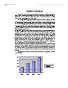
Bombay is found on the west coast of India on the coast with the Arabian sea/ Indian Ocean. Mumbai.
BOMBAY (MUMBAI) Bombay is found on the west coast of India on the coast with the Arabian sea/ Indian Ocean. Bombay is the biggest city of India, and the main city of the state of Maharashtra on the Arabian Sea. With 17,6 million inhabitants (including suburbs) Bombay is the second largest city of the world. In 1665 the British took over Bombay. This colonial period endured until the independence of India in 1947. When the first British community settled in Bombay, five of the originally seven islands where already added to each other when the tide was low. Only the two smallest Islands on the south were separated from the rest at that time. Around 1730 the British made the five islands into one. Walls of clay made it impossible for the sea to reach the lower country. Hundred years later they made a dam to connect the two southern islands with the rest of the city, nowadays the centre of Bombay still looks that way. Just like in the most cities of the third world people from all over the country came to the city to look for work in the factories. Everyday over hundreds of people arrive in Bombay with the hope to find a job in the city. The industrialization of Bombay started in the Second World War. The British build factories to make arms for the war. Thousands of new jobs were created by this kind of industry. After the independence the industrialization kept on going in a