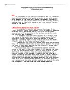
This map shows us a detailed overhead view of the river breamish. I have used to show show where about’s we will be obtaining are results from.
Method
To be able to collect the data we need accurately we are going to have to use some of the following equipment:
Callipers
Tape measure
Ruler
Ranging poles
Clinometer
Velocity
To collect the velocity and each of the sites we will be using the 2 ranging poles. We will measure out 10 meters and place the 2 ranging poles at each end of the 10 meters. The next step we will take is placing an orange about 5 meters behind the first ranging pole. We do this so that the orange can get up to speed before we take a measurement. We will be repeating this process 10 times at each of our sites, to get an accurate reading. 1 possible problem with this is that the orange could get caught or tangled up with the rocks, as it moves down the river. This has most chance of happening at the source, where the river is at its narrowest.
Width
To get an accurate measurement of the width of the river we will be using the tape measure in conjunction with the ranging poles. We will place the poles at opposite sides of the river placing them just within the bank. We will then line up the tape measure with the poles, to get an accurate reading. We will be repeating this process at all the different sites downstream.
Gradient
To get the gradient accurately we will use the clinometer. The other piece of equipment we will be using will be the ranging poles. We will have to line the clinometer with a point in line with the other ranging pole, this will ensure an accurate reading. We will have to make sure that the ranging poles are on the riverbed, and not on top of anything. If this is not done properly we could get an inaccurate reading. We will repeat this at 5 intervals downstream.
Bedload
To get an accurate reading of the bedload, we will be using the callipers. If these are used correctly they will give us an accurate reading. We will be measuring the longest side of the rock. This could cause problems with the result if this is not followed. We are going to be using a chart to determine what kind of stones we are measuring. To get an accurate reading we are going to be sampling about 20 stones, at different parts of our site. We will be repeating this process at all of our site downstream.
Depth
To accurately get a reading of the depth we will have to go in the river to use rulers. We will also be using the tape measure, so that we can mark out at which intervals we will be measuring the depth at. Once we have determined the intervals we will use the ruler to measure the depth. The only problem with this being that we might not be always be measuring from the riverbed. We will have to ensure that we are measuring from the riverbed and not from on top of stones.
I chose this graph because I wanted to compare the 4 rock categories at each of the site. This graph shows us that as the river moves downstream the rocks become more and more round. The erosion process such as abrasion, hydraulic action and corrosion causes this. These all act on the rocks and cause them to break down, and become smoother and more rounded.
If we take site 1 as an example and compare it with site 11. Site 1 is a good example of a place where most of the rocks we sampled were either angular or sub angular. With fewer round and sub round. Where as at site 11, it is the opposite there are lots more round and sub round, but few sub angular and hardly any angular. This comparison shows that as you move further and further downstream the rocks become smoother and rounder.
This could be because of the forces and erosion processes, which are acting on the rocks. The processes like hydraulic action, abrasion and corrosion, which act on the rocks and cause them to wear and break down.
The two results that don't really fit with my trend are site 7 and site 8. The reasoning behind this is that these 2 sites were tributaries. This means that they don't have the same amount of forces acting on the rocks. The tributaries aren't going to have the same velocity so the
I have decided to use a logarithmic graph to show my data because it can compare 2 or more sets of data. This graph which I have made is a graph which compare how the bankfull width and bankfull depth change as the river moves downstream. It clearly shows us that as the river gets the wider the rivers depth increases aswell.
If we were to compare the two lines we could see that they follow a similar trend. So if we look at the bankfull width from site 9 to site 10 we can see that it increases, so this means that if we look at site 9 and 10 on the depth line we will also see that it increases from site 9 to site 10. This comparison shows clearly that as the bankfull width increases or decreases, the bankfull depth should also increase or decrease.
The reasoning behind the increase in depth and width is because of the erosion. The erosion which is happening here is, lateral erosion which would make the river wider, over a period oftime. Also hydraulic action would be the main cause of the river becoming deeper.
So in conclusion I can clearly show that as the bankfull width gets wider, the bankull depth should follow the trend and become deeper.
So I can now prove show that my theory was right apart from the few minor anomalies, which have been explained. I can now prove that as the river moves downstream the rocks become rounder and smoother. Which is what my theory states that should happen.
I have decided to use this graph because of the fact that it is one constant line which doesnt break. This is easy to show how the average depth of the river changes from site 1 to site 11. This graph clearly shows us how the rivers depth changes from the shource to mouth, it gives us an idea of what is happening.
If i was to compare site 1 with site 6, the result would be clear to see. The fact that at site 1 the depth is 0.22m, where is at site 6 the depth is 0.42m. This clearly shows us how the river depth does indeed change from source to mouth. The points which dont really fit my trend are site 7 and site 8. This is because these 2 sites were tributaries of the river breamish, so i cant really count these in my trend line.
So in conclusion to my key question i can show how the rivers depth does indeed increase from source to mouth.