
Global Warming causes are divided into two groups, natural and man-made causes
Is Global Warming Real? Global warming is a biggest issue facing the world right now. It has been debated by scientists all over the world, and used by world leaders as a political tool. It’s effects on animals and on agriculture are indeed frightening, and the effects on the human population are even scarier.’ Global warming is the rising average temperature of the atmosphere near the earth's surface. This increase of the temperature may cause naturally within the earth's atmosphere or by human influences. In common usage, it refers to the warming as a result of increased releases of greenhouse gases due to human activities. There is no universal definition for global warming. There is only a common understanding of what the term references. ‘It is the world's poorest people who are hardest hit by devastating droughts, floods and other extreme weather events. This is a massive injustice - climate change is caused by the world's richest countries.’ Global Warming causes are divided into two groups, natural and man-made causes. The natural causes are created by nature, such as: 1) Large volcanic eruptions ash acts as a shield to solar radiation and causes a cooling trend in the atmosphere; 2) Changes on earth’s solar radiation level have effect on the Earth’s climate; 3) The Earth slightly wobbles as it rotates around the Sun, as a result alternatively

'Analyse the measurements of desertification'
6 (ii) 'Analyse the measurements of desertification' "Drought and desertification threaten the livelihood of over one billion people in more than 110 countries" warned general Kofi in 2001 (Kovach,2003). Desertifications definition is highly disputed but it is generally the shift of arid or semi-arid regions to desert-like conditions, which support: little vegetation, a low soil fertility and high evaporation rates (Haggett, 2001). This work will overlook how deserts are measured by a variety of different means. To measure the growth of deserts characteristics need to be obtained. By creating set indicators for deserts the spread of desertification can be gauged. Climate (Anderson,2001) is one of the larger indicators of the spread of deserts: as you can see from appendix 1B, the worlds deserts are in general located in and around the equatorial region and the tropics. Due to this they are influenced heavily by the movements of the inter-continental convergence zone (ITCZ) which generates areas of high pressure over deserts such as the Sahara desert and due to this there is little precipitation for the whole year (below 25mm) (Berrahmouni, 2001). Desert zones receive little rain during a year but when they do it is heavy and sporadic and causes much soil erosion (Sharma,1997). So by gauging precipitation levels around arid and semi-arid regions meteorologists can

How Do humans Effect The rate of Weathering
How Do Humans Affect the Rate of Weathering? There are many ways that humans affect the world. In particular the amount of pollution in today's world is catastrophic. There is so much of it that to most of us it has gone un-noticed and blows straight over our heads. Humans through all of this pollution do not always notice in the day-to-day living of the fast moving world how they are actually affecting it. Weathering processes are occurring all around us and many people simply do not notice. For example the terrible weathering on buildings, particularly the older ones, due to acid rain. Limestone, which many buildings are made out of, is affected greatly by acid rain and in cities like London where many buildings are built from this rock, we find that areas of it have been worn down by acid rain. A good example is the gargoyles on the Natural History Museum in central London. All around the building there are pieces worn and weathered by acid rain so much that some of the figures are hard to imagine what they previously looked like. Humans have affected this rate of acid rain through the huge amounts of pollutants that we dispose of every year. Cars are the most obvious and are also the most damaging problem. Every year tonnes of harmful gases are exposed from exhaust pipes of cars and into the atmosphere. The exhaust fumes from cars contain gases such as sulphur dioxide

Spider Monkey description.
Geoffroy's Spider Monkey Presented by: Spider Monkey Kingdom Animalia Phylum Chordata Class Mammalia Order Primates Family Cebidae Subfamily Atelinae I. Introduction * Spider Monkey description New world monkeys, such as the Spider monkey are more primitive than are old world monkeys. Their brains are less complex, their thumbs are not opposable and their nostrils are further apart. They have slender bodies and limbs with long narrow hands. The black-handed spider monkey has a light to medium brown body and darker limbs with the hands and feet usually black in color. Their tail is sometimes longer than their body. The Spider monkey has a prehensile tail that is muscular and tactile and is used as an extra hand. Both the underside and tip of the tail are used for climbing and grasping. When swinging by the tail, the hands are free to gather food. Both acrobatic and swift, Spider monkeys move through the trees, with one arm stride covering up to 40 feet. Spider monkeys live in evergreen rainforests, semi deciduous and mangrove forests, from Southern Mexico to Brazil. They almost never come to the ground, remaining up in the upper canopy, preferring undisturbed high forest. Spider monkeys live in medium-sized, loosely associated groups of about 30 individuals, which fragment into subgroups of varying smaller sizes and composition. Since their thumb is
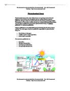
Photochemical smog is the most widely known and perhaps most serious air pollutant. It is formed in the atmosphere by the reaction between gaseous pollutants, nitrogen oxides and hydrocarbons
Photochemical Smog Photochemical smog is the most widely known and perhaps most serious air pollutant. It is formed in the atmosphere by the reaction between gaseous pollutants, nitrogen oxides and hydrocarbons in the presence of strong sunlight. These gases are from motor vehicle exhaust and commercial/industrial processes. The two types of pollutants that produce photochemical smog are primary pollutants and secondary pollutants. Primary pollutants are harmful substances put directly into the air by human activity. The main types of primary pollutants responsible for photochemical smog are: * NOx (Oxides of nitrogen) * Volatile organic compounds(VOC) * CO( Carbon monoxide) The secondary pollutants are: * Ozone(O3) * Nitrogen dioxide(NO2) * Hydrogen peroxide(H2O2) * Peroxyacetyl nitrate(PAN) These are the equations in the formation of photochemical smog:[2] NO2 (in presence if sunlight) ? NO + O. O + O2 ? O3 O3 + hydrocarbons ? aldehydes Hydrocarbons + O2 + NO2 ? lachrymatory substances (like PAN) Pollution form a coal power station Coal-fired power stations are major sources of pollution. The extensive use of coal is because there is a lot of it around. Although it produces pollutants coal is an important fuel for some considerable time to come. A coal-fired power station has three main inputs: coal, cooling water pure water to use in steam

Data logging
Data logging In computing, the process, usually automatic, of capturing and recording a sequence of values for later processing and analysis by computer. For example, the level in a water-storage tank might be automatically logged every hour over a seven-day period, so that a computer could produce an analysis of water use. Weather logging Observations can be collected not only from land stations, but also from weather ships, aircraft, and self-recording and automatic transmitting stations, such as the radiosonde. Radar may be used to map clouds and storms. Satellites have played an important role in televising pictures of global cloud distribution. As well as supplying reports for the media, the Meteorological Office in Bracknell, near London, does specialist work for industry, agriculture, and transport. Kew is the main meteorological observatory in the British Isles, but other observatories are at Eskdalemuir in the southern uplands of Scotland, Lerwick in the Shetlands, and Valentia in SW Ireland. Climatic information from British climatological reporting stations is published in the Monthly Weather Report, and periodically in tables of averages and frequencies. The British Meteorological Office's Daily Weather Report contains a detailed map of the weather over the British Isles and a less detailed map of the weather over the northern hemisphere, and the Daily

Outline the main causes of air movement. Discuss the application and limitations of the tri-cellular model.
4.1.1b The Tri-cellular Model Miss Gaunt 2. (a) Outline the main causes of air movement. One of the main causes of air movement is due to the pressure gradient force, which is the movement of air from high to low pressure areas. Between 38 degrees North and 38 degrees South of the equator there is a net surplus and towards the poles, a net deficit. Air then has to transfer from the low latitudes to high latitudes to balance the unequal heating. Coriolis and Centripetal forces also cause the movement of air. Coriolis force is the deflection of wind because of the Earths rotation, it doesn't exist at the equator but increases towards the poles. The Centripetal force causes air moving in a deflected path to increase speed towards the centre of low pressure. (b) Discuss the application and limitations of the tri-cellular model. The tri-cellular model gives us a clearer indication on the reasons behind why climates vary between the equator and the poles. However, the model still has its limits as the positioning of the overhead sun changes causing seasonal shifts in the positions of high and low pressure areas. The model is very simplified because it only indicates North-South movement of energy. It also doesn't take into account the middle latitudes of East-West air movement such as the jet streams and rossby waves that disrupt the Ferrel Cell. Rossby waves are bands of

Describe and explain the variety of landforms found in periglacial areas.
Describe and explain the variety of landforms found in periglacial areas The term periglacial literally means 'around the ice'. Periglacial regions are characterised by persistently low temperatures, but are not covered by glacial ice. The processes associated with periglacial regions, usually take place in areas where the mean annual air temperature is below 3ºC. Such areas usually experience short cool summers and long cold winters. At present, areas such as the Tundra of northern Russia, the USA and Canada, together with high mountainous regions such as the Alps, experience a periglacial climate. There are a number of different processes, which produce these periglacial landforms. These processes are frost action including shattering (wedging and splitting), heave and cracking, mass movement including solifluction, nivation and fluvial processes. Frost action is one of the most important processes in periglacial regions, which results in the physical breakdown of rocks into finer particles as water turns to ice and expands. Frost action can also cause the ground surface to expand upwards by up to 5cm per year, a process known as frost heave. In some periglacial areas, frost heave produces irregular, hummocky surfaces covered with small frost mounds. Frost action is responsible for the development of patterned ground, an array of small-scale, geometric features found
Choose three of the Emily Dickinson poems we have read. Looking at the form and language, discuss the poet's portrayal of the weather. Do the poems have any feature in common, and which do you prefer?
Emily Dickinson Coursework Siobhan Johnson 11Q Choose three of the Emily Dickinson poems we have read. Looking at the form and language, discuss the poet's portrayal of the weather. Do the poems have any feature in common, and which do you prefer? Emily Dickinson was born on the 10th December 1830 in Amherst, Massachusetts and died there on the 15th May 1886. Most of her life Emily Dickinson spent indoors, writing nearly 1,800 poems, which were discovered years after she died. Many of these poems involved the weather, which she used to describe her different moods and scene in the small town which she remained her whole life. She is widely considered one of the greatest poets in American literature. The poem 'There came a Wind' by Emily Dickinson describes the wind in many different forms. The first line 'There came a Wind like a Bugle', Bugle being a military trumpet suggests she is trying to say that the wind was like an army being led into a war. Then on the fifth line 'The Doom's electric Moccasin' there is two meanings. Moccasin, could be referred to as the shoes made by Indians of animal skin, which make the Indians walk very quietly and strike out of nowhere, rather like a storm. The other meaning to the word 'Moccasin' and the line, is lightning, which starts a storm. The Bugle also starts off military action, which shows a link. The way the trees are
Original Writing There I was, stumbling through the lashing wet, windy weather on my way back from the Kentucky Fried Chicken after purchasing a large bucket of chicken at a great expense.
Original Writing There I was, stumbling through the lashing wet, windy weather on my way back from the Kentucky Fried Chicken after purchasing a large bucket of chicken at a great expense. As I passed the local bakery, the delicious smell of freshly baked bread filled my nostrils, which was soon to be replaced by cooking oil from the fish and chips shop next door. My stomach felt sickly with the combined aromas, but lengthy queues in both stores indicated that not everyone had the same opinion as I did about the smell. I noticed a black bag in a spotlight of colourful neon lights on the side of the kerb shuffling around in the breeze like a newborn baby. Unsure of the contents, I panicked. My eyes gazed at the streetlights that glistened like a Christmas tree. They were reflected in the shop windows that displayed mouth-watering cakes, bread, groceries, a variety of continental fruits and vegetables, as well as colourful fashionable clothes. On the corner of the road, there was a brightly lit car showroom full of gleaming new Mercedes, which drew me to the window. As I gazed enviously through the window, I was startled by the deafening wail of a siren which had blue flashing lights rotating rapidly on top of a huge red vehicle that raced past me. Car horns beeped, windscreen wipers swishing back and forth, as cars accelerated above the speed limit; the drivers and


