
Spider Monkey description.
Geoffroy's Spider Monkey Presented by: Spider Monkey Kingdom Animalia Phylum Chordata Class Mammalia Order Primates Family Cebidae Subfamily Atelinae I. Introduction * Spider Monkey description New world monkeys, such as the Spider monkey are more primitive than are old world monkeys. Their brains are less complex, their thumbs are not opposable and their nostrils are further apart. They have slender bodies and limbs with long narrow hands. The black-handed spider monkey has a light to medium brown body and darker limbs with the hands and feet usually black in color. Their tail is sometimes longer than their body. The Spider monkey has a prehensile tail that is muscular and tactile and is used as an extra hand. Both the underside and tip of the tail are used for climbing and grasping. When swinging by the tail, the hands are free to gather food. Both acrobatic and swift, Spider monkeys move through the trees, with one arm stride covering up to 40 feet. Spider monkeys live in evergreen rainforests, semi deciduous and mangrove forests, from Southern Mexico to Brazil. They almost never come to the ground, remaining up in the upper canopy, preferring undisturbed high forest. Spider monkeys live in medium-sized, loosely associated groups of about 30 individuals, which fragment into subgroups of varying smaller sizes and composition. Since their thumb is
The aim of this project was to investigate what differences exist in temperatures in the local area, and to consider the effects of certain geographical aspects on these.
Introduction The aim of this project was to investigate what differences exist in temperatures in the local area, and to consider the effects of certain geographical aspects on these. This is in relation to the unit of work on Climate, Environment and People contained in the GCSE Geography syllabus, and this project uses principle ideas from this unit of study. There are many factors that affect the temperature of a region, be they on a grand scale, such as across a country or continent, or in a very small area, where a few environmental differences, such as the shelter of a building or tree, can cause a difference in temperature of one or two degrees Celsius. On a national scale, the latitude of the location will obviously have an effect, a fact clearly illustrated by the e difference in temperature between a temperate region, such as London, and a tropical rainforest town, such as Manaus in Brazil. This effect can also make a difference on a smaller scale; there is a one or two degree temperature variation between the cities of Portsmouth and London in the UK, which are only 120 km apart. Altitude is another major factor, as it is generally cooler at higher altitudes than it is at sea level, hence the appearance of snow at the top of mountains at even the warmest of latitudes. This is due to the density of the air, which decreases as the altitude increases. It is

Acid rain study
Acid Rain Task 1 - Formation and effects of acid rain a) Acid rain is a term used to describe wet forms of acid pollution that can be found in rain, snow, fog or water vapour. This type of rainfall usually has a lower pH (below 5.6 average) when acidic. It is formed when secondary pollutants formed from the oxidation of nitrogen oxides of sulphur dioxide are released into the atmosphere. These substances react with the surroundings and react with other gases in the atmosphere to form acids, which can eventually incorporate with water vapour in the clouds to form sulphuric and nitric acids. The major substances which produce acid rain is sulphur dioxide (SO2) and nitrogen oxides (NOx). Natural and human actions are responsible for the production of these pollutants. The natural processes are mainly unavoidable and include decomposition of organic matter, volcanic eruptions that release sulphur dioxide and degassing from oceanic plankton. The volcanic eruption in Philippines in 1991 resulted in a temporary decrease of global temperatures for more than two years. Acid rain has been recognised for centuries but it was not known until the 19th century that these were linked with human actions. It is known to be caused from emissions released into the atmosphere from factories burning fossil fuels such as coal and oil. In the Victorian times, coal fires released huge amounts of
WHO IS TO BLAME FOR DESERTIFICATION?
WHO IS TO BLAME FOR DESERTIFICATION? Desertification is a process by which land that was once productive becomes non-productive. Once productive is not the natural deserts, the climatic desert where rainfall is so low that no productivity can be there. But we are talking of areas where rainfall is 300- 500mm a year. This is enough to produce something. Although now, in some places rainfall is so low that no productivity can occur. The world areas worse affected by desertification are in West Africa, countries like Mauritania, Senegal and Mali, South Africa, South west of North America and many other countries. This is shown on my world map. In my case study area of Africa, the region worst affected is the Sahel in central North Africa. My map of North West Africa shows the countries affected. Desertification is happening mainly in semi- arid areas (average annual rainfall less than 600mm) bordering on deserts. It is happening in the Sahel region where the Sahara deserts margins are near the Sahel. The Sahara desert margins can turn into desert very easily. The Sahara is sometimes "pictured as a sea of sand dunes washing into the Sahel exposing farmers to waves of sand that roll in from the desert, yearly swallowing large chunks of farming land" ('Desertification' Nick Middleton). But sand only covers 1/7th of the Sahara. In the Sahel (the semi-arid area south of the Sahara
Climate in different cities around the world
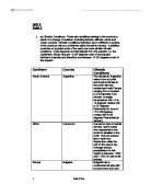
Unit 3 Task 2 . a) Climatic Conditions: These are conditions arising in the world as a result of a change of weather, including latitude, altitude, winds and ocean currents. Climatic conditions therefore vary in different countries of the world as well as sometimes within the same country. In addition, countries at opposite ends of the earth can have similar climatic conditions. It just depends on their latitude from the equator, i.e. the Caribbean, South Asia are 10-25 degrees north of the equator. Northern Australia and Mauritius are between 10-25 degrees south of the equator. Continent Country Climatic Conditions South America Argentina The climate in Argentina varies from a humid sub-tropical climate in the north with the central semi-arid Pampa ranging from a tropical to a moderately cool climate. Average temperature from -5 to 14 degrees Celsius (23 to 57 degrees Fahrenheit) in June to 17 to 29 degrees Celsius (63 to 84 degrees Fahrenheit) in January. Africa Cameroon Cameroon has a tropical climate, which varies from equatorial in the south to sahelian in the north. The wet season lies in April and September while the rest of the year is dry. Average annual precipitation for this region is between 1,000 and 1,750 mm (39 to 69 inches). Europe Bulgaria Bulgaria has a continental climate with hot summers and cold winters. Average annual precipitation is 630
Geography: Desertification.
Geography: Desertification Over-grazing is a result of too much live stock being kept on a given area of pasture resulting in the loss of edible species and the consequent encouragement of inedible species. If excessive grazing pressure continues, the loss of vegetation cover can result in soil erosion. Other common way in which human mismanagement causes desertification is over-cultivation, in which soil is exhausted by nutrient loss and erosion, the excessive clearance of vegetation, often for fuel-wood and poor management of irrigation schemes which results in salinization in soils. Over-cultivation occurs due to the shortening of periods when the land is left free from cultivation (fallow), or from the use of techniques which cause widespread loss of soil. This is usually due, as in the Sahel, to increase population pressure which increases the demand for food and so pressure on the farmers to produce more. Forests and wood land is cleared for a variety of purposes, to create agricultural and pasture land for example, but it might be that one of the most serious cause of desertification in this respect is the fuel-wood crises. The collection of fuel-wood form urban hinterlands in the Sahel, the most severely affected region, has resulted in the almost total loss of trees around major cities. We could blame the people in desertification to 3 main groups in Sahel, the
Global Warming
Global Warming The air quality of our atmosphere has been in drastic changes in the past century. Industrial revolution has cause major harm to our environment. Pollution, dumping toxic wastes into our ocean, and releasing harmful gases and sprays into the atmosphere. These are some of the cause of global warming so dangerous in the world's environment. We should take more action towards global warming before it's too late. What is Global warming? Global warming refers to an average increase in the Earth's temperature, which in turn causes changes in climate (Global). Population growth, deforestation, and pollution have increased by a large margin from twenty, forty, or even a hundred years ago. Since the Industrial Revolution, machines have changed the way life we lived. Before the Industrial Revolution, human activity released very few gases into the atmosphere, but now through population growth, fossil fuel burning, and deforestation, we are affecting the mixture of gases in the atmosphere (Global). It is imperative that we, the people, take action on our dying environment, for the future of our kids and generations to come. Unless steps are taken to stop this progression of events, and even in spite of such steps, the vast majority of the evidence shows that the Earth will continue to grow warmer, with widespread and even catastrophic results. How did we find out what
Peri-glacial areas
a) Outline the main physical processes at work in a peri-glacial area (5) b) Explain how these processes produce distinctive landforms (10) c) How do peri-glacial environments present a challenge to human activity (10) a) Outline the main physical processes at work in a peri-glacial area Currently 20% of the earth is peri-glacial; therefore we can assume that 20% of the earth's processes are peri-glacial. The dominant process is that of freeze thaw weathering, which occurs due to fluctuations in temperatures around 0°C, these fluctuations can occur periodically in seasons, or variations between day and night variations. Freeze thaw is concerned with the fact that as water freezes, it expands by 9% exerting pressures of up to 2100kg/cm3 on the rock and that most rocks can only withstand pressures up to 210kg/cm3, the splitting of the rock by freeze thaw action is known as congelifraction. Frost heave is yet another process whereby water freezes in the soil and physically pushes the surface upwards; there are three criterion which need to exist for frost heave to occur, . A sufficiently cold climate to allow freezing temperatures to penetrate below the surface 2. A supply of water from below, above or laterally into the freezing zone. 3. A soil material that is frost susceptible and is lying within the freezing zone. The heaving itself is caused by the formation of
Hurricance Katrina compared with Typhoon Tip
Tropical Storms Hurricane Katrina vs. Typhoon Tip Ben Mercer Introduction * Tropical storms are formed through a process called Tropical Storm Genesis * For TSG to occur certain factors need to be met * The ocean must be at the temperature of 26o or above for 50m depth from the surface this means areas within the trade wind belt, where warm winds heat up the surface, are more likely to experience the formation of tropical storms. Also the ocean temperatures are the highest at the start of autumn as they've been heated up for the duration of the summer meaning tropical storms are likely to occur around this time. * They usually start between 5-20o north or south of the equator and travel in a westerly direction. * After the pass onto land from the sea (landfall) they more towards the nearest poles, however away from the oceans they lose power due to the lack of a heat source and eventually become storms before being classified as depressions. * Atlantic Hurricanes are generally formed in the gulf of Mexico as the enclosed area means it can be heated up quicker and looses less heat * Tropical storms are first seen as Tropical Depression and then once they become stronger they become Tropical Storms they then go up the categories from 1 to 5. * The name differs depending on where the storm formed. If it is formed in the Atlantic then it is a hurricane, if it is formed
A comparison of Fluvial and Glacial Sediments (deposits) In the Glen Rosa area of Arran.
Geography coursework A comparison of Fluvial and Glacial Sediments (deposits) In the Glen Rosa area of Arran The aim of my investigation is to 'compare the Fluvial and Glacial sediments in the Glen Rosa area'. I will use a variety of experiments and methods to collect my results. My investigation will be based on proving these hypotheses are correct. I hope to show that: * Fluvial sediment will be generally smaller than glacial sediment. * Fluvial sediment will be more rounded than glacial sediment. To provide evidence of these hypotheses I will look at river sediment on the fluvial slip off slope and compare it with that of a glacial deposit in the form of a terminal moraine. Slip off slope; The slip off slope Terminal moraine; I will also be considering; The difference in B Axis length, Roundness, Sediment composition and Sorting. I expect the glacial deposits to be more angular than that of the fluvial deposits because the rate of erosion is different. In fluvial erosion the rocks are in constant erosion from frequently colliding (attrition) with other rock material. I would expect more edges of the rock to be rounded because the chances are they would have been knocked off. The glaciated deposits however, I would expect to be more angular because they collide less. I am going to collect a range of results which will hopefully provide evidence that my


