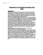
The earth is made up of several different layers
Experiment to in investigate the density of the earth Background Our planet was created about five billion year ago. At first it was just a ball of molten rock and gasses with little order to its structure. The immense amount of heat energy released at this time is still being radiated, even today, as the planet slowly cools down. As the cooling began, more dense materials such as iron (Fe) sank into the core of the Earth, while lighter silicates (Si), other oxygen (O) compounds, and water rose towards the surface. As a consequence of this distinct layers formed. The earth is made up of several different layers. The first layer is called the Crust and it can be up to 55 kms thick. The deepest mine in the world is only 3.3km deep, and nobody has ever been able to drill down further than 15km. This is not very far at all considering that the planet has a radius over 6000km. The mine does however prove that temperature increases with depth, because at the deepest point miners have had to endure temperatures well over 56°C. Everything that exists below this depth is worked out by scientists using evidence from earthquakes, volcanoes and meteorites. The crust is not a continuous layer of rocks but consists of large masses, called plates, which float on the mantle (rather like an iceberg floats in water). Continental crust is much older and much thicker than Oceanic crust. The

What Are Earthquakes?
What Are Earthquakes? Introduction: Living in England as a public we know next to nothing about earthquakes, compared to what people know about them in America, the reason they know so much about them is because they have to deal with them on a very regular basis. This article is put together to inform the public of Great Britain about what earthquakes do and how they are caused. So What Are Earthquakes: Earthquakes are, vibrations produced in the earth's crust when rocks in which elastic strain has been building up suddenly rupture, and then rebound. What Are Seismic Wave That Are Produced From Earthquakes? Seismic waves are waves of energy that are produced from the rebound of the earths crust after the rocks reach there elastic limit and rupture. There are two types of seismic waves these are P waves (primary Waves) and S Waves (Shear Waves). P Waves: P waves are longitudinal Waves. This means they cause the particles to vibrate in the direction of the shockwave. P waves are the faster of the two waves and therefore reach the epicenter of the earthquake faster than S waves. P waves also can travel through liquid and solids so this means that they can travel through any part of the earths
The Pacific Ring of fire + Formation of the continents
LCKBRI001 The Ring Of fire Brian Lockyer The Pacific Ocean throughout history has been synonymous with stories of explorers who discovered large amounts of natural mineral deposits in the form of valuable metals such as silver, gold and copper. The perimeter of the Pacific Ocean largely consists of volcanoes and large areas of land that regularly undergo vicious seismic activity. There is a unique link between the occurrences of earthquakes and the distribution of the mineral wealth around the Pacific and it is this connection between the two that is the biggest clue to one of the most puzzling questions about the Earth: How did the continents form? The 'Ring of fire' outlines the perimeter of the Pacific Ocean, it extends 40 000km from New Zealand all the way north, through the Phillipines, up to Japan and across the Aleutian trench and then south along the west coasts of North and South America.. It has been essential in helping scientists understand the formation of the continents. Until recently, it had been a common misconception amongst scientists that both oceanic and continental rocks were of the exact same nature, it was only when technological improvements enabled scientists to conduct underwater surveillance that it was discovered that there were differences
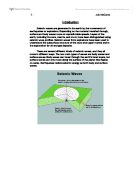
Seismic waves.
Introduction Seismic waves are generated in the earth by the movements of earthquakes or explosions. Depending on the material travelled through, surface and body waves move at unpredictable speeds. Layers of the earth, including the core, mantle, and crust, have been distinguished using seismic wave profiles. Seismic waves from explosions have been used to understand the subsurface structure of the crust and upper mantle and in the exploration for oil and gas deposits. There are several different kinds of seismic waves, and they all move in different ways. The two main types of waves are body waves and surface waves. Body waves can travel through the earth's inner layers, but surface waves can only move along the surface of the planet like ripples on water. Earthquakes radiate seismic energy as both body and surface waves. Types of Wave Body Waves P Waves The first kind of body wave is the P wave or primary wave. This is the fastest kind of seismic wave. The P wave can move through solid rock and fluids, like water or the liquid layers of the earth. It pushes and pulls the rock it moves through just like sound waves push and pull the air. The windows rattle when there is thunder because the sound waves push and pull on the window glass much like P waves push and pull on rock. Sometimes animals can hear the P waves of an earthquake. Usually we only feel the bump and

Preparation of media and reagents & aseptic technique and pure culture
Title Preparation of media and reagents & aseptic technique and pure culture Aim To prepare media and reagents and practice skills in aseptic technique Introduction Methods in molecular biology involve the use of living organisms (generally bacteria) and a wide variety of reagents, enzymes, and DNA molecules. The bacterial used in recombinant DNA techniques must be cultivated on media that allows them to grow optimally. Most bacteriological media contain rich sources of nutrients such as tryptones or peptones (which are rich sources of amino acids), yeast extract (which is a rich source of vitamins and other nutrients), and various salts. Because many of the bacterial strains used in molecules biology harbor plasmids that confer resistance to one or more antibiotics, antibiotics are commonly added to media. Similarly, other additives are often added to media so that various phenotypic changes in the organisms can be visualized by color reactions. for example, when a gene is cloned into an appropriate vector (for example pUC18), bacteria that harbor a fragment of foreign DNA can be distinguished from those that do not by adding a chromogenic substrate (X-gal) to the media. Most bacteriological media are prepared in either a liquid form (broth) or in a solid form (agars, Fig. 1). Meticulous care is taken to provide the proper concentration of nutrients, pH, and others
Describe the range of physical phenomena that are associated with volcanic hazards. What techniques may be used to mitigate against volcanic disasters?
Describe the range of physical phenomena that are associated with volcanic hazards. What techniques may be used to mitigate against volcanic disasters? Volcanic eruptions bring with them a large range of hazards. This report will describe the different range of hazards associated with volcanic activity and discus possible ways that hazards can be avoided. A volcanic eruption can, force people to leave their homes, damage sources of water, destroy homes and farms, restrict travel and kill. Pyroclastic flow is a flow of volcanic rock, and the most devastating effect of an explosive eruption. A pyroclastic eruption is one in which the great majority of activity involves fountaining or explosions. Nothing from a volcano is as blistering hot and moves with as much power and speed as a pyroclastic flow. A pyroclastic flow starts with rocks and gasses being shot up to 20 miles high into a mushroom shaped cloud. Later the column collapses and rocks and hot ash avalanche down the mountain. The rocks have the effect of running water as they it suffocates everything in its way. Large boulders are carried down the volcano as smaller rocks turn and act like a conveyor belt under them. It was a pyroclastic flow that destroyed Pompeii and killed thousands in 79AD. Pyroclastic flows are nothing like the slow predictable movement of lava. Molten rock creeps along the surface but very

Volcanic Eruptions : Monserrat
Location of Monserrat and volcano Part of a string of islands created by volcanic eruptions, Monserrat is located in the Caribbean Sea, southwest of Puerto Rico. Source: http://www.factmonster.com/atlas/country/montserrat.html Facts about Monserrat Area- 38 sq. miles Population- 11,000 Capital- Plymouth Language/s- English Ethnic groups- Black, White Religions- Protestant, Roman Catholic Highest point- Chance's Peak 3,002ft (915 m) Climate- Tropical, little daily or seasonal temperature variation. Exports- Plastic bags, hot peepers, cattle, live plants Imports- Fuels, manufactured goods, lubricants Natural Hazards- Severe hurricanes (June to November); volcanic eruptions (full scale eruptions of the Soufriere Hills volcano occurred during 1996-97). Eruptions and what happened July 1995 After 350 years of non-activity, Chances peak erupts. This is the first historical eruption. August 1995 Two-thirds of the population are evacuated to the north of the island, which is now the only safe point. April 1996 Monserrat's capital Plymouth is evacuated. June/July 1997 Due to pyroclastic flows, valleys and forests are covered in ash or lava and many buildings are destroyed by fire. Over half the island's population leave Monserrat for the neighbouring island, Antigua, or countries such as the U.S.A or the U.K. Soufriere Hill exploding Source:
Multiple Hazards in Cities: Examples from London, Mexico City and Los Angeles
Multiple Hazards in Cities: Examples from London, Mexico City and Los Angeles London London has experiences a variety of hazards for a long period of time. * Royal decree in 1306 banned burning of coal to reduce air pollution * The Great Fire of London which burned over 13 200 homes * The little ice age which caused the Thames to freeze over * The Blitz of WW2 which destroyed many homes and industry * High tides and storm surges * Smog, especially in the late 50's. London is prone to storm surges due to a combination of reasons; * Rising sea levels * Down tilting of the south of England (isostatic uplift) * Long-term subsidence. Smog has occurred as a consequence of all of the pollutants pumped into the air around London. Some of the worst were in December 1952, when; * Visibility was down to 5m * Fog had a pH of 1.6 * There were nearly 4000 deaths. To tackle this problem the following strategies were introduces; * The 1956 clean air act banned coal fires and provided financial assistance to households to convert to smokeless fuel * Houses prompted to convert to oil and gas * Legislation reducing the sulphur content of oil to 1% also helped. As a result the pollution in London dropped dramatically and continued Throughout the 80's. However the smog's returned in he 90's, but rather due to industry it was due to the large number of vehicles in
Seismology is the study of earthquakes and how the waves emitted from them travel through the earth.
Seismology is the study of earthquakes and how the waves emitted from them travel through the earth. By studying how the waves pass through the earth, seismologists can tell which materials the waves have passed through, and the nature of these materials. This has helped us to build up knowledge of the earth's internal structure and an understanding of how earthquakes happen. To understand why earthquakes happen, we need to understand what is actually happening beneath the earth's surface. Very little is known about inside the earth, because we do not have access to it as the deepest borehole is only a mere 15 kilometers down. Much of what is known comes from studying the way earthquake waves pass through the earth. The earth consists of a number of concentric layers made up of many different rock types, and substances, which stretch from the inner core to the surface crust. There are three main parts which make up the earth, these are; the crust, the mantle and the core. The Core: The center of the earth consists of a molten outer part the outer core and a solid inner part called the inner core. Both parts of the core make up an area 7000km's in diameter. The outer core is made of molten nickel and iron and the inner core of solid iron, and other radioactive and magnetic material. The Mantle: It makes up most of the structure of the earth and is approximately 2800km's
Write an account of tectonic activity, including landforms, which are associated with it.
Write an account of tectonic activity, including landforms, which are associated with it. Introduction Tectonic activity is based on the Theory first published by Alfred Wegener, which was that of the earth's crust being made up of individual plates. The crust contains several different plates all of which are but into two categories, Oceanic plates or Continental Plates. These plates make the earth's surface "move/travel". Under the earths crust is a layer of magma, the plates ride on the magma and move. Pressure builds up along the boundaries which then produce lots of instability. The types of plate boundaries found on the earths crust are conservative, diverging and convergent. Some of these plates carry ocean and the other plates carry the continent. Boundaries are named by how they meet each other therefore the plates which meet can either be ocean-ocean plates, ocean-continental plates or continental - continental plates. At the point where these boundaries are found there are different landforms associated with it. The landforms are the result of the boundaries meeting each other. Constructive and Destructive plate margins are the two more interesting boundaries to look at. These two boundaries are completely different in the processes that occur and the effects as well as the landforms that appear. Constructive Plate Boundaries Constructive plate margins are


