To examine and explain the changes in river width from source to mouth.
Objective Analysis This is now the most important part of the investigation. I shall now take all my results and graphs and sum everything up, relating to class work, textbook theories and other pieces of information. I will analyse and interpret the results that I collected, as it shall give me a better understanding of rivers and my overall results! I will now take each objective and explain it to the optimum of my ability. Objective 1 To examine and explain the changes in river width from source to mouth. From examining my compilation of results, graphs and cross sections, I get the distinct impression that as we moved from the source to mouth, the rivers width increased. By looking at the graph showing width against distance from source, I can see more precisely, where the steepest rises were. Between sites 1 and 2, the width increased nearly 1 meter. Between sites 2 and 3, there was not as quite a dramatic change. Between sites 3 and 4 was a gradual yet steep rise in width. In the vicinity of sites, 2,3 and 4 there were man made bridges. The bridge at site 2 was used for crossing the road over the river. The bridge at site 3 was used for tractors and other machinery to enter a nearby field. At site 4 there was an arched bridge, once again for tractor and farm machinery. As there were bridges involved, I can say that the velocity of the river was definitely
My aim is to investigate, using the Curley Burn River, a 4th order tributary of the River Roe drainage basin, the relationship between the changes in the river and the distance down stream. I will formulate 3 hypotheses around the river model
Downstream changes in hydraulic Geometry and bed load in the River Roe drainage basin Introduction: My aim is to investigate, using the Curley Burn River, a 4th order tributary of the River Roe drainage basin, the relationship between the changes in the river and the distance down stream. I will formulate 3 hypotheses around the river model. Planning: Hypothesis formulated: Hyp 1 -velocity will increase with distance downstream Hyp 2 -discharge will increase with distance downstream Hyp 3 - Bed load size and shape will decrease with distance down stream We worked on the River Roe and Curly Burn with the help and use of Magilligan field centre because: The centre had trained people in field work; they could provide all the proper equipment and insurance. Access permission, risk assessment and pilot study were already done by the centre Safety: Precautions taken before entering the field: * Appropriate water proof clothing had to be worn e.g. waders * A spare set of clothing had to be brought * There had to be risk assessments of the sites we were visiting * Buoyancy aid and hard hat had to be worn at all times * Open cuts had to be cover before going to the river to prevent Weil's disease * There had to be the safe use of equipment * An emergency plan had to be made and someone else not going to the field must have known where we were * A mobile phone
Dovedale on The River Dove.
Dovedale The River Dove rises on the eastern side of Axe Edge and flows almost southwards to the boundary of the Peak, forming the boundary between Derbyshire and Staffordshire for the whole of its length. The river is renowned as one of the most beautiful in the area, if not in the country, and is a famous trout-fishing river, immortalised by Izaak Walton in his book 'The Compleat Angler' - written when visiting his friend Charles Cotton at Beresford Hall near Hartington. Axe Edge is a high gritstone moor, and the river plunges steeply down to arrive at the limestone rock near Hollinsclough. Around it the hills rear up around it in weird shapes as they are the remains of ancient coral reefs. The Dove flows on through the tiny hamlet of Crowdecote and past Pilsbury and Sheen to reach Hartington and begin the section which has made it famous. Below Hartington is Beresford Dale, where the river enters the narrow gorge where Walton and Cotton fished. This is the most intimate stretch of the Dove, with the river hemmed in by steep cliffs and heavily wooded slopes which tower over it, while the stream glides lazily through turbid pools. At the two cliffs known as the Celestial Twins you enter Wolfscote Dale, which continues down to Lode Mill, about four kilometres distant. All the way you are in a fine deep valley, often flanked by steep cliffs and accompanied always by the
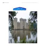
Bodiam Castle.
Bodiam castle was built between 1585 -88 in east Sussex by Sir Edward Dalyngrige. There is still a mystery on why Bodiam castle was built; many historians still don't know exactly why Bodiam castle was built. Some historians say Bodiam castle was built as a defensive feature against a possible French inversion, some say it was built as a rich old soldier's dream house or a luxurious rich mans hotel. I agree with both historians who think this way. In this essay I going to consider both reasons on what historians think Bodiam castle was built. Firstly I will consider whether Bodiam castle was built as a defensive feature against a possible French inversion. I agree with historians who think this that Bodiam castle was built as a defensive feature against a possible French invasion because of the following reasons: HUNDRED YEARS WAR The hundred years war between the French and the English was not going as planed for the English. King Richard II had lost most of his conquered land in France and several ports along the coast where been attacked and burnt by the French. This became much of a threat especially when the French attacked and temporally occupied Isle Island. The writer of the "English castles" (source B ) thinks the hundred years war was and the attacking of islands by the French was one of the reasons why Bodiam castle was built, he says; Raiders pillaged and burnt

The Afon Glaslyn, SnowdoniaCase Study of fluvial landforms and processes
The Afon Glaslyn, Snowdonia Case Study of fluvial landforms and processes All rivers aim to reach equilibrium so they are balanced and when they are in equilibrium from source to mouth a smooth curve is created called the graded long profile. However, as you can see from the diagram many rivers such as The Afon Glaslyn, do not acheive equilibrium and reach their graded long profile: Long Profile of Afon Glaslyn River with graded long profile Rivers become out of equilibrium when there is a change in base (sea) level. There can either be a positive change (rise) in the sea level or a negative change (fall) in sea level, resulting to a change in base level and a new graded long profile. Sea level changes happen because the Earth is in or out of glacial periods. Therefore sea level is changed either eustatically- a change in sea level due to a change in the amount of water locked up in ice sheets, or isostatically- when the the change in sea level is due to a change in the level of land caused by growing or retreating ice sheets. The change in base level affects the long profile of a river and as the river tries to reach its new graded profile in order to reach equilibrium there are various processes and landforms found along the river's course. By looking at The Afon Glaslyn we can see how and why these processes occur and landforms

River Mississippi
RIVER MISSISSIPPI Hydrosphere A Case Study of * River management * People interfering in the hydrosphere * A flood management scheme River Basin / Catchment area The source of the river is the eastern side of the Rocky Mountains and the Appalachian Mountains to the north. There are many hundreds of tributaries including the Red River, Missouri river and the river Ohio. The mountains form the river's watershed. From Minneapolis the river flows South-East into Iowa where it flows south as far as Davenport. At Davenport it is joined by more small tributaries. From Davenport it meanders South to St. Louis, where it is joined by the Missouri. It then flows South-East, to be joined by the Ohio. It then flows 400 km before being met by the Arkansas river. It then flows South through Louisiana, to the Gulf of Mexico, where it splits into the many distributaries of its delta. How is the Mississippi controlled ? How & why used ? Benefits Problems Levees Mounds of earth are built parallel to the river, along its banks. These contain the rising river in flood times and protect buildings along the valley on the flood plain behind. * Known & successful technology which follows nature (rivers deposit silt to build natural levees anyway) * Protect settlements * Allow land close to the river to be used for economic gain * Concrete levees are a barrier to the
What was the impact of building Harlow new town on Canon's brook? Describe the changes in the river's response to rainfall events and explain why these changes have occurred.
What was the impact of building Harlow new town on Canon's brook? Describe the changes in the river's response to rainfall events and explain why these changes have occurred. There are likely to be many effects of building a town on a brook. We can see that the most probable responses would be that more water flows into the river and the flood risk increases. However, there are likely to be many other contributing factors and other responses to these rainfall events. In this essay, I am going to examine how the changes to the response of the river occur and what these changes actually are. The river responded to rainfall very differently in three different time periods. In 1950, the peak discharge was about 1.8 cumecs. In 1950, the lag time would have been much longer due to the fact that there were no drainage systems. Water flows into the drains, and is taken straight to the nearest river which would greatly decrease the lag time. As the drainage system developed, the lag time would decrease, and this is shown as in later years the lag time is much lower. The flood risk for the area in 1950 is quite low because there is not a lot of water being discharged from the river. In 1950, the rising limb and falling limb are gentle. In the second time period, 1958-62, the peak discharge is 5.2 cumecs. We can see that the discharge has increased from the discharge of
Describe the processes by which glaciers move. (6 marks).
Describe the processes by which glaciers move. (6 marks). Glacier movement depends on whether it is warm or cold. This depends on the pressure melting point (PMP), which is when ice is on the verge of melting. An increase in pressure can increase melting and therefore movement due to lubrication. Accumulation is the inputs of the glacier system by precipitation as snow, avalanches, debris as rocks and melt water. Ablation is the outputs of the glacier system which include melt water, till-rock deposition, calving iceberg, evaporation and wind erosion. If there is more accumulation than ablation then the glacier advances due to gravity. If there is less accumulation than ablation there is more melt water, which acts as a lubricant, the glacier then moves down the valley but retreats due to climate, altitude and latitude. There are two types of glaciers, cold polar and temperate. Cold glaciers are in very cold areas where there is minimal melting, only 1-2 cm a day due to little friction because it is frozen to the bed and is on gentle slopes. The ice crystals face the direction of the movement so they can slip past each other therefore the surface of the glacier moves faster causing deep crevasses. Temperate glaciers are in areas with milder summers and steeper slopes. The base is almost the temperature at which the ice melts (PMP). As there is more friction and pressure
Using examples from a river you know, describe and account for changes that occur in the channel as you go downstream
Using examples from a river you know, describe and account for changes that occur in the channel as you go downstream The River Rhône is one of Europe's great rivers, stretching 813 kilometres from south-west Switzerland to its delta near Marseilles. For hundreds of years it was considered an unpredictable, violent river, but, through the actions of man, its character has changed completely. The Rhône begins its life on the Rhône glacier in the Swiss Alps. Unlike most rivers, the Rhône is fed by melt-water, making it unpredictable. Whilst other rivers will only flood during the spring, the Rhône theoretically can flood any time of the year. Temperature changes of only four degrees Celsius can drastically affect the discharge of the river. The river during this upstream stage has a lot of energy, since the gradient down which the river flows is unusually steep. This results in a flow that is typical of rivers in their upland course. The flow of the river can be described as very turbulent, evidenced by the eddies and whirlpools that pepper this part of the river. These are caused by the river's very irregular channel shape, which is very inefficient, due to a large wetted perimeter. The channel's irregularity is caused by the erosion of rock, which reveals different bands of hard and soft rock. This explains the existence of cataracts and waterfalls in the upper

There are three sections in a river they are called: The upper Course, The Middle Course and The Lower Course.
A river transports material through: Deposition occurs when the river starts losing energy. Heavy particles are deposited first. The light material is transported. Eventually most of the lighter material is then deposited, although sometimes not until the river reaches the mouth. The three sections of a river There are three sections in a river they are called: The upper Course, The Middle Course and The Lower Course. The upper Course, is the steepest part of land in the river. It is usually small, but flows very fast. The energy levels are high and the river cuts away at its bed. As it does it quickly deepens its valley through down cutting. This creates a steep sided V- shaped valley. Downward erosion is the dominant process. In The Middle Course, the river starts to flow slowly because it starts to transport lots of sediment, as rivers look muddy. As a river moves down its valley, a number of changes occur. The river gets wider, as more tributaries join together. * The valley sides become less steep, giving the shape of a open V. * The river begins to erode sideways, into its banks. This opens out the valley floor and a flood plain that starts to develop. * Erosion and deposition occur. * The edges of the floodplain are marked by bluffs. The lower Course, is when the valleys V shape is so wide that he valley sides have been