Find out why there is no Carboniferous Limestone visible around the Somerset area.
A2 Extended Coursework Contents Contents 1 Introduction 2 Background Information 2 Planning 7 Desktop Investigation 7 Methods of Analysis 7 Fieldtrip Planning 8 Measuring the Height of the Cliffs 8 Collecting Mudstone to determine CaCO3 8 Look at the ORS at the Quarry on the Quantocks 8 General Equipment Used for Collecting Other Data 9 Lab Work Planning 9 Possible Errors and Limitations 9 Health and Safety Issues 10 Fieldtrip Hazards 10 Lab Work Hazards 11 The Fieldtrip 12 Measuring the Height of the Cliffs 12 Collecting Mudstone to determine CaCO3 13 General Equipment Used for Collecting Other Data 14 Rock Measurements 15 Lab Work 16 Introduction 16 Method 16 Rock Sample 16 Control 17 Calcium carbonate content 17 Results 17 Rock Sample- Before 17 Rock Sample- After 18 Control- Before 18 CaCO3 Sample- After 18 Conclusion 18 Hypotheses Proved/Disproved 20 No Limestone Deposited At All 20 Limestone deposited then eroded to nothing. 21 Limestone deposited and then folded and faulted below the surface. 23 Limestone has been overlaid by other Rocks. 24 Human Activities have removed all the Limestone. 24 Combination of the Above 25 Conclusion 25 Evaluation 26 Errors and Solutions next time in the Collection of the Data 26 Improvements and Add-ons to this Investigation 28 Acknowledgements 29 Bibliography 29 Appendix

Gullet Quarry- Igneous Investigation.
Gullet Quarry- Igneous Investigation. Investigation. : To study the igneous intrusions at Gullet Quarry Aims : . To investigate whether the intrusions are of the same age. 2. To investigate whether the intrusions are the same type. 3. To investigate whether they are all from the same magma source. 4. To determine a sequence of events in the igneous section of the quarry. Plan : To carry out this investigation I will need the following equipment: hand lens, geologists hammer, crystal size card, ruler, tape measure, clinometer, penknife and a streak plate. In collecting the data to carry out this investigation I am proposing all the evidence will be uniform and will conform with the igneous work I have learnt in class. If there are any anomalous results in my data I will do my best to fit the anomalous result into my work. The evidence I am looking for is as follows:- . Crystal size. Crystal size is an important variable in determining the origin of the igneous rocks. The crystal size depends on how deep the rock was when it was formed. Finer crystals indicate that the rocks were cooled at a rapid rate i.e. near the surface of the earth. The larger the crystals are the slower the crystals were formed. Larger crystals show that the rocks were formed deep into the earth's mantle. To investigate crystal size I will need a hand lens, a crystal size card and a ruler. To
How crude oil is formed.
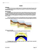
Crude Oil Introduction Crude oil is a form of non-renewable resource. It is important in daily lives and this paper will be concentrating on how it is located and extracted from the ground. I will start off with explaining what oil is and how it is formed. How oil is formed Oil was formed over millions of years from the remains of dead sea creatures. Once the remains settle down on the seabed, layers of mud and rock covers them. This causes a condition where there is no oxygen for bacteria to grow, therefore meaning that the remains cannot decay. Over the millions of years, the remains, under increasing pressure and temperature from the layers of sediments gradually turn to crude oil. As oil is not very dense, the crude oil can rise through rocks, which are permeable, meaning that liquids can pass through. Unless there is an impermeable (liquids cannot pass through) cap rock, the oil will seep up to the surface. Gas is even less dense than oil, and so often, gas is found above the crude oil. This diagram shows the separation of gas, oil and water. They are trapped between impermeable rocks, which have formed an anticline. Locating the oil Usually, crude oil is found underground in reservoirs called 'traps'. A common type of trap is an anticline. An anticline is when the layers of rock fold, causing an upwards curve. Crude oil is often found in these anticlines. The
This investigation is about workout the environment by studying sediments. I will look at the sorting of the grain sizes of the sediment to work out what the environment will look like.
Geology Coursework: Sediments and Sorting Introduction I have been set a piece of coursework. This investigation is about workout the environment by studying sediments. I will look at the sorting of the grain sizes of the sediment to work out what the environment will look like. Sorting is the number of different sized particles within sediment. I already know that if there is a wide range of grain size that the sediment is poorly sorted and that this tells me that the flow was suddenly stopped. This is like a river flowing it a lake. The stationary water in the lake suddenly stops the flow. I also know that if the grains are all of mainly one size that it is well sorted and this tells me that the flow was constant. This is like when a river is flowing down the mountain; the single grain size is dropped due to it cannot hold it (to heavy). Aim My Aim is to find how well sorted the sediments are and state what their environment must have been like. Apparatus This is a list of apparatus that, I think will produce the most fair and accurate results: * Sieve tower * Electronic scales * Five different sediment samples * Two 250 ml Beakers Method First draw a table which has nine columns and six rows. The table should look like this: Sample Starting Mass >2mm >1mm >0.5mm >0.25mm >0.125mm >0.067mm <0.067mm 2 3 4 5 The next thing to do is to collect all the

Pressures and Landuse Conflict in a Exmoor National Park.
PRESSURES AND LANDUSE CONFLICT IN A BRITISH NATIONAL PARK. EXMOOR NATIONAL PARK. THE PHYSICAL ENVIROMENT. Exmoor is situated on sedimentary rocks from the middle and lower Devonian period which was 410 - 360 million years ago. The lower Devonian period produced rocks such as sandstones and siltstones these are found along the coast to the east of Ilfracombe and stretch approximately 10 km inland. The middle Devonian rocks such as slates and limestones lie beneath the rest of Exmoor. These rocks were produced when mud or sand were deposited layer onto layer in the shallow waters of rivers, lakes or the sea. Over time these layers hardened into rocks and eventually were crushed between two crustal plates that were moving from the North and South. The pressure from these plates folded the rocks and formed a ridge and trough which runs from East to West. The sandstone that lies beneath most of Exmoor produces well drained soil, whilst areas that lie above the slates are wet, peaty and boggy. In the centre of Exmoor there is a plateau which is now open moorland, to the north the erosion of the Bristol Channel has produced cliffs and an area that is defined as a Heritage coast. To the south of the plateau grass moorland is replaced by rounded hills mostly over 300m in height which are covered in heather. This area of high ground catches the clouds from the Atlantic and receives

Experiment to determine soil texture by touch and physical analysis
________________ Introduction: The most important measure of soil is texture and size distribution of mineral particles. This is because the divided soil particles have a greater surface are per unit mass than the combine particles (Coarse particles). Therefore it can be said that a large mass of gravel or sand, will be less relevant in relation to chemical reactions than a minor amount of fine silt and clay. This is because it allows for better exposure to nutrients and the retention of moisture. Soil texture is the categorization of soil particles into three groups. Firstly, clay which is less than 0.002mm. Secondly, silt which is between 0.002 and 0.005, and third, sand which is between 0.005 and 2mm. With the use of Stoke’s law that is the governing rate of sedimentation of particles that are suspended in water. The amount of water in the soil sample will determine the percentage of moisture. With the moisture percentage, we can calculate the bulk density. In general, we can then determine the soil texture with both the feel method and the hydrometer method. Both the method and material can be found in the Sample Lab Manual on pages 15-21. Results: The soil texture allowed us to discover the true elements in the soil between our hands. The gritty feel reinforced the existence of sand. While the stickiness of the sand referred to the amount of clay, and the

Classification of Igneous rocks.
Classification of Igneous rocks Igneous Rocks are classified is several ways, and methods of classification have evolved a lot over the past 100 years. Each classification is useful for a certain purpose and reflects a particular way of looking at igneous rocks. Early in the days of geology there were few rocks described and classified. In those days each new rock described by a geologist could have shown characteristics different than the rocks that had already been described, so there was a tendency to give the new and different rock a new name. Because such factors as cooling conditions, chemical composition of the original magma, and weathering effects, there is a potential to see an endless variety of igneous rocks, and thus a classification scheme based solely on the description of the rock would eventually lead to a lot of rock names. There are various ways that could be used to classify igneous rocks... Crystal size: - Igneous rocks are formed by the crystallisation of a rock melt or magma. The crystallisation occurs during cooling, as the atoms become organised into crystals. Eventually all the crystals will grow until they meet each other, forming an interlocking three dimensional structure when crystallisation is complete. Magmas that reach the surface of the Earth in volcanoes cool quickly, forming fine-grained extrusive volcanic rocks. If the rock is cooled
To What Extent Does Limestone Give Rise To Distinctive Land Forms.
To What Extent Do Limestone Give Rise To Distinctive Land Forms Limestone is a commonly found type of rock found most my in the south of England and in Southern Africa. Limestone is a family word, as far as rocks go; this means that there are different verities, like for example; there is Chalk, Massive Limestone, Oolitic Limestone, and Tropical Limestone. All Limestone absorbs water one way or another, we use a term for this; Permeable. There are two ways Limestone is Permeable, one being Porous (like a sponge), the other being Pervious (through cracks). Limestone comes from different periods in history, Chalk from the Cretaceous period (Of or belonging to the geologic time, system of rocks, and sedimentary deposits of the third and last period of the Mesozoic Era, characterized by the development of flowering plants and ending with the sudden extinction of the dinosaurs and many other forms of life.). Chalk is porous, i.e. it has lots of little air bubbles (gaps) inside it, so when water is dripped on it, or it is dropped in water is will soak it up like a sponge. Chalk can be found in the southern parts of England, in some parts of Africa, and other places around the planet. Oolitic Limestone from the Jurassic Period (Of or belonging to the geologic time, rock series, or sedimentary deposits of the second period of the Mesozoic Era) is also a porous Limestone, found in

Maggies Rock.
I was heartbroken to leave the only home I had ever known. I had grown used to the hustle and bustle of city life. Looking out of my attic window I could see the traffic roar past like huge dragons coughing smoke and would open their jaws and roar if anyone should get in their way. Small figures like working ants going this way and that, no time to speak or even look at each other, through trying to reach their deadlines. My world, it seemed to me had all but come to an end three months earlier, when mum and dad had decided to divorce. It had been very nasty and I would often come home to mum crying alone in the house. Mum had often said that she would like to escape from the fast paced life of the city and it seemed that her wish had now been granted. We were all packed up and ready to set off for Foley Harbour, a picturesque fishing village on the South coast, where mum had acquired a small tea shop which she was going to make into a thriving business, this she said would be a new beginning. And I to make her happy just went along with it; even though all my friends and everyone I had ever known would be left behind. It seemed like an endless journey from the hectic city to the pleasant atmosphere of the country, the landscape forever changing until all their seemed to be where field after field with houses dotted about in tiny villages, there lights twinkling in the

Distinguish between abrasion and plucking
6a) Distinguish between the glacial erosion processes of abrasion and plucking. Plucking occurs high on the glacier, well into the zone of accumulation, because for plucking to occur the temperatures have to have slight fluctuations around the melting point of the ice. Plucking occurs usually at the bottom of the glacier where, because of the pressure pushing down on the ice from above, the ice is at the pressure melting point. When there is a rock with a crack in it, the melted ice fills the crack and then refreezes. The refreezing exerts a pressure on the rock and weakens it but the water also freezes to the bottom of the glacier and is pulled away. When the frozen water in the crack is pulled away so is the rock. Abrasion however can occur anywhere along the profile of the glacier. Abrasion is the sandpapering of material. Debris can be put into the glacier by many methods including plucking and the material is then dragged along the bed of the glacier. The coarse material scratches the surface and the finer material polishes the surface. The material caught in the glacier is eroded into a fine rock flour which gives glacial melt water its milky appearance. 6b) Assess the relative importance of the factors influencing rates of glacial erosion. There are several factors affecting the rates of glacial erosion including: presence of basal debris, debris size and shape,