Landform of the region
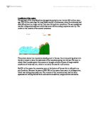
Landform of the region The geology of the long Mynd has changed dramatically over the last 920 million years ago. 920 million years ago the long Mynd was full of volcanoes, when the volcanoes had died off and were no longer active, they were formed into mountains. The surrounded sea was full of deposited sediment which had came off the eroding mountains near by. The wrekin is the remains of the ancient volcanoes. This picture shows two mountains standing next to the sea, the arrow pointing down into the sea is meant to show the sediments of the mountains going into the sea. The way, in which I feel I could explain this erosion is through millions of years of tough weather conditions of wind and rain, which is normally the case for rock erosion. By 870 million years the mountains were at the bottom of the sea this is referred to as pre-Cambrian. Between the years of 830-790 million years there was a lot of deposition, which was taking place under sea. The remains of the mountains had, had the water squeezed out leaving behind hard rocks such as sandstone, conglomerates and shales. This picture shows further eroding in the mountains and sandstone and other forms of rocks starting to develop at the bottom on the bottom of the sea. Between 790-200 million years ago the land had rose and the sea level had droped dramatically, this had meant that the sediments that had eroded

Soil is a product of its natural environment and the ways in which humans use it" Discuss
"Soil is a product of its natural environment and the ways in which humans use it" Discuss In this essay, I will be looking at soil and will be discussing the different factors which influence the soil, the different types of soil found as a result in the UK and the ways in which humans can affect the soil. Soil is a thin surface layer of the earths crust and provides the foundation for plant and animal life on land. Soil is a large, dynamic ecosystem and is made up of many different components such as; water, mineral matter, air and organic matter. The residual layer of weathered material that has accumulated over a long period of time is known as regolith. There are many different factors that can affect and influence the soil, these include; the parent material, the climate, topography, organisms and time. The parent material is the underlying rock which is eroded at different rates and supplies the minerals to the soil, and this can make a large impact on the soil. The minerals that are provided by the parent material erode at different rates and use different processes of weathering. Other impacts that the parent material has on the soil type is the soils depth, texture, permeability and the soils nutrient content, as well as this, the parent material also has an impact on the soils colour. Another large factor that can affect soil is the climate. The climate of
Determining the paleoenviroment and tectonic history of a small area (Cocklawburn Beach)
Geology Coursework Jonathan Robinson Geology Coursework: Determining the paleoenviroment and tectonic history of a small area (Cocklawburn Beach) Planning In this coursework I am going to try and find the tectonic history and paleoenviroment of an area of exposed rocks along a short section of beach in Northumberland, Cocklawburn beach is 50 metres to the south of Berwick-upon-tweed and can be found on OS map sheet 75. The general geology of the area is that it is mostly carboniferous limestone with layers of sandstone, shale and coal existing between the layers of limestone. I know this from previous experience in the area, as I have completed a sedimentary log for another section of rock in the same area, at Cullernose Point For the paleoenviroment I am going to look at and analyse the rock type.. I will check the rocks for structures and fossils as they can be used to determine the absolute age of the rocks and they can also be used to check if the rocks have been shifted or if they have been moved upside down. The first thing that I shall investigate with respect to paleoenviroment is the relative age of the rocks. For the tectonic history I shall investigate the Dip and Strike of the rocks, as this will show the attitude of the rocks relative to the horizon and it will show if any tectonic activity has shifted the rocks, and also if there are any major igneous

Construct two Graphic Log Sections, one on the eastern exposure (ST 3375 6645) and one at the western exposure (ST 3245 6605) of the Carboniferous Limestones and volcanic rock exposed in the low, coastal cliffs - compare the two.
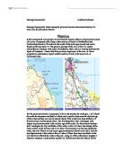
Contents -Introduction............1 -Data Collection............2 -Log Graphs............2a -Analysis (Location 1) ............3 -Analysis (Location 2) ............4 -Conclusion............8 -Evaluation............10 -Bibliography............8 Geology Bath and Bristol Coursework Introduction From the 1st-4th July we studied a geological area based around parts of Somerset, around Bath and Bristol areas. One specific site that we studied was Sand Bay, north of Weston-Super-Mere, (ST 3305 6596, which is located on the map above. The purpose of this investigation was to construct two Graphic Log Sections, one on the eastern exposure (ST 3375 6645) and one at the western exposure (ST 3245 6605) of the Carboniferous Limestones and volcanic rock exposed in the low, coastal cliffs. Then to compare the two graphic logs (similarities and differences) and interpret the geological condtions that led to the formation of the sequences observed. In South Wales and the South-West of England in the Lower Carboniferous times, several hundreds of metres of limestone and calcareous mudstones passed southwards into a deformed sequence. A shallow south sea in the north bordered a deeper marine area to the south that revealed limited supplies of course sediment, in which was some volcanic activity. Data Collection We collected data from two locations. We had to predict if there was

Barr Beacon Quarry
Barr Beacon Quarry Introduction Barr Beacon Quarry is a disused quarry which hasn't been worked since the 1920's, and was quarried for sandstone required for local buildings. The quarry consists of 2 different rocks laid down horizontally on top of one another. Plan I aim to find out the environments of deposition of each rock, for example desert conditions, shallow marine water, deep marine water, and river conditions. Hypothesis I think that both rocks had different deposition environments and one rock water deposited in water and one on land. Method . I first studied a photograph of the quarry to select the areas that I am going to study in closer detail. 2. I will draw sketches of the whole quarry and of smaller section in greater detail in order to obtain a greater knowledge of the rock. 3. I will describe the rocks in multiple places using sketches to aid me. 4. I will collect samples of each rock that I will sieve in the laboratory. 5. I will describe the sedimentary structures and textures present and will use sketches to help. 6. I will conduct a pebble survey on the scree slope at the base of the cliff by walking down it backwards and collecting the stone in front of me, measuring its size and shape and then repeating that until I have 20 samples. 7. I will conduct an analysis of the pebble layer in order to determine its environment of

Rock types.
ROCK types * There are 3 types of rocks. *Igneous *Sedimentary *Metamorphic Igneous * Formed when molten magma from mantle is pushed out through the earth's crust often through volcanoes forming hard and layered rocks with speckled appearance. These contains minerals randomly arranged in large and interlocking crystals as magma cools slowly inside the earth's crust. The cooling produces rocks that always contain crystals. * 2 types: intrusive and extrusive rocks *Intrusive rocks formed when molten magma from mantle cools slowly (underground) inside the earth's crust forming rocks with large crystals such as that of granite's. Granite is a very hard and decorative stone ideal for steps and buildings. *Extrusive rocks formed when molten magma from mantle cools quickly above the earth's crust forming rocks with small crystals usually dark in colour such as that of basalt's. Sedimentary * formed from layers of sediments laid deep down inside lakes or seas over millions of years. The layers are cemented together by salt crystals. * Made up from fragments of older rocks that have been weathered or may have formed from the remains of living organisms. * Formed in layers and these may give additional evidence about the conditions they were formed and may show evidence on the wave ripples on their surface. S. Rocks with large and coarse-grained particles were

To see how fast limestone dissolves in an acid solution.
Surface Area Vicky Bishop Aim: To see how fast limestone dissolves in an acid solution. Prediction: I predict that that 1 solid limestone weighing 3g will take longer to dissolve than powdered limestone weighing 3g. I predict this because the more surface area there is exposed to the hydrochloric acid the faster reaction will take place, therefore it will dissolve quicker. Apparatus: Glass beaker Cork Hydrochloric acid Calcium Carbonate Glass bowl Stopwatch Method: ) Collect 1 solid piece, 2 solid pieces, 3 solid pieces and powdered limestone all weighing 3g each. 2) Place 50 ml of 2m hydrochloric acid in a beaker and add the 1 solid piece of limestone. 3) Put the cork in top of the beaker and start the stopwatch. 4) Time how long it takes for the limestone to stop bubbling and put the results in your table. 5) Repeat this with two pieces of limestone, three pieces and powdered limestone. Diagram Fair test: To make sure that this experiment is a fair test consider the following: * Make sure there is the same amount of Hydrochloric acid, this could affect the rate of reaction. * Make sure there is the limestone's weigh the same, if the weight is not the same the reaction time won't be accurate. Key Factor: The key factor in my experiment is the form of the limestone ranging from 1 solid piece to powder both weighing 3g. Results: Limestone Test

Describe the characteristics of chalk and the land forms typical of chalk areas
Describe the characteristics of chalk and the landforms typical of chalk areas Chalk is a soft white or whitish form of limestone, composed of the remains of small marine organisms. It formed after the shells and skeletons of these organisms were deposited in a thick layer on the sea bottom. Chemically, chalk is almost pure calcium carbonate with traces of other minerals. It ranges in hardness and texture from very soft porous varieties to harder close-grained types. Chalk is particularly common in strata of the Cretaceous period (Latin creta, "chalk"). Large deposits are found in Iowa, Texas, and Arkansas in the United States, and in the British Isles. Cretaceous chalk is exposed in the White Cliffs of Dover on either side of the English Channel. Chalk is a type of limestone that does not develop karst scenery. However calcium carbonate levels in chalk streams have been examined demonstrating that carbonation occurs at a faster rate than in some other limestones, due to this the rock structure is not strong enough to support the formation of underground tunnels and caves. This is the reason why distinctive rolling hills and vales are common in chalk scenery areas. Chalk scenery is also closely associated with the development of escarpments or cuestas which have steep scarp slopes and gentle dip slopes. However these features are more a product of erosion than of weathering.

Earth Materials
EARTH MATERIALS Revision Notes Limestone (Ca C0() or Calcium Carbonate. Found as CHALK, CALCITE OR MARBLE. Uses of Limestone * Neutralising acid in Lakes and soil * Cement = heated Limestone and clay. (Clay contains aluminium) * Glass = Limestone, sand and soda melted Turning Limestone to Slaked Lime Limestone Quicklime Quicklime + water slaked lime The Rock Cycle Rock Types * Igneous - * Intrusive Igneous- cools slowly and forms large crystals e.g. Graphite, Gemstone * Extrusive Igneous- cools quickly and forms small crystals e.g. Basalt Sedimentary Formed from layers of sediment on top of each other. * Sediment layers are laid down in lakes or seas * Get buried further which squeezes out the water * Salt crystallises & cements particles together e.g. Sandstone If they have: - * Ripple marks - formed by waves * Discontinuous Deposition - gap in the fossil record layer could have been eroded. * Size of Particles - smaller particles take longer to settle. So clay or slate tells you water was quiet. Bigger stuff like pebbles were dumped by fast flowing water. * Rocks are found: Tilted, folded, fractured or upside down. This shows earth is unstable. Metamorphic Rocks pushed deep underground where they are compressed and heated. They don't melt and may change overtime. E.g. Slate to Mudstone and clay and Marble to

The social and economic advantages and disadvantages of limestone quarrying and it's use
The social and economic advantages and disadvantages of limestone quarrying and it's use Limestone is one of the UK's main produces and due to the hills and mountains which are made almost solely from limestone the UK quarrying industry is one of the most successful and consistent in the world. Limestone, and its products quicklime and slacked lime have, in recent years become some of the most invaluable natural resources available to today's manufacturing market. Not only are they used in many building materials such as cement, road ballast, or for sculptures, but also they have become a common additive to many more obscure or unexpected products, for example it is used in glass; as a thickener in many fabrics; in make-up and even bread. The fact is that the demand for limestone has become so great that the UK limestone production currently stands at about 2.5 million tonnes a year. A figure that is set to rise within the next five years, following the recent government spending policy. This policy has outlined plans to put £180 billion into improving roads, hospitals and schools, to all of which limestone will be a necessity. However there is only so much limestone you can take out of the hills, mountains and idyllic countryside's of Britain before you cause irreversible damage and disfigurement to the landscape. Many of the current and planned quarries stand upon