Wind is an important agent of Deposition and transportation. It's role as an Eroder remains questionable.
Wind is an important agent of Deposition and transportation. It's role as an Eroder remains questionable. No deserts are completely rainless although parts of the Libyan and Chilean deserts approach complete aridity. In such places erosion is extremely slow, although occasional showers can have sudden catastrophic effects. Trujillo in Peru received only 1.4 inches of rain between 1918 and 1925, but during March 1925 it received 15.5 inches, of which 8.9 inches fell in the three days 7-9 March. Such events apart, the present work of landscape development are controlled by the wind. (Outside the true deserts, vegetation prevents wind from being a significant agent or erosion), although it can carry enormous quantities of dust far beyond the deserts and can move sand and dust into characteristic depositional forms. It is certain that wind cannot be responsible for most of the eroded landforms of present day deserts, and it is also certain that many of the landscape features of the African and Asian deserts were produced in times of wetter climate. In the Sahara, for instance, there are numerous old lakebeds, which have been dry for a great length of time. From mountains like the Ahaggar radiate systems of valleys which could have been cut only by running water, but which are now completely dry and choked by invading sand-dunes. There is considerable biological evidence of
What Really Happened at Pompeii on 24th August AD79?
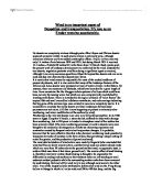
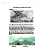
What Really Happened at Pompeii on 24th August AD79? Introduction On 24th August AD79, Mount Vesuvius, a large volcano overlooking the Bay of Naples, erupted. It is famous for the way that it destroyed the Roman town of Pompeii, and in doing so, preserved the agony of Pompeii's unfortunate inhabitants. This is shown above in this 17th century sketch showing the Vesuvius erupting. The fact that this sketch was drawn almost 2000 years after the eruption is typical of pictures and accounts of the eruption, as there is only one surviving first-hand account of the eruption, coming from Pliny the Younger, who was living with his uncle, Pliny the Elder, who was the admiral of the Roman Fleet at Misenum, a town at the North side of the Bay of Naples, the other side to Pompeii which was further south. Despite Pliny the Younger's first hand account of the eruption, there are many different theories as to what killed the people of Pompeii. Using various different sources, in this essay I aim to investigate what really destroyed Pompeii and killed the people of the town. Monte Somma Mount Vesuvius This picture shows the view of Mount Vesuvius from Naples. This is roughly the view that Pliny the Younger would have got when viewing the Vesuvius erupting. From the view in the picture above, Pompeii would be on the other side of the mountain. Monte
Investigate the relationship between the solid geology and the physical landscape from Ingleton to Thornton Force.
To investigate the relationship between the solid geology and the physical landscape from Ingleton to Thornton Force. Aim: To interpret the geology/landscape relationship. Objectives: To explore and investigate the routes between Ingleton and Thornton Force; To measure and record features of bedding, jointing and dip strike; Look closely at rocks and the different vegetation. The Ingleton area is located in the Western Yorkshire Dales and the main feature of the region is the Askrigg Block which is immediately North East of Ingleton. Resting on this block is the 200m thick, almost horizontal Great Scar Limestone of Lower Carboniferous age. Just to the North of Ingleton, the floors of the main dales cut down through the limestone to reveal tightly folded sediments of the older Lower Palaeozoic rocks which form the block itself. These inliers are stopped to the Southwest by the Craven Faults which trend Northwest to Southeast and have substantial downthrows on their southern side. South of the faults exposures in the Craven Lowlands are not so abundant although around Ingleton the presence of the productive Coal Measures and some Red Beds suggest the stratigraphic level reached is Upper Palaeozoic. This area has a long and complex tectonic history. It was established in Lower Carboniferous times and it marks the facies boundary between clean shelf limestone in the

How limestone formed.
How limestone formed? Most limestones in our part of the world formed in shallow seas that covered our area hundreds of millions of years ago. Other names for limestone We use the scientific name "limestone" for this rock, but it is also known by many other names: When limestone is crushed into gravel and used for building roads or making concrete, it's often called an aggregate. Here are some ways to classify limestone (by grouping it with similar types of rocks): Geologists have a catch-all term that includes both limestone and dolostone. They call them carbonate rocks. Limestone is a sedimentary rock. How to recognize limestone Limestone is mostly light to dark gray in color. Its grains can be mud-sized, so that the rock looks dull, or they can be sand-sized or larger bits of broken shell or other limey material. You can scratch limestone into white powder with a nail or knife. (See more about the scratch test.) Limestone is made mostly of the mineral calcite, so it bubbles gently when you put a drop of white vinegar on it. Acid Test This simple test helps you tell rocks that are made of calcite from similar rocks made of other minerals. All you need is some white vinegar. (If your parents or teacher can get it, some weak hydrochloric acid will give you more dramatic results.) Put a large drop of vinegar (or a small drop of acid)
The Earths Crust.
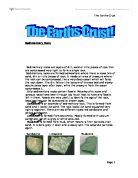
Sedimentary Rock Sedimentary rocks are layers of dirt, sand or little pieces of rock that are compressed very tight to form a single rock. Sedimentary rocks are formed somewhere where there is loose bits of sand, dirt or little pieces of rock. It needs an area of pressure where the rock can be compressed, like a very deep ocean which will force the rock down. The dirt falls on the bottom of the sea bed and slowly accumulates layer after layer, while the pressure from the ocean compresses it. Only sedimentary rocks contain fossils. Metamorphic rocks and igneous rocks have been through too much heat to have any fossils left in them. Fossils are very useful to identify the age of the rock, because they can be compared to known ages. Sandstone is an example of sedimentary rock. This is formed from sand and it looks like sand. The rock looks like sand squashed very tightly together. There are two different types red sandstone and yellow sandstone. Limestone is formed from sea shells. Mostly formed with calcium carbonate, which is grey or white coloured. Mudstone is formed from mud, which means is finer particles than sand. It is dark grey in color and is easily split into separate particles again. Metamorphic Rock The first type of rock is metamorphic. This is caused by the action of heat and pressure on sedimentary rocks over long periods of time. When the earth moves

'I think that sedimentary stones will be more affected by weathering than igneous stones.' - discuss
Page 1 H.Crawford 5/7/2007 Introduction Hypothesis: 'I think that sedimentary stones will be more affected by weathering than igneous stones.' Whilst this is what I setting out to explore and hopefully prove, I also hope to prove that the front side of the gravestones will, in general, be less weathered than the backs of the graves. I think this because most people want the front side of their grave to be less weathered and so they design the grave so that the front side will be less affected by weathering (e.g. by facing the grave east, because most of England's weather comes from the West with the North Atlantic Drift.) Pilot Study: There are many reasons for my pilot study, the main one being that I wanted to check that everything worked. This included: - To see if there were enough stones of each type, for without enough stones of each type I would have been forced to change my hypothesis for the sample size would not have been large enough for it to have been conclusive. Fortunately there were enough. - Furthermore to see if there were enough stones from different dates; or, more to the point, to check there were enough stones of the two different types with similar ages; which there were just about, although I did notice that there seemed considerably more sedimentary stones in the 19th Century than in the 20th. I researched this on the web and

The aim of this report is to define the geological evolution of the area around Stirling University and the Bridge of Allan.
Background: Introduction This report is produced in conjunction with the University of Stirling Environmental Science course 36E3. The aim of this report is to define the geological evolution of the area around Stirling University and the Bridge of Allan. In order that this be fully understood and correctly researched, a look at the bigger picture of Scottish geological evolution has been necessary as well as looking at the geology of the local area in closer detail.The geographical area covered by this report is bounded by OS co-ordinates: Southwest: 278000,695000 Northeast: 283000, 699000 Figure 1.0 shows this area in detail, using a 1:50,000 Ordinance Survey Map Extract. To enable us to fully understand the geology of the area, site visits were made to three locations within the bounded area of the report. Site 1: Wolf's Hole Quarry (Fig 2.0) NGR NS 7896 9808 Site 2: Hermitage Woods (Fig 3.0 NGR NS 8120 9681 Site 3: Hermitage Woods (Fig 3.0) NGR NS 8115 9676 (Fig 1.0) (Fig 2.0) (Fig 3.0) Geological History of Area: History 'Stirling area sits astride a major boundary between two blocks, brought together between 450 and 420 million years ago. The highlands and Lowlands are separated by the near vertical Highland Boundary Fault, a large fracture that penetrates deep into the earth's crust separating different crustal blocks.' (British Geological
Congo volcano: The facts
Congo volcano: The facts Mount Nyiragongo in the Democratic Republic of Congo is one of Africa's most active volcanoes. The volcano, one of eight along the borders of Rwanda, the Democratic Republic of Congo and Uganda, has a long history of activity. Nyiragongo was last active in 1994, when a lava lake reappeared in its summit crater. The latest eruption is more serious. Lava from Nyiragongo can travel at 60 kilometres per hour (40 miles per hour) and there are concerns that lava reaching a nearby lake could do further damage. Bill Evans of the US Geological Survey said lava could react with gas in the lake, with catastrophic consequences. "A hot lava flow flowing down into the deep waters of the lake could trigger this gas to come out very quickly," he told the BBC. "The gas is composed of carbon dioxide and methane; so it would come up and create a suffocating and yet flammable cloud that could engulf communities living around the lake." There is no record of such an event at Lake Kivu in the past. However, in 1986, Lake Nyos in Cameroon released a cloud of gas, which killed more than 1,700 people. Nyiragongo, and nearby Nyamuragira, are the two active volcanoes among the eight volcanoes in Rwanda, the Democratic Republic of Congo and Uganda. Both are in the Virunga mountain range, which straddles the border with Rwanda. The pair is responsible for nearly

Malham a quiet village in the Yorkshire dales.
Malham a quiet village in the Yorkshire dales. Malham is a national park in the Yorkshire dales, It is well known for its limestone features such as Malham cove witch is over three hundred ft high, The cove has a limestone pavement which has very deep gaps between them. At the top of the cove there is the pavement which is a group of blocks these are called Clint's and the gaps between them are called Grykes. [Diagrams] Also Malham has got a number of waterfalls there is one in Janet's Foss and one in Gordale scar these are the diagrams for Gordale scar and Janet's Foss. [Diagrams] Malham village has a number of attractions and conveniences like B&Bs such as Beck hall, Dale house and the Buck inn (which is a Pub and Hotel). They have campsites for example there is one at the rear of the Townhead barn. Malham has a few Ca?fes which has a very good value for meals and drinks they are called Olde Barn Cafe and The buck inn but there are a few more with hotels and campsites attached to them. Malham is a very quiet place which gets a lot of visitors at weekends mostly walkers and rock climbers who climb up Malham cove which is over 300 ft high. It is very dangerous because at the edge its is very unstable because of visitors walking to the edge it is getting weaker each time and soon it would be ready to collapse. With the visitors walking so much over each block on the

The Factors that form soil
The Factors that form soil Soil is initially the build up of unconsolidated material this material is known as regolith. The regolith may be derived from either weathering of bedrock or from material that has been transported and deposited. This may consist of alluvium, moraine and volcanic ash or lava. The second stage of soil formation is when something called true soil or topsoil results from the addition of water, gases, biota and decayed organic matter. Pedologists (People who study soils) have identified five main factors that contributed to the formation of soil they are all connected and can form certain types of soil. One of the main factors that is involved in the creation of soil is parent material. As I said early this is where soil develops from an underlying rock. The rock type usually makes a large difference to the soils colour, depth, texture, drainage and mineral content (nutrients) thus resulting in a difference of different soil qualities. Another one of the five main factors is the climate in which the soil resides. Climate determines the type of soil at a global scale. The distribution of world soil types corresponds closely to patterns of climate and vegetation. This is because climate affects the rate of weathering to the parent rock. With break down of bedrock being faster within hot humid environments. Climate also affects the amount of humus in