
Cholera - its global impact
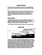
Cholera Cholera is an infectious disease caused by the bacterium Vibrio cholera, which usually spreads through contaminated water. It affects the absorption of water in the small intestine and in severe cases produces severe diarrhoea. The most dangerous aspect of Cholera is the immense loss of fluid that can occur within a few days. Without treatment within 24 hours of developing the disease, the loss of fluid can be fatal. Many cases, such as those in Zimbabwe, require hospitalisation of infected people so that fluids can be administered straight into the bloodstream with the use of a drip. Cholera bacteria occur naturally in coastal waters, where they attach to tiny crustaceans called Copepods. The Cholera bacteria travel with the Copepods, spreading worldwide as the crustaceans follow their food sources, which are certain types of algae and plankton. These grow rapidly when the water temperatures rise and algae growth is further increased by the urea found in sewage and agricultural runoff. Therefore most Cholera outbreaks occur in spring and autumn when ocean surface temperatures and algae blooms are at their highest. More algae mean more Copepods, and more Copepods mean more Cholera bacteria. The map on the left shows that the areas that Cholera is discovered in are situated below the Brandt line. This is because these areas are surrounded by warm oceans where the

The number of fatalities that result from volcanic and seismic natural hazards is related to the level of development in the country in which they occur. Discuss.
The number of fatalities that result from volcanic and seismic natural hazards is related to the level of development in the country in which they occur. Discuss. A natural hazard is an event, linked to the physical environment, which is considered to have a negative effect on humans. The event is also seen to be unpreventable by humans. However, an event such as a volcanic eruption that has no effect on human beings is considered a natural phenomenon rather than a natural hazard. It is the presence of humans, in an area that such an event occurs, that allows it to be termed a hazard. Although humans cannot prevent these occurrences, they have a role to play in the event's extremity as a natural hazard. For example, volcanic eruptions have been present throughout history, but it is not until settlements are built on the rich soils they form that they become a hazard. This essay I will evaluate the extent to which the level of development in a country affects the number of fatalities caused by volcanic and seismic natural hazards. A volcanic natural hazard is a volcanic eruption. Volcanoes are formed at convergent and divergent plate boundaries and also at hot spots. At convergent plate boundaries eruptions tend to be from a vent, as oceanic crust is forced beneath another plate, the extremities of heat and pressure leads to the partial melting of the crust which is being
Temperature Inversions.
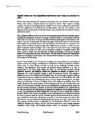
Temperature Inversions Normally, the air near the ground is warmer than the air at higher altitude. An inversion is the reverse situation--colder air at ground level than higher up. Cold air is heavier than warm air. Thus once an inversion forms, the air is very stable. Mixing that would normally occur by the rising of warm air is inhibited. Consequently pollutants such as carbon monoxide, sulphur compounds and ice fog remain trapped near the ground when there is an inversion. Types of Inversions The stability and mixing of air near the surface is controlled to a great degree by the presence of temperature inversions in the lower atmosphere. These inversions typically are very extensive, blanketing entire cities or regions. In each case, warm air is produced over a layer of cooler air in contact with the surface. There are basically four types of temperature inversions, each are explained below. Marine Inversions If you live near a coastline, you have probably experienced a marine inversion layer. Near cool oceans, such as in the western U.S. and Western Europe, a marine inversion can turn a hot summer day at the beach into a cool, foggy, overcast shiver. The ocean is typically quite cool compared with the land, particularly at middle latitudes where the heating by sunlight is not strong. Air sitting over cold water also tends to be cool. Moreover, a great deal of

Hengistbury Head is located in the south of England and has many prevention processes to prevent cliff erosion such as groynes, gabions and revetments.
HENGISTBURY HEAD COURSEWORK INTRODUCTION Hengistbury Head is located in the south of England and has many prevention processes to prevent cliff erosion such as groynes, gabions and revetments. GROYNES: wooden or stone structures on a beach, built at right angles to the shore in order to trap sand and shingle moving by longshore drift. GABIONS: small boulders contained inside metal cages, placed at the foot of the cliff or along a beach to protect them from further erosion. REVETMENTS: Large boulders placed at the foot of the cliff, used to protect a cliff against further erosion by waves. THE AIM OF THE PROJECT The main aim of the project at Hengistbury head is to investigate the management of Hengistbury Head by doing investigations on the physical and natural changes in the surroundings. We are also investigating the erosion and damage of the beach and cliffs and investigating what is being done to prevent this. On the first day of the project at Hengistbury Head, we have to investigate the physical and natural changes to the beach and cliff landscape. We have to investigate the usage of the land at Hengistbury Head, and mention all the physical features and coastal defences that are present at Hengistbury Head. We must also note down all the human features present at the location such as management, archaeological sites, footpaths, car parks and cafes. We must also
Explain where and why depositional landforms occur along the course of a river.
Explain where and why depositional landforms occur along the course of a river. Rivers have three courses. The course is the journey the river makes to reach the sea. Rivers never have a straight course from source to mouth. Their course is always irregular. Along this course depositional landforms can occur. Landforms can be formed from the deposition of weathered and eroded surface materials. On occasion, these deposits can be compressed, altered by pressure, heat and chemical processes to become sedimentary rocks. This includes landforms with some of the following geomorphic features: beaches, deltas, floodplains, and glacial moraines. The upper course is found in the mountains and hills where the river rises from its source and often waterfalls and rapids are also found in this course. The river is usually fast flowing in the upper course; also there are lots of stones and boulders for the water to flow over. Furthermore, the river starts as a stream in the upper course and flows through valleys. The middle course, however, is where the river starts to become wider and deeper. The land, which the river flows over, is becoming flatter and this is where the river starts to meander or bend in the middle course. The lower course is where the river becomes its widest and deepest. This course is found closest to the sea where the river has its mouth. The flat area of land by

Discuss the view that poverty is the real killer in earthquake disasters
Discuss the view that poverty is the real killer in earthquake disasters. (40 marks) Seismic events prove that it is a problematic for the world's population and produce devastating effects on the lives of everyone involved. However it is often said that LEDCs suffer much more from the effects of earthquakes than MEDCs. Whilst this is a generalisation it is probably true, at least in terms of the human cost. Poverty is the condition of lacking basic human needs such as nutrition, clean water, health care, clothing, and shelter because of the inability to afford them. There are several levels of poverty from an individual to national level and earthquake disasters impact at all levels. The 2010 Haiti earthquake struck in the most densely populated area of the country, As More than 78% per cent of Haitian residents live in poverty and Haiti is the poorest country in the Western Hemisphere the buildings in Port-Au-Prince and other areas of Haiti were in very poor condition in general and were not designed or constructed to be earthquake resistant. The primary earthquake hazard directly responsible for mortality is surface seismic waves which cause ground shaking. This poses a huge hazard as buildings and other structures collapse, killing or injuring their occupants. This was the case in Sichuan, China in 2008 where severe ground shaking was the direct cause of death, injury

Discuss the relative importance of physical and human factors in accounting for changes to vegetation over time within ecosystems in the British Isles
Discuss the relative importance of physical and human factors in accounting for changes to vegetation over time within ecosystems in the British Isles The British Isles is an example of a Lithosere succession, in that it began as bare rock from glacial retreat. The plant succession started with the pioneer species which were algae and bacteria. Both began to broke down rock surface through weathering. Then lichens and mosses began growing in the area which helps with water retention and provides a base for soil. The next stage of primary succession is herbs/grasses/flowering plants/ferns. These add nutrients and organic matter to the ground which provided soil. Next, shrubs invaded and colonised the area. Shrubs dominate and shade out the sere below them. Small trees such as birch and willow were the following sere which invaded and colonised the area. They produced humus from leaf fall which provided nutrients for the soil through nutrient recycling and encouraged new growth of the sere. The last sere is the larger trees which are oak and ash which dominate the area and shade out smaller trees. This sere is the climax community in that it is stable and no further succession happens after. The climax community is the deciduous woodland biome we know today. The main characteristics include the location in which they are found, which is in temperate maritime climate such as

Explain the increasing frequency of Hydro-meteorological Hazards.
B. Explain the increasing frequency of Hydro-meteorological Hazards. Hydro-Meteorological hazards result from atmospheric or hydrological processes; they are caused by the movement of water in some shape or form, and by weather patterns. Examples can include floods, droughts, hurricanes, tornadoes, storms, blizzards and more. They are natural hazards, which mean they can rarely be predicted, and they also not be controlled or stopped by humans, this can result in more severe damage. By the year 2100, the global mean temperature is expected to have risen from 2.5F to 10.4F (1.4-5.8C) since 1900. This is mainly due to global warming, and the increasing pressure the human race is placing on our planet. One major consequence of this rise in temperature is a rise in erratic weather patterns, which appears to have already begun. There is no official data for the total death toll related to natural hazards from all over the world, only for those events, which are large enough, and reach the destruction scale of a 'disaster'. Total death tolls vary from year to year, there is an average of fewer that 100,000 deaths recorded, this is 30 times fewer than the total number of people who die from HIV or AIDS, and also 50 times less than the number of smoking-related deaths, however, it has to be taken into account that, this total figure is only taken from the Natural hazards, which

The hazards presented by volcanic activity have the greatest impact on the poorest members of the worlds population. To what extent do you agree with this view?
The hazards presented by volcanic activity have the greatest impact on the poorest members of the world's population. To what extent do you agree with this view? Volcanic hazards include the primary effects of lava, lahars, and pyroclastic flows as well as the respiratory issues caused by inhalation of ash and gas. Larger, more ashy eruptions can cause worldwide effects, modern day eruptions halting and diverting commercial flights, but also causing temporary climate change and potential famines. Volcanic activity occurs in developed and undeveloped areas of the world, dictated by plate boundaries and weaknesses that produce hotspots, such as the Pacific Ring of Fire and Hawaii. Despite this, poorer populations such as those in Indonesia receive high frequencies of volcanic activity that may shrink their economies and make repair and development more difficult, potentially implementing a vicious cycle of social and economic problems caused by poor housing and transport preventing the population from working to repair its economy. The eruptions of Soufriere Hills beginning in 1995 affected Montserrat's rich and poor inhabitants. As the mostly uninhabitable island's capital town Plymouth was covered in ash, lahars, and pyroclastic flows, many people were evacuated and the majority of the island's homes were destroyed, displacing 7000 people. As a British territory, residents

The extent to which volcanic processes represent hazards depends on where and when they occur.
'The extent to which volcanic processes represent hazards depends on where and when they occur'. Discuss this statement. A hazard can best be defined as a 'situation that poses a level of threat to life, health, property or the environment.' The overall impact of volcanoes as a natural hazard varies greatly from one place and timeframe to another. Vulcanicity is normally associated with plate tectonic processes and is mainly located along plate margins. Different plate margins known as constructive and destructive on volcanic eruptions and landforms have different effect. Volcanic activity that occurs at a destructive plate margins such as in Mount Merapi & Mount St. Helens eruption potentially could be an explosive volcanoes which are hazardous but both location have different vulnerability impact to the populace. Volcanic processes can be found along oceanic ridges where the plates are moving apart known as constructive plate margins. Volcanic eruption that occurs on a constructive plate margins usually little violence, but the volcanic gases easily escape. Volcanic Hawaiian Islands that are not connected with any plate boundary is an active volcano, but it's not as hazardous due to the plume of magma only rises to eat into the plate above. Volcanic processes also can be found on or near subduction zones associated with destructive plate margins. The line of volcanoes,


