
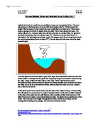
Explain how atmospheric circulation gives rise to the formation of low and high pressure areas in your chosen climatic region
Explain how atmospheric circulation gives rise to the formation of low and high pressure areas in your chosen climatic region. Illustrate and explain the seasonal changes in the distribution of these pressure systems. The circulation of the atmosphere in Tropical regions is described by Hadley's cell. This is affected by two main processes, and pressure gradient force is the first of these. This says that air will move from the area of higher pressure to an area of lower pressure. The greater the difference in pressure, the stronger the airflow will be. The second main process is Coriollis' force. The rotation of the Earth deflects the air moving across the Earth's surface. The rotation deflects air to the right in the Northern Hemisphere and the left in the Southern Hemisphere. These two forces play a major part in the Global Circulation that is the key to the World's climates. Hadley's Cell explains the Tropical circulation; this is a direct cell, as it is a result of direct heating from the sun. It begins at the Equator, where the most intense solar radiation is found, making it the hottest place on Earth. The warm air rises from the Equator causing low pressure. This area of low pressure is often called the Doldrums, and is an area of heavy convectional rainfall. The rising air now spreads out pole wards and cools. The cooling air sinks over the tropics, creating high

Limestone - What is it?
Limestone What Is It? It is a sedimentary rock composed primarily of calcium carbonate (CaCO3). The calcium carbonate was deposited by the remains of marine animals. These organisms secrete shells that settle on ocean floors as a type of gloop. Limestone tends to be organic but it is seldom inorganic. Limestone tends to make up 10% of the accumulated volume of sedimentary rocks. What Is Its Chemical Nature? Limestone is calcium carbonate. It is also moderately soluble in acid, which is a disadvantage when it comes to building. It is made of secreted shells, and limestone can also come into a different form such as chalk, dolomite or marble because of certain pressures in the making of the rock. Why Is It Important As A Building Material? Limestone is very popular in architecture. Limestone is readily available and it is relatively easy to cut in specific shapes or blocks or even for more extensive and elaborate carving in which there is precision design. It is also long-lasting and it is still tough even in exposure. Limestone used for construction is also good in humid and hot environments. What Are The Drawbacks Of Using It In Buildings? Limestone is an extremely heavy material and it is also very expensive to obtain. It is vulnerable to acids, so therefore it is highly susceptible in places where acid rain is a high occurrence. The acids in the rain are capable
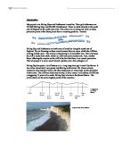
How are Glaciers formed and what land forms do they form ?
How are Glaciers formed and what land forms do they form ? A glacier is formed as a result of an accumulation of snow over a long period of time. The snow puts pressure on the lower layers of snow, which then transform into ice. This is because the weight of the top layers of snow compact the snow so tight that an icy layer forms. This process keeps on going on and starts to expand down the valley. This is due to gravity and space. The Glacier will grow in a v-shaped valley which will then erode into a u-shaped valley. For glaciers to develop the temperature has to be always below 0°C. Glaciers are formed when there is an interruption in the hydrological cycle (water cycle). This happens when the rain drops freeze due to the very low temperatures (has to be below 0°C). The rain drops turn into snow and so the whole process begins. Once the glacier is formed and starts to grow down slope, the snout pushes debris and rocks (see erratics) with it. Eventually when the glacier has stopped growing and as it starts to retreat back up the valley, a ridge of dirt is left at the bottom of the valley. This is called terminal moraine. Recessional moraine is formed when the glacier has already retreated once and grown back down the valley, but not as far as the terminal moraine. Between these two which can act as a natural dam, a lake can be formed. As the glacier grows down slope
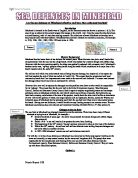
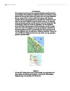
Are the sea defences at Minehead effective and have they enhanced tourism?
Are the sea defences at Minehead effective and have they enhanced tourism? Introduction Minehead is located in the South-west of England, on the Somerset coast (as shown in pictures 1 & 2). The area of sea is subject to the second largest tidal ranges in the world, 14m. Over the years the tides have been a mixed blessing, with it's vary fast running currents. The tides have allowed Minehead to develop into a busy seaside area with their harbour. Minedhead has also been flooded on numerous occasions, for example in 1910, 1936, 1981, 1989, 1990, 1992 and twice in 1996. Picture 1 History/ Background Minehead has had some form of sea defence for several years. When the town was just a small hamlet the only protection from the sea was by a high beach, which was backed by a natural shingle and cobble ridge. However with the town growing rapidly, the ridge was gradually replaced with a masonry wall. Minehead's harbour to the west, 'rip-rap' groynes were placed along the beach which contributed to a major loss of the beach material since the early 20th century. The old sea wall which was under attack was suffering frequent damage, but despite all of its repairs the wall had reached the end of what was called its 'useful life.' This meant that the government and local community found
Birling Gaps and Eastbourne's coastline.
Introduction My project is on Birling Gaps and Eastbourne's coastline. Their grid references are 553,960 (Birling Gap) and 630,003 (Eastbourne). These are both situated in the south east of England on the south east coast. The reason we are doing our work on these particular places is that these places have a recurring problem. Erosion. Birling Gap and Eastbourne are both areas of coastline along the south east of England. We are focusing on these areas because they are areas, which the cliff-face is being eroded away. The erosion is happening at an incredible rate. This is because the cliff is made from chalk, which is a soft and easily eroded rock. Also, another factor affecting the erosion on the cliff is the fact that there is no coastal protection. This is because it is only a small hamlet and has only a few cottages in it. Birling Gap has quite a lot of history to it, a long long time ago it wasn't by the sea. It was miles inland and it was grassy and thriving with animal life. These animals eventually died and their bones and other body parts are what make up the chalk that is there now. The cliff was made very slowly; in fact, every 2 millimetres of cliff took a staggering 75 years to be made. Birling Gap is home to the Seven Sisters. The seven sisters are the seven highest points of the coastline. A diagram of the "seven sisters." A photo of the "Seven
The History of the River Lee.
The History of the River Lee The River Lea or Lee runs from Luton in Bedfordshire to the River Thames in east London. Evidence of Bronze and Iron Age settlements have been found along the length of the river and the Romans built Ermine Street parallel to the Lee shortly after they arrived in Britain around two thousand years ago. During the 9th century the river formed part of the boundary between Saxon England to the west and the invading Vikings to the east, led by King Alfred the Great and Guthrum respectively. It is said that when the Danes sailed up the river in around 895AD and established a base near Ware, Alfred stranded them there by reducing the level of the river. He did this by building an embankment and weir near the Thames, and dividing the river just above Waltham Abbey. How true this is we do not know, but the remains of Viking ships have been found near Hertford and Stanstead Abbots, the river does split into three near Waltham Abbey and the names Kings Weir and Blackwall date back to these times. The waters of the Lee powered many mills producing flour, gunpowder and also England's first paper mill in c1494. As early as 1424 parliament passed an act allowing works to improve navigation, and the Lee was for centuries an important goods highway into London. Malt, flour, coal and gunpowder were all transported in large quantities to the capital. During the

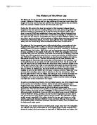
Three Gorges Dam
Super Dams - Triumph or Disaster Introduction The 3 Gorges Dam is a project that will take around 15-20 years to complete. The project is situated on the Yangtze River in central china. The dam will be constructed over the 3 gorge section of the river Yangtze. When completed, it will be a towering 600 feet high and approximately 1.2 miles wide. It will require tens of thousands of workers to be the construction team of the largest dam at present. It is estimated to have a final cost of around £45 billion and will create a lake around 370 miles long. This diagram shows the location of the construction site of the three gorges dam. What environmental problems will does the Chinese government believe that the 3 gorges dam will solve? Over many years, the river Yangtze has been flooding across farmland and cities. This has ruined valuable land and takes a great deal of time to put back the way it was. In the 1996 floods, hundreds of people were killed and millions were forced to leave there homes. Roads, railways and power lines were all cut off. The water that had risen was more than a foot over the danger level. The water that flooded the land was infested with many water born diseases, this water became mixed with the drinking water for many people. All of these problems are aimed to be stopped by the building of the 3 gorges dam. The main problem that the 3 gorges dam

The difference between a straight section and a meandering section.
AIM This investigation is about river channels. We will be investigating the difference between a straight section and a meandering section. Choice of Site? The river we are studying is Millbrook, in the Ashdown forest just south of East Grinstead. The Ashdown Forrest is between 6 major roads, the A23, A272, A22, A275, A264 and the M23. This make Ashdown forest an incredibly accessible place. We decide to survey Millbrook for many reasons, the school we attend, Reigate Grammar School, is relatively close to the river, and other nearby rivers were not usable because of the foot and mouth crisis earlier in the year. Also the river had quality's which meant it would not be too hard to study. As we only had basic equipment, tape measure and metre rulers, if the river had been too deep or too wide we would have had a lot of trouble taking even these simple measurements. The river was also "manageable" by this I mean that the river was not too fast, if the river was too fast it could have been dangerous too stand in the river. Though these were all good reasons too study this river we wouldn't be able to unless we gained permission from the conservators, which we had. We also studied the river in September, as this is when most rivers are at there lowest. When we arrived at the river we soon realised that not every section of the river would be suitable to study. We
Coastal coursework
Introduction The project is about how the northeast Norfolk coastline should be managed, the coastline is suffering badly from erosion, some places are worse than others and there are a lot of sea defences put up, some of this is due to global warming, with the seas rising it will put more pressure on the cliffs, the Yorkshire coast down to the north Suffolk is mainly bolder clay so it is wearing away extremely quickly and the coast is very low lying land the combination of the two could be disasters. On the coastline around Norfolk the long shore drift travels from north to south down the coast, this happens in all the coastlines in Norfolk it's the same system around, not just little bits, the long shore drift carries different bits of materials to different beaches. There are a lot of different defences some are: sea walls, rip rap, gorgers, gabions, granite reefs. Method On the 23rd of May there was a school field trip organized and they visited the following locations: Overstrand, Mundesley, Happisburgh, sea palling and Winterton. In order to carry out these investigations we had a variety of tasks. Observing the environment closely, we made notes, which included field sketches, and also took photos. The erosion occurring at each place, together with the soil type, land use, bolder clay and defences. Details of our findings are included later on in the project. Long
Measuring the Intensity of Earthquakes.
Earthquakes General An earthquake is a shaking or trembling of the crust of the earth caused by underground volcanic action or by the breaking and shifting of rock beneath the surface. The volcanic action and shifting rocks create strain which continues to build to a sudden release of pressure resulting in a shock wave. The vibrations produced in the crust can vary from barely noticeable to enormously destructive. Shock waves can be classified into two broad categories. Waves that send particles oscillating back and forth in the same direction as the waves are traveling are called primary. Primary waves, sometimes called compressional waves, travel through the earth beneath the crust. Secondary waves cause vibrations which move perpendicular to the wave. These waves travel on the surface of the earth and move much slower than primary waves. Thus, when an earthquake occurs, seismic centers throughout the world record primary waves before the secondary waves arrive. Historical Overview Earthquakes have captured the imagination of people living in earthquake prone regions since ancient times. Ancient Greek philosophers thought quakes were caused by subterranean winds, while others blamed them on fires in the bowels of the earth. About AD 130, a Chinese scholar named Chang Heng reasoned that waves must ripple through the earth from the source of an earthquake. By 1859, an


