
Discuss the relative importance of physical and human factors in accounting for changes to vegetation over time within ecosystems in the British Isles
Discuss the relative importance of physical and human factors in accounting for changes to vegetation over time within ecosystems in the British Isles The British Isles is an example of a Lithosere succession, in that it began as bare rock from glacial retreat. The plant succession started with the pioneer species which were algae and bacteria. Both began to broke down rock surface through weathering. Then lichens and mosses began growing in the area which helps with water retention and provides a base for soil. The next stage of primary succession is herbs/grasses/flowering plants/ferns. These add nutrients and organic matter to the ground which provided soil. Next, shrubs invaded and colonised the area. Shrubs dominate and shade out the sere below them. Small trees such as birch and willow were the following sere which invaded and colonised the area. They produced humus from leaf fall which provided nutrients for the soil through nutrient recycling and encouraged new growth of the sere. The last sere is the larger trees which are oak and ash which dominate the area and shade out smaller trees. This sere is the climax community in that it is stable and no further succession happens after. The climax community is the deciduous woodland biome we know today. The main characteristics include the location in which they are found, which is in temperate maritime climate such as

Discuss the degree to which the theory of plate tectonics is supported by seismic and volcanic activity
Discuss the degree to which the theory of plate tectonics is supported by seismic and volcanic activity. The theory of plate tectonics suggests that the earth's lithosphere is split into plates (as shown in map 1). At their boundaries the plates submerge, diverge and slide past one another, this movement is caused by convection currents in the asthenosphere. The idea that the plates are moving is not new, as early as 1620 the English philosopher Francis Bacon was aware that the continents seemed to fit together. In 1912 Wegener suggested that the continents were once joined as the super continent Pangaea (as seen in image 4) and that they had drifted apart, he gathered a large amount of evidence to support this theory. Continents appear to fit together, more significantly so if continental shelves are taken to be the true edges of the land mass. There is a vast array of geological evidence that includes similar glacial deposits being found in Antarctica, S. America and India. Antarctica, Svalbard, N. America and the UK all contain coal deposits of a similar age that were formed in tropical conditions, they are no longer in tropical climate zones. Biological evidence is also available, Marsupials are only found in Australia because the predator that wiped them out elsewhere had not migrated there before it drifted away from the main super continent. Despite this evidence,

Cholera - its global impact
Cholera Cholera is an infectious disease caused by the bacterium Vibrio cholera, which usually spreads through contaminated water. It affects the absorption of water in the small intestine and in severe cases produces severe diarrhoea. The most dangerous aspect of Cholera is the immense loss of fluid that can occur within a few days. Without treatment within 24 hours of developing the disease, the loss of fluid can be fatal. Many cases, such as those in Zimbabwe, require hospitalisation of infected people so that fluids can be administered straight into the bloodstream with the use of a drip. Cholera bacteria occur naturally in coastal waters, where they attach to tiny crustaceans called Copepods. The Cholera bacteria travel with the Copepods, spreading worldwide as the crustaceans follow their food sources, which are certain types of algae and plankton. These grow rapidly when the water temperatures rise and algae growth is further increased by the urea found in sewage and agricultural runoff. Therefore most Cholera outbreaks occur in spring and autumn when ocean surface temperatures and algae blooms are at their highest. More algae mean more Copepods, and more Copepods mean more Cholera bacteria. The map on the left shows that the areas that Cholera is discovered in are situated below the Brandt line. This is because these areas are surrounded by warm oceans where the

The number of fatalities that result from volcanic and seismic natural hazards is related to the level of development in the country in which they occur. Discuss.
The number of fatalities that result from volcanic and seismic natural hazards is related to the level of development in the country in which they occur. Discuss. A natural hazard is an event, linked to the physical environment, which is considered to have a negative effect on humans. The event is also seen to be unpreventable by humans. However, an event such as a volcanic eruption that has no effect on human beings is considered a natural phenomenon rather than a natural hazard. It is the presence of humans, in an area that such an event occurs, that allows it to be termed a hazard. Although humans cannot prevent these occurrences, they have a role to play in the event's extremity as a natural hazard. For example, volcanic eruptions have been present throughout history, but it is not until settlements are built on the rich soils they form that they become a hazard. This essay I will evaluate the extent to which the level of development in a country affects the number of fatalities caused by volcanic and seismic natural hazards. A volcanic natural hazard is a volcanic eruption. Volcanoes are formed at convergent and divergent plate boundaries and also at hot spots. At convergent plate boundaries eruptions tend to be from a vent, as oceanic crust is forced beneath another plate, the extremities of heat and pressure leads to the partial melting of the crust which is being
Temperature Inversions.
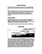
Temperature Inversions Normally, the air near the ground is warmer than the air at higher altitude. An inversion is the reverse situation--colder air at ground level than higher up. Cold air is heavier than warm air. Thus once an inversion forms, the air is very stable. Mixing that would normally occur by the rising of warm air is inhibited. Consequently pollutants such as carbon monoxide, sulphur compounds and ice fog remain trapped near the ground when there is an inversion. Types of Inversions The stability and mixing of air near the surface is controlled to a great degree by the presence of temperature inversions in the lower atmosphere. These inversions typically are very extensive, blanketing entire cities or regions. In each case, warm air is produced over a layer of cooler air in contact with the surface. There are basically four types of temperature inversions, each are explained below. Marine Inversions If you live near a coastline, you have probably experienced a marine inversion layer. Near cool oceans, such as in the western U.S. and Western Europe, a marine inversion can turn a hot summer day at the beach into a cool, foggy, overcast shiver. The ocean is typically quite cool compared with the land, particularly at middle latitudes where the heating by sunlight is not strong. Air sitting over cold water also tends to be cool. Moreover, a great deal of

Urban Areas have a significant impact on climatic characteristics Discuss.
Katie-Jane Sullivan "Urban Areas have a significant impact on climatic characteristics" Discuss. An urban area is characterised by a high population density and vast human features in comparison to areas surrounding it. Urban areas are created and further developed by the process of urbanisation. Other characteristics of urban areas include high rise buildings, good transport links and large amounts of vehicles. These characteristics, together with the high population density, means they have a significant impact on climatic characteristics. One climatic characteristic that urban areas affect is the cloud cover. Urban areas generally have 5-10% more close cover due to the greater concentration of condensation nuclei. This encourages the cloud formation due to the heating which increases the uplift of air. Similarly urban areas also have a significant impact on the precipitation levels. For example, urban areas are more prone to thunderstorms due to the enhanced convectional uplift. Another climatic characteristic that is affected is the wind. Urban areas have lower wind speeds due to the roughness of land surfaces. This is due to the varying height of buildings which exerts a fractional drag on the air moving over and around these buildings. This creates turbulence, giving rapid and abrupt changes in the wind speed and direction. Usually the greater area of buildings

In December's tsunami in the Indian Ocean, an estimated 250,000-300,000 people were killed or are still missing, while millions of lives have been upturned, socially and economically, by its impact. A main reason for the huge death
Why are some hazards easier to predict then others? For my essay I will looking at different case studies and reasons why it appears that some hazards are easier to predict then others. There were 497 reported natural hazards that took a significant human toll - between 1974 and 1978. The last five years have seen 1,897 of them, a nearly three fold increase. Between 1974 and 1978, 195 million people were killed by such disasters or needed emergency aid; there were 1.5 billion such victims in the past five years. Natural hazards are happening more often, and having an ever more dramatic impact on the world in terms of both their human and economic costs. While the number of lives lost has declined in the past 20 years - 800,000 people died from natural disasters in the 1990s, compared with 2 million in the 1970s - the number of people affected has risen. Over the past decade, the total affected by natural hazards has tripled to 2 billion. According to wordnet.princeton.edu/perl/webwn a hazard is: - a source of danger; a possibility of incurring loss or misfortune. Predict is defined as:-The skill of explaining new events based on observations or information. According to: - www.dpi.state.wi.us/standards/sciglos.html When looking at the different types of hazards to injure or kill people, or costing the most economic price, we consider such hazards as tsunamis and

Explain why, for both physical and human reasons, some coastlines attract more management than others.
Explain why, for both physical and human reasons, some coastlines attract more management than others. Coastal management involves controlling development and change, and undertaking works in the coastal zone. Good management involves taking into account both physical and environmental considerations, as well as the views of local residents and others involved. There are two different types of coastal engineering, the 'hard' and 'soft' strategies. Hard engineering includes man made defences such as sea walls, a costly wall place on the seaward side away from the base of the cliffs needing an additional advanced line of protection such as rocks on their seaward side. Groynes, timber posts and boards which run out to the sea at right angles to trap sediment drifting along the coast. Gabions, cages enclosing shingle or small blocks of rocks, and revetments, defences that are aligned parallel to the shore including post, pillars or walls of rocks placed on the foreshore. Soft engineering includes planting trees and grasses in and around the beach, encouraging sand nourishment by adding more sand, and then most drastically, a managed retreat which involves moving homes and farmland. Physical influences such as the type of wave and fetch can determine the type of management used. For instance, if an area with a high, destructive wave count was not to receive a management scheme,

Volcanic & Seismic events are pieces of evidence proving that the plate tectonics theory is valid
Volcanic & Seismic events are pieces of evidence proving that the plate tectonics theory is valid The plate tectonics theory was put forward by Alfred Wegener suggesting that the continents were at one point all conjoined in one supercontinent known as Pangaea. He then suggested that Pangaea had drifted apart through the movement of plates to give us the current position of continents we have today. Wegener's theory was linked to a variety of evidence, however it took further research and evidence for this to become a leading theory. This means that although volcanic and seismic events help to prove the plate tectonics theory valid, there is also a range of other factors involved. Vulcanicity is the surface presence of Magma within the Earth's crust. Whereas seismicity is where the build up of pressure in the crust is released. Both volcanic and seismic activty when plotted on a map can be seen to follow certain patterns and it is this distribution that helps explain the plate theory. The distributions of earthquake events are found in broad, uneven belts around plate margins and it is the movement of the plates that cause the seismic events. Most of these earthquakes occur along destructive margins, where the heavier oceanic crust descends underneath continental crust. A build up of pressure here, where no subduction takes place for a space of time, eventually leads to a

Understanding natural systems is the key to successful management of coasts. To what extent do you agree with this view?
Understanding natural systems is the key to successful management of coasts. To what extent do you agree with this view? To manage a coast successfully, the effects of erosion, flooding and unwanted deposition must all be minimized as much as possible. Furthermore the protection of people and their property also forms a good basis of good coastal management. It is true that to be able to set up good defences, the natural systems surrounding the coast must be understood, as this ultimately allows the management agencies to fully examine and decide the type of management that should be used. Coastal processes such as erosion and deposition are the main natural systems that affect our coast and thus must be monitored to ensure the best management strategy is in place. However the wave type and the amount of wave energy that is apparent at that stretch of coast ultimately decides the rate of erosion and deposition. The energy input of a wave is due to the wave height; the distance between the crest and the trough, the wave period; the time taken for a wave to travel through one wave length, and the wave steepness; the ratio of the wave height and wave length. Furthermore, the fetch of the wave will also influence the amount of energy that a wave has and therefore a wave with a high-energy value will potentially cause more damage than a wave with a low energy value. Spatial


