In the last part of the rivers journey, it flows through a gentle sloping flood plain. A flood plain is an area of flat land found on either side of a river. This usually becomes wider as the river nears its mouth. The flood plain is the area of land which is flooded when a river overflows its banks. In these areas the soils is thick and fertile and the land is flat.
Because the plain is nearly level, the meanders in the river get even bigger compared to
the mid-section.
When a meandering river flows through a flood plain it is called a mature river. In the lower part of the river ox bow lakes are also formed. Ox bow lakes are a truncated (cut off) section of a meander in the river channel which forms a 'c' shape. It is formed when the loops in a meander eroding the flood plain until eventually the loop in the meander is left cut off from the main river channel.
The final stage of the river is when it reaches the sea at this stage the water flow is very slow. The water also carries clay and sand and because the water is so slow it is deposited this often forms deltas. A delta is a 'D' - shaped area of sandy / muddy sediment built up into the open water where a river meets the sea or a loch.
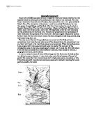
This diagram below shows a picture of a plain river. It shows the nature of a drainage basin and the parts that make up the river. A drainage basin is an area from which a stream and its tributaries receive their water. Most precipitation that falls on a drainage basin will eventually reach a main river and flow to the sea. A drainage divide divides or separated different basins. A catchment is the area drained by a stream, lake or other body of water.
Legend:
This is a model of a river but other than this a river also has many processes that I will talk about. They can be split into erosional, transportational and depositional. I will now explain each of these in detail.
Erosion is when the land is worn down by the action of water, ice or wind in a river there are 4 types of erosion.
Attrition is the knocking of rock fragments in the water against one another. The fragments are broken into smaller pieces and become smoother along the process.
Corrosion, also known as corrosion, is the process by which river water reacts chemically with soluble minerals in the rocks and dissolves them.
For example, when a river stream flows over an area of limestone (calcium carbonate), it erodes the limestone by reacting chemically with it and dissolves it.
Abrasion, otherwise known as abrasion, is the grinding of rock fragments carried by the river against the bed and banks of the river. This action both widens and deepens the channel. The power of the grinding is especially powerful in floods when large fragments of rock are carried along the river bed eroding the bed and the banks.
Hydraulic action is the breaking down of rocks and dragging them away from the bed and banks by the force of the running water itself. When water from a fast moving stream enters cracks in a rock, the force breaks up the force into pieces.
Transportation is when the water is used to transport material through the river like mud, sand, boulders and dissolved material. There are 4 types of transportation
Traction
Larger particles like pebbles and boulders roll and slide along the river bed.
Saltation
Large particles such as gravel and coarse sand are lifted and dropped along the river, so they bounce along the river bed in a series of bed.
Solution
Dissolved materials containing minerals like calcium and sodium are carried in the water. Trying to look out for this type of load in a river is very hard because they cannot be seen by a naked eye.
Smaller particles such as clay, silt and fine sand are carried along without contact with the river bed. Materials carried in suspension usually forms the greatest part of the total river bed.
Deposition is the opposite of erosion. Deposition is where a river lays down or drops the sediment or material that it is carrying. Rivers carry lots of different sediment, including rocks, boulders, silt, mud, pebbles and stones. Normally, a river has the power to carry sediment. If the force of a river drops, the river cannot carry sediment. This is when the river deposits its sediment. There can be much evidence of deposition in a river. Some examples are:
1. Areas of pebbles and stones.
2. Areas where mud and sand and silt have been deposited.
3. Large boulders and stones in the middle of a river.
4. Tree branches and trees in the river.
5. Pollution like cans, bottles, crisp wrappers and other rubbish
All of the processes above occur at different points along the river to a certain degree. The combination of these processes causes the particular features of a river which I have talked about. At the mouth you get lots of erosion because the water is fast moving and the land is steep. Steep land makes the river flow faster. Fast flowing water has lots of energy this energy is used up by breaking big bits of river bed and bank off here the load carried by the river tends to be large and very angular.
As you reach the mid-section the processes change and you get a lot of transportation occurring. The gradient gets less steep and the river speed therefore the speed decreases. This causes a drop in energy levels. As the river has less energy it carries less heavy objects. This means the river load tends to get smaller. As these particles are carried along the process of attrition gets to work making the pebbles more rounded. This occurs because the knocking of rock fragments in the water against one another means that the fragments are broken into smaller pieces and become smoother. The river in the mid-section is joined by smaller tributaries which does make the width of the river larger as well as the depth. As a river winds its way from its source to its mouth A number of processes of erosion take place like corrosion this is the wearing away of the river channel by water.
As you move to the mouth of the river the gradient is almost flat. This means the energy levels have completely dropped making the river process mainly depositional. The river speed is very slow and the pebbles carried become less rounded because the speed of the water becomes less fast so attrition cannot work as well as at the start of the river.
As you move through each of the three phases of a river the different processes create different features like the ones I have talked about.
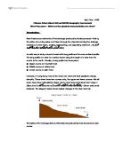
The river process therefore creates distinctive features if left to its own natural flow. Today though many rivers are influences by humans it can dramatically alter the path and process which therefore alter the features of a river. To summarise how a river changes throughout the three stages the water cycle is one of the best ways to see it. This diagram is of the cycle of a river “The River Cycle”.
This cycle shows the rivers journey from source to mouth and shows most of the key processes that happen throughout its journey. However the model of a river on the first page gives a better visual aid as to how a river looks from its beginning to end.
Methodology
To see if the river Cray does follow the path of a natural river I am going to carry out some experiments. Because I do not have enough time I will carry out these experiments in three different locations along its course. One will be in the source, one in its mid-section, and one in the mouth of the river. I will then be able to compare the river in these areas with each other and that of the text book. I have chosen to carry out 7 experiments to test my hypothesis. These are:
- River speed
- River gradient
- River width
- River cross-section
- Pebble shape
- Pebble size
- Pollution
For each of these experiments I will be looking at the aim, hypothesis, equipment needed and limitations.
River speed:
Aim – to test how the speed of the river changes from source to mouth
Hypothesis – I expect the river Cray to have a fast flow in the source and then the flows speed will decrease as I move to the mouth. I explained why in the introduction but basically it is linked to the gradient.
Equipment – tape measure, 3 people, record sheet, ping pong ball, stop watch.
Method – To work out the speed we are going to measure how long a ping pong ball takes to travel a set distance. We know that:
Speed = Distance/Time
So if the distance between two banks was 10 meters and the ping pong ball to 10 seconds to get across, the speed would be 1m/s.
River gradient:
Aim – to test how the depth of the river changes from source to mouth
Hypothesis – I expect the river Cray to be steep in the source and then the depth will decrease as I move to the mouth. This will be because rivers start in high places and gradually flow to low places
Equipment – tape measure, 3 people, and record sheet.
Method – measure depth in intervals across the river, to work out cross section of channel. Then you can see how the river banks depth either increases or decreases.
So if the distance between 4 intervals is 20, 15, 10, 5 cm then you can see that the gradient has decreased because the intervals get less and less.
River width:
Aim – to test how the width of the river changes from source to mouth
Hypothesis – I expect the river Cray to have a small width in the source and then the width will increase as I move to the mouth. This is because at the start of the river is only small, but the width should increase because as the river gets to the mouth it is accompanied by tributaries which increases river width.
Equipment – tape measure, 2 people, and record sheet.
Method – measure width in intervals across the river.
River Cross-section:
Aim – to test how the profile of the river changes from source to mouth
Hypothesis – I expect the river Cray to be shallow and skinny in the source and then the depth and the width will increases as I move to the mouth.
Equipment – tape measure, ruler, 3 people, and record sheet.
Method – measure depth of river in intervals across river with ridge meter ruler. You can then make a graph which shows the rivers profile.
.
Pebble shape:
Aim – to test how the pebble angularity in the river changes from source to mouth
Hypothesis –I expect the pebble shape to be more rounded because the water is fast and attrition makes the pebbles smooth and round. As the pebbles go to the mouth they should get sharper because attrition cannot work on the slow water conditions.
Equipment – tape measure, 3 people, and record sheet.
Method – measure depth in intervals across the river, to work out cross section of channel. Then you can see how the river banks depth either increases or decreases.
So if the distance between 4 intervals is 20, 15, 10, 5 cm then you can see that the gradient has decreased because the intervals get less and less
Pebble size:
Aim – to test how the pebble size in the river changes from source to mouth
Hypothesis –I expect the pebble size to be small at the source because the water is fast and erosion makes the pebbles smaller. As the pebbles go to the mouth they should get bigger because the erosion cannot work on the slow water conditions.
Equipment – rule, paper.
Method – measure several pebbles at the three parts of the river then compare them.
Pollution:
Aim – to test how the pollution in the river changes from source to mouth
Hypothesis – I expect the pollution to be less in the source because the water is fresh and doesn’t have any contamination. The pollution should rise as we get to the mouth because there is mud and lots of solutions contaminating the water.
Equipment – litmus paper, recording sheet.
Method – dip paper in water and record the ph.
Below are the tables I have used with my results:
River Speed
River Gradient
River Depth & Width
Pebble shape
Pebble size
Pollution
This shows that the faster the speed the larger the pebble size.
This shows that the steeper the gradient the faster the speed.
These are charts for difference in pebble shape. It tells us that the pebbles become more rounded and less angular from source to mouth
These are graphs that show the cross section of the river at the source, mid-section and the mouth. It tells us that at the mouth the river is less deep and less wide but as we get to the mouth it get deeper and wider.
From my experiments I have found out that to my surprise the river Cray is very similar in some ways to a river from taken from a common text book I expected the river Cray to have a fast flow in the source. Then the flows speed decrease as I move to the mouth. This was correct and the same as a text book river. I expected the river Cray to be steep in the source, then the depth decrease as I moved to the mouth. This was also correct and similar to a text book river. This was also the same for River cross-section, Pebble shape, Pebble size, Pollution. However the river width was different to the one of a text book river. I expected the river Cray to be shallow and skinny in the source and then the depth and the width to increases as I moved to the mouth, but instead the graphs told me that at the source the river is less deep and less wide but as we get to the mouth it get deeper and wider, But not by much. In a text book river the source is usually only a tiny stream and the mouth has a large width and is very deep. I believe that the river Cray differs slightly from the one in a text book because many reasons. Human intervention is one cause. This is because human have put up walls against the bank of the river so it cannot flow naturally and grow as a normal river would. Another reason why the river Cray is different from text Book Rivers is because it is only a tributary and tributaries tend to be smaller that rivers. I think I have achieved my aim in comparing the river Cray to a common text book river.
The results here can be misleading though. Since we only completed results in three locations, which is a small fraction of the rivers length, this means that my conclusion can only be very limited. What these results do not show is that the speed of the river is directly influenced by humans. At the source of the river the flow goes under a road through human construction pipes. This controls the flow of water, also at the mid section there is a weir that also controls flow of water.
There were many limitations to my project though, the study sites were all within the same drainage basin the different sites were only visited once, on one day, and in one season the equipment used to take the measurements was very basic and did not enable us to gain precise results and there were many more like that the different people recorded different results. The list goes on. I think that we could have used better equipment, took reading from more that 3 locations and let one person take all the readings (which would make it more fair) to make this project more successful.