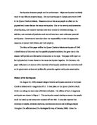
Figure 2 (above) Figure 3 (below): The Juan de Fuca plate lies offshore between Vancouver Island and northern California. The San Andreas Fault extends to the south and the Queen Charlotte fault to the north. In the Cascadia Subduction Zone, the Juan de Fuca plate slides under the North American plate causing earthquake activity along the fault lines (The Geological Survey of Canada, 2000).
Human Utilization of Area
Geographical areas that have a history of earthquakes are vulnerable to human activity. Human activity can increase stress within the earth that can lead to rock rupture under the earth’s surface and destructive ground movements (Siegel). Humans may contribute to the cause of earthquakes through an array of activities such as the filling of new reservoirs, the detonation of underground atomic explosives, or the injection of fluids deep into the ground through wells for oil recovery or waste disposal. Cases such as these have been recorded in several areas, including the United States, Canada, Japan, and India (The Geological Survey of Canada, 2000). In recent years, large buildings, roadways and other infrastructures have been built on reclaimed land, steep slopes and unstable soils. These areas are at high risk of being damaged by a large earthquake. This also means that in the future, earthquakes in these built-up areas could affect more people and cause more damage than in the past (Emergency Preparedness Canada, “Emergency Preparedness”, 2001). Humans make themselves susceptible to property and personal damages by residing in high-risk areas such as the Queen Charlotte Islands.
Hazards
Following a major earthquake, British Columbia can expect to confront power outages, communication disruptions, damages in building structures, food and water shortages, personal injuries or deaths, blockages of transportation routes, interruption of social services and several other serious perils (British Columbia, Legislative Assembly, 1999). Property damage would be extensive, amounting to billions of dollars. Earthquakes also trigger fires, floods and dam breaks that would alone cost a large sum in repairs.
Massive earthquakes in high-risk, high-populated areas cause, “casualties, property loss, disruption of lifelines and collapse of regional economic and social infrastructures which would be catastrophic” (Emergency Preparedness Canada, National Support Plan, 1991). To protect people and their property from natural hazards such as earthquakes, some insurance companies in British Columbia sell insurance policies for these specific events. Earthquake insurance in British Columbia is currently relatively inexpensive. In spite of this, the Insurance Bureau of Canada notes that many British Columbians do not buy separate earthquake insurance policies (British Columbia, Legislative Assembly, 1999).
Human settlement also causes earthquakes to become natural hazards simply by being there. Humans are not a physical trigger to an earthquake event, but humans choose to place buildings, roads, etc. in places that are susceptible to damage from natural disasters. Therefore, humans are indirectly a hazard in high-risk areas.
The Queen Charlotte Islands are comprised of 150 islands and have a very small population of only 5,600 inhabitants. The Queen Charlotte Islands is largely a resource based economy, with forestry as its principal sector. The non-industrialized lands of the Queen Charlotte Islands would not experience the same degree of destruction from an earthquake as would a city such as Vancouver. Vancouver is a highly-populated and highly-industrialized city. A major earthquake would generate more damage in Vancouver than in the Queen Charlotte Islands due to its numerous industrial structures and more-complex infrastructure. With the hazard of tumbling buildings in a city with a higher population in a more compact area, Vancouver would likely see more deaths and destruction from an earthquake than the Queen Charlotte Islands. Just over two million people reside in metropolitan Vancouver compared to the 5,600 that inhabit the Queen Charlotte Islands. There were no fatalities in the 1949 Queen Charlotte Islands earthquake or in the recent earthquake of magnitude 6.2 in Masset, British Columbia (in the Queen Charlotte Islands) on February 17, 2001 (The Geological Survey of Canada, 2000). Earthquakes with the same or less magnitude as these earthquakes which occur in highly populated places have killed thousands of people. For example, another magnitude 8.1 earthquake on September 19, 1985 in Mexico City killed at least 8,000 people. Five hundred buildings in Mexico City were severely damaged. Although the earthquake killed over 8,000 people, causalities would have been much higher if the quake had occurred just a couple hours later when the schools and office buildings would have been full with people (Seismo-Watch, 2001).
The number of victims and the extent of the damage depend on the time of the occurrence, climatic conditions, area demographics, severity of aftershocks and building construction (Emergency Preparedness Canada, National Support Plan, 1991).
Ground shaking is the main source of earthquake damage, however there are consequential effects such as landslides, the liquification of sediment, flooding of low-lying areas, and tsunamis or tidal waves sweeping over coastlines can also cause loss of life and massive destruction to property and the environment (Siegel). A tsunami, a series of travelling waves produced by an earthquake below the floor of the ocean, can rush over low-lying coastal areas and cause severe damage (The Geological Survey of Canada, 2000). Not all underwater earthquakes cause tsunamis, however. Most earthquakes under the ocean are too small to trigger a tsunami. Even a very large earthquake, such as the Queen Charlotte Islands earthquake in 1949 did not generate a tsunami. In the case of this earthquake the movement of the seafloor was a horizontal slip, and not the vertical motion required to generate a tsunami (The Geological Survey of Canada, 2000).
Prediction and Control
With the extent of scientific knowledge that there is today, it is not possible to predict earthquakes and undoubtedly not possible to specify the exact date, time and location prior to their occurrence (Ludwin). Nevertheless, a great amount of research is being conducted to expand dependable methods of prediction. Since forecasting future events is, for seismologists, fascinating and also their ultimate goal, a “striking progress” has been made in earthquake prediction in recent years (Mogi). Along with other countries, Canada is working to develop methods to minimize damage and injuries through the introduction of modern-earthquake-resistant standards so that citizens will be safe when an earthquake occurs (The Geological Survey of Canada, 2000). No one can tell exactly where or when the next major earthquake will occur. Even with the best systems and historical information in an area today, earthquakes have occurred without warning. However, seismologists have methods that they currently use that can at least allow them to make calculated guesses. Firstly, a statistical method of study looks at the history of earthquakes and their frequency in a region to estimate when and where future earthquakes may occur. Secondly, seismologists use a geophysical method of study where they use observations and interpretations of changes in geometrical, metrical, thermal and chemical aspects of the earth’s behaviour to indicate an approaching earthquake in an area (Tatsch). In this method, seismologists measure how much stress a certain region of the earth's crust is under, and how quickly that stress is increasing. That knowledge, along with the amount of time that has passed since the last earthquake, helps scientists find out if another earthquake is to be expected in the region. This method of study is not faultless, however, and involves comprehensive seismological data which is not available for most regions (CBC).
Government Protection and Preparedness
A timely prediction of earthquakes is extremely important in lessening damage and injuries. To minimize the loss of lives and property damage, there must be a plan of action, accurate prediction techniques and proper construction of buildings for when and earthquake occurs. British Columbia has a serious risk of damage due to the proximity of the Queen Charlotte Fault, and the provincial and federal governments have a large responsibility to ensure safety throughout the province. The Federal Government implemented the National Building Code of Canada, an important function of the Canadian National Earthquake Hazards Program. The code provides standards for earthquake-resistant construction in earthquake-prone zones (The Geological Survey of Canada, 2000). The earthquake-proof design is an effort to give structures, their foundation and contents, features which enable them to survive earthquakes. The construction of buildings in the Code differs depending on the structure’s geographical location, the type of structure, the soil foundation and the importance of the building in an earthquake. Buildings such as fire stations and hospitals have a higher degree of protection. Buildings must be constructed to absorb energy and prevent collapse (The Geological Survey of Canada, 2000).
British Columbia also continues to work towards increasing the safety and security of the residents. In a news release in March 2001, Environment Minister of British Columbia, David Anderson, comments, “The recent earthquake which struck Washington State and British Columbia, demonstrates how unpredictable nature can be. Disasters can strike anywhere at any time. That is why it is important to be prepared” (Emergency Preparedness Canada, “Emergency Preparedness”, 2001). Canada, in support of its west-coast, earthquake susceptible province, has designated the first week in May as Emergency Preparedness Week in Canada. Canadian Minister for National Defence, Art Eggleton, comments, “All Canadians should be aware of the risks in their community and how to better prepare themselves and their communities in order to reduce the potential effects of disasters” (Emergency Preparedness Canada, “Emergency Preparedness”, 2001). British Columbia might not be doing all it can, however, to prepare for a major earthquake. The province’s Auditor General, George Morfitt, who analysed B.C.'s Provincial Emergency Program (PEP), concluded that "governments in British Columbia are not well prepared for a major earthquake." He also remarked that one on five local governments had done no earthquake planning at all. In his report, he wrote that PEP staff are "likely to experience difficulty [following a major quake] because they have not yet developed specific, comprehensive scenarios for all high hazard, high risk areas of the province" (CBC News, 1999).
Emergency response is important during times of natural hazard occurrences. It is especially necessary in larger cities where there is potential for great damage and where there is a greater population. British Columbia’s Emergency Response Management System (BCERMS), “ensures a coordinated and organized response and recovery to all emergency incidents and disaster. It provides the framework for a standardized emergency response in British Columbia” (British Columbia Emergency Response Management System, 2000). Since British Columbia is prone to earthquake disasters, the BCERMS is a crucial function to control emergencies.
Conclusion
British Columbia is a high-risk province for earthquake catastrophes. With highly industrialized cities, such as Vancouver, in areas nearby earthquake activity, we learn that much work must be done to prevent major damage and protect lives. The Queen Charlotte Islands, which are earthquake active even today, give us a reason to help defend large cities from potential earthquake devastations. The governments, both provincial and federal, are working to ensure they can provide the necessary safety to people and property in the face of disaster. The support of the entire nation, not only British Columbia, is essential for potential emergencies. Through time, seismologists will continue their research on earthquakes and seismic activity and will be able to inform the governments of the future earthquakes so that they can take the necessary precautions that will protect us and increase our safety. About 1500 small earthquakes occur every year in Canada, whereas major earthquakes, like the 1949 Queen Charlotte Islands earthquake, have occurred only a few times in this century. A small earthquake, however, provides an ideal opportunity to offer reminders about safety measures to take before, during and after an earthquake (The Geological Survey of Canada, 2000). We are going to have another major earthquake. It is merely a matter of time until it happens, so we must prepare to the best of our abilities.