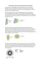
Peter Mann took Hoyt's and Burgess's models and combined them in his model of a typical British City in 1965. He based his model on studies of Sheffield, Nottingham and Huddersfield. The model proposed that a city had rings, ranging from the CBD to commuter villages on the periphery of the city, as well as being divided into sectors of middle class, lower middle class, working class and lowest working class.
The Multiple-nuclei model; developed by Ullman and Harris in 1945 aimed to further describe the layout of a city. This model takes suburbanisation into consideration; it contains nine different sections which all have separate functions. These nuclei then develop into independent areas because of their activities e.g. economic activities which support each other will form a nucleus and then other nuclei form as they’re better off far from one another.
In practice with real urban areas, the usefulness of each model is different. The Hoyt model is useful in regards to some cities. Bristol; for example seems to follow it, it has a very clear industrial sector following the main rail line and the river Avon. Despite the division between land uses being far too clear cut, they do provide a bench mark for comparison and allow us to have a basic understanding of the complex processes that determine the distribution of land use within a city. However the model is oblivious to physical environment; much like Burgess’ and it’s not made clear either, about the growth of out-of town areas. The growth of a sector can be stopped as land-use leapfrogs out of the old inner city. For example, out-of-town council estates have prevented large high class sectors developing in other areas of Bristol.
Burgess’ model can be followed by a number of cities if taken in a very broad pattern. It helps explain the process involved in the growth of a city, the model is relevant in identifying the reasons behind urban morphology of a city; despite the model not referring to changes in transport routes or society. Yet Burgess could not have foreseen these changes to urban areas. The CBD of Birmingham follows the model of Burgess, it’s highly industrialised with shopping centres (the Bullring) and multi-storey buildings.
Mann’s model is recent and has proved useful as a model for many cities, especially Nottingham, Sheffield and Huddersfield, since Mann based his investigation on these cities. The Multi-nuclei model, formed by Ullman and Harris shows how characteristics of parts of the city help to develop it, forming nuclei where different resources and opportunities are available. Gloucester is an example which loosely follows this model. The central docks provide a brownfield site ripe for development in which many industries have flourished, the CBD expands whilst shops in the rural-urban fringe shut due to commuters shopping in the CBD, which results in a decrease in size of the urban fringe etc. Although the model can really only apply to cities that have developed from several centers e.g. Los Angeles or Stoke-on-Trent
One reason why urban models do not fit real urban areas is that regeneration and gentrification was not acknowledged during their creation, especially with Hoyt and Burgess. Watford Arches Retail Park, which is located on a former industrial site wouldn’t be able to be liked in with an urban model. Run down terraced housing is often bought by investors and improved to appeal to young professionals who need access to the CBD which destroys the design of most models which state that the inner city is run down and the rural-urban fringe is serene and houses the wealthier classes.
Another reason for urban areas not always matching the various urban models is because each model is based on a specific city at a particular time, therefore not all cities are the same and the model cannot exemplify every unique characteristic of every individual city. In reference to Hoyt and Burgess, the clarity of the “rings” within the city is too much. All zones of a city have a mixture of land uses. Residential zones will have industry and shops within them, just as the CBD may contain a few high rise flats like in Scotland.
Thirdly, urban models are simplified diagrams, created by making generalisations so they’re never going to fit precisely to a city which is constantly changing and has unique land uses and developments which help to conform its morphology.
In conclusion, urban models are useful to a geographer studying urban areas, they provide a comparison and a guide to the morphology of an urban area. They help explain the processes involved in the growth of a city. However no city directly follows an urban model so these models are only useful to an extent. Each city has unique characteristics and thus unique land uses too, which may differ from the various urban models.