To prove/disprove the hypothesis of this investigation, temperature data needs to be recorded in the CBD of Stourbridge and in a near by rural area. Data also needs to be collected for points in between to give clearer results. This ought to be done on a straight line running from Stourbridge CBD though the town, out into the suburbs and then into the most rural area possible. As many points on this line should be used as recording points and these points should be equidistance apart. The data collecting will take place on the morning of Monday 27th January.
Using an OS map of Stourbridge and the surrounding area (scale 6cm=1km) the route was chosen. This was along the Kidderminster road, this is not as straighter road as would be preferred but it is the straightest road out of Stourbridge that leads into a rural area because it goes in a south westerly direction. The straighter roads in other directions go into other urban areas.
Due to limited time twelve sample points were chosen, this number was chosen as data could be recorded at all these points within the time limit and there are enough of them do to statistical analysis’s on, such as spearman’s rank co-efficient. Due to safety considerations the points are not quite equally spaces as on some parts of the road there are no convenient places to park and take the results.
Collection of the data
The following data needs to be collected to prove/disprove the hypotheses;
- Dry and wet bulb temperatures, these will be measured using a hygrometer which must be whirled round for one minute. These will not only give the temperature at each point which can be compared to see if there is a significant change but will also allow for the relative humidity to be worked out. The average temperature and humidity will be represented as line graphs.
- Wind speed and wind direction, these will be important as wind speed and strength will affect the temperature. The wind speed will be measured using an anemometer, this will give the average and maximum wind speeds. The wind direction will be measured using a compass.
- Cloud cover this will be measured using the okta scale where the data collectors will estimate how many eighths of the sky is covered by cloud, this is important as cloud cover also affects temperature.
- Using secondary sources (maps and weather charts) the areas weather should be looked at for that day and the height above sea level at each point as this can also affect temperature.
5.) The building density of the area must be calculated.
This data will be recorded in a table as is shown in the appendix.
Analysis, evaluation and interpretation of data
The average temperature (shown on a line graph in the appendix) shows a definite temperature difference between the CBD and other areas with the first two points which were in the CBD having average temperatures of 14 and 14.25 and the next highest temperature being 11.75. The line graph peaks at the start then goes down and back up again this also backs up the idea of urban heat island as the place the temperature goes back up has a building density of two like the first point. The immediate drop in temperature rather than the slow decrease expected may be due to the fact that the wind was stronger at the fourth point thus increasing the wind chill factor and lowering the temperature.
A scatter graph for temperature against distance from CBD was plotted to investigate the relationship between the two variables further, this showed a negative correlation. From there to increase the certainty of this observation the spearman’s rank co-efficient was calculated this gave the value -0.5 to a 95% significance level. This means that the null hypothesis for this experiment can be rejected.
Presentation of a Summery
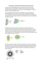
The conclusion that can be drawn from this investigation is that there is a significant relationship between temperature and distance from the CBD of Stourbridge. This suggests the presence of an urban heat island in Stourbridge’s CBD.
The experiment was not as accurate as it could have been, due to several factors, firstly change in weather conditions during the day; from a pressure chart is could clearly be seen that a front was moving over the area that morning. This may have affected the temperature making the results that were collected void. A better way to have conducted this experiment would have been to have twelve groups and stationed one group at each point and have got them to take the readings at the same time.
The set of results which are probably least accurate are the wind directions as due to very weak winds that morning it was very hard to tell which direction the wind was coming from. This could have been improved by either doing the investigation on a windier day are using digital equipment.