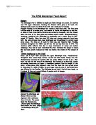
York is often under threat to
flooding because of its situation.
The river Ouse is the principal
drainage basin in Yorkshire.
The Ouse is formed by the
confluence of the Ouse, Gill,
Beck and the river Ure, a few
kilometres downstream of the
confluence of the rivers Swale and
Ure. The Ouse the flows southwards
and is joined by the Nidd just to
the north of York. The river Ouse
meets the river Foss directly in the
heart of the city centre. The tributaries
of the Wharfe, Derwent, Aire and Don
all join the Ouse further downstream
before it meets the Trent to become
the Humber Estuary.
Over many years the city of York has used many different tactics to protect the city from flooding. Some of which have worked and some have not. We went to York to look at the different flood prevention systems the council have tried to use. I looked at a number of different strategies that I could use if I was working for York council,
- Flood Walls
- Barrage
- Diversion Channel
- Levees
- Re-sectioning
- Flood warning systems
- Emergency relief
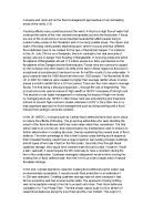
We have to think which area of the city needs most protection, this is the CBD, (central business district) and we also have to think about which strategies would work best in which place. I labelled my choices on a map on the following page.
A.
Where A is labelled on the map I decided to build levees, this is because there is a near by residential area which needs protection from the river. There are also fields surrounding this area so the floodwaters will be able to be held there until the river level has fallen. Since the levees are in a residential area I will cover them with grass so that they do not stand out and look silly.
B & E.
Location B is going to be the main flood prevention system. Here I am going to build floodwalls to protect the most expensive part of the CBD. The floodwalls will hold a huge volume of water so I have incorporated ings/flood fields so that this high volume of water can be safely disposed.
C.
I have chosen to invest money in early warning systems and forecasting equipment, I will put this equipment upstream so it will tell us when the river is likely to flood.
D.
Here I have provided emergency relief encase of a flood. I chose this are because it is right at the confluence of the Ouse and the Foss, this area is mostly likely to be one of the worst hit areas.
I think that if York installed all of the flood prevention systems in the places I have stated it would be a safer place in the time of a flood.