
"Exeter is dealing well with its traffic needs" Discuss.
The hypothesis for this piece of coursework is "Exeter is dealing well with its traffic needs" As shown in the maps on the previous page Exeter is a city in the south-west of England, with areas like Dartmoor which is a national park nearby, Exeter is also surrounded by towns and villages like Topsham, Exmouth, Starcross and Lympstone. At the moment Exeter's population is around 111,000 but is always growing. Exeter has many transport links, including two main train stations and a few more local ones, a successful bus service, many roads in and surrounding Exeter and an international airport. Exeter's main train stations are Central station which is a few minute walk to the city centre and St David's station which is a 15-20 minutes walk or a few minute bus journey. Exeter has more local train station such as St Thomas train station, but these unlike the two main train stations which have trains which travel all around the country only have trains which travel to closer towns or cities. Exeter's main bus service which is Stagecoach, has many routes which enables you to travel around and just past the outskirts of Exeter, Stagecoach also have a Main bus station in Exeter which also has less frequent buses which travel further to place all around England. The last transport link which Exeter has is Exeter's international airport which as well as flying chartered flights also

Cholera - its global impact
Cholera Cholera is an infectious disease caused by the bacterium Vibrio cholera, which usually spreads through contaminated water. It affects the absorption of water in the small intestine and in severe cases produces severe diarrhoea. The most dangerous aspect of Cholera is the immense loss of fluid that can occur within a few days. Without treatment within 24 hours of developing the disease, the loss of fluid can be fatal. Many cases, such as those in Zimbabwe, require hospitalisation of infected people so that fluids can be administered straight into the bloodstream with the use of a drip. Cholera bacteria occur naturally in coastal waters, where they attach to tiny crustaceans called Copepods. The Cholera bacteria travel with the Copepods, spreading worldwide as the crustaceans follow their food sources, which are certain types of algae and plankton. These grow rapidly when the water temperatures rise and algae growth is further increased by the urea found in sewage and agricultural runoff. Therefore most Cholera outbreaks occur in spring and autumn when ocean surface temperatures and algae blooms are at their highest. More algae mean more Copepods, and more Copepods mean more Cholera bacteria. The map on the left shows that the areas that Cholera is discovered in are situated below the Brandt line. This is because these areas are surrounded by warm oceans where the

The number of fatalities that result from volcanic and seismic natural hazards is related to the level of development in the country in which they occur. Discuss.
The number of fatalities that result from volcanic and seismic natural hazards is related to the level of development in the country in which they occur. Discuss. A natural hazard is an event, linked to the physical environment, which is considered to have a negative effect on humans. The event is also seen to be unpreventable by humans. However, an event such as a volcanic eruption that has no effect on human beings is considered a natural phenomenon rather than a natural hazard. It is the presence of humans, in an area that such an event occurs, that allows it to be termed a hazard. Although humans cannot prevent these occurrences, they have a role to play in the event's extremity as a natural hazard. For example, volcanic eruptions have been present throughout history, but it is not until settlements are built on the rich soils they form that they become a hazard. This essay I will evaluate the extent to which the level of development in a country affects the number of fatalities caused by volcanic and seismic natural hazards. A volcanic natural hazard is a volcanic eruption. Volcanoes are formed at convergent and divergent plate boundaries and also at hot spots. At convergent plate boundaries eruptions tend to be from a vent, as oceanic crust is forced beneath another plate, the extremities of heat and pressure leads to the partial melting of the crust which is being
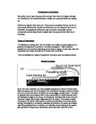
Temperature Inversions.
Temperature Inversions Normally, the air near the ground is warmer than the air at higher altitude. An inversion is the reverse situation--colder air at ground level than higher up. Cold air is heavier than warm air. Thus once an inversion forms, the air is very stable. Mixing that would normally occur by the rising of warm air is inhibited. Consequently pollutants such as carbon monoxide, sulphur compounds and ice fog remain trapped near the ground when there is an inversion. Types of Inversions The stability and mixing of air near the surface is controlled to a great degree by the presence of temperature inversions in the lower atmosphere. These inversions typically are very extensive, blanketing entire cities or regions. In each case, warm air is produced over a layer of cooler air in contact with the surface. There are basically four types of temperature inversions, each are explained below. Marine Inversions If you live near a coastline, you have probably experienced a marine inversion layer. Near cool oceans, such as in the western U.S. and Western Europe, a marine inversion can turn a hot summer day at the beach into a cool, foggy, overcast shiver. The ocean is typically quite cool compared with the land, particularly at middle latitudes where the heating by sunlight is not strong. Air sitting over cold water also tends to be cool. Moreover, a great deal of

Does the demographic transition model still provide a 21st century framework for looking at demographical change in countries which are experiencing development? To what extent is the tool really useful or should we make it obsolete?
Does the DTM still provide a 21st century framework for looking at demographical change in countries which are experiencing development? To what extent is the tool really useful or should we make it obsolete? The demographic transition model is a means to calculate how countries will move from having high birth and death rates to low birth and death rates. It should allow us to predict the stages a developing country will have to pass through before it is fully industrialised. These changes are dependant on an array of social and economic factors for instance improved education, changes to women's roles (e.g. emancipation), better diet and enhanced healthcare. The demographic transition model is the result of compiled data, such as, birth rate, death rate and population from industrialised countries (mainly Europe and America). The DTM consists of 5 sections; there were originally 4 stages but the 5th was recently added when countries that were already considered to be fully developed continued to develop and change, making it necessary to modify and update the model. In stage 1 birth and death rates fluctuate at a high level (about 35 per 1000) giving a small population growth. Stage 2 is characterised by high birth rates but rapidly falling death rate to about 20 per 1000 people giving a rapid population growth. In stage 3 birth rates fall rapidly, to about 16 per 1000

For my Travel and Tourism coursework I have chosen Marbella as my European destination
AO1 - Marbella Ronda is a beautiful town that lies within the Serranía de Ronda mountain range 48km away from Marbella at an altitude of 739 meters. The town is split into two different sections by a 100 meter deep gorge called El Tajo and is joined by the Puente Nuevo (which stands for New Bridge). The bridge was built in 1751 and took a total of 42 years to build; this is a key tourist attraction that brings many tourists to Ronda year in year out. Iglesia Mayor de la Encarnacion is a historical church in Marbella that was originally built in 1505, however most of the building was raised in 1712 and is now claimed to be the city's most important church which makes it popular for tourist visits. Alcazaba Wall (Marbella town's castle) and the 16th century town hall in the centre of town are two of Marbella's nicest buildings; these are opened up for visits and excursions and therefore help to attract more tourists to the area. Constitution Park, La Alameda Park and Arroyo de la Represa are three of Marbella's main local parks. Constitution Park which was once a garden of private residence is now used for concerts and plays throughout the summer whereas the Alameda Park and Arroyo de la Represa park are mainly used by the old Spanish locals and tourists to relax and talk in the quiet tropical gardens. For my Travel and Tourism coursework I have chosen Marbella as my

Discuss the relative importance of physical and human factors in accounting for changes to vegetation over time within ecosystems in the British Isles
Discuss the relative importance of physical and human factors in accounting for changes to vegetation over time within ecosystems in the British Isles The British Isles is an example of a Lithosere succession, in that it began as bare rock from glacial retreat. The plant succession started with the pioneer species which were algae and bacteria. Both began to broke down rock surface through weathering. Then lichens and mosses began growing in the area which helps with water retention and provides a base for soil. The next stage of primary succession is herbs/grasses/flowering plants/ferns. These add nutrients and organic matter to the ground which provided soil. Next, shrubs invaded and colonised the area. Shrubs dominate and shade out the sere below them. Small trees such as birch and willow were the following sere which invaded and colonised the area. They produced humus from leaf fall which provided nutrients for the soil through nutrient recycling and encouraged new growth of the sere. The last sere is the larger trees which are oak and ash which dominate the area and shade out smaller trees. This sere is the climax community in that it is stable and no further succession happens after. The climax community is the deciduous woodland biome we know today. The main characteristics include the location in which they are found, which is in temperate maritime climate such as

Investigating Travel & Tourism
Unit 1 - Investigating Travel & Tourism Table of Contents UNIT 1 - INVESTIGATING TRAVEL & TOURISM 1 TABLE OF CONTENTS 2 E1 KEY POST-WAR DEVELOPMENTS 5 . The changing social economic circumstances 7 2. Technological developments 7 3. Product development and innovation 7 4. Changing consumer needs and expectations and fashions 7 E1 CHANGING SOCIAL ECONOMIC CIRCUMSTANCES 8 . Increase in Leisure Time 8 2. Disposable Income 9 3. Car Ownership 10 E1 TECHNOLOGICAL DEVELOPMENTS 11 2. Communication and information systems 12 3. Product Development 12 E1 FEATURES OF THE TRAVEL AND TOURISM INDUSTRY 14 E1 FEATURES OF THE TRAVEL AND TOURISM INDUSTRY 14 The National Tourist Boards (NTB's) 15 The Voluntary Sector 16 New Technologies 16 External Pressures 16 Currency Fluctuation 16 Legislation 17 Climate Change 17 Natural Disasters 17 War, Acts of Terrorism 17 Impact on Host Communities 17 Economic 18 Social 18 Environmental 18 E2 - SCALE OF THE UK INDUSTRY AND ITS ECONOMIC SIGNIFICANCE 20 Business Tourism 22 E2 - SCALE OF THE UK TRAVEL AND TOURISM INDUSTRY 23 Travel and Tourism Revenue 23 Contribution to the Balance of Payments 23 E2 - SCALE OF THE UK INDUSTRY AND ITS ECONOMIC SIGNIFICANCE 25 E3 A FULL EXPLANATION OF THE PRESENT STRUCTURE OF THE INDUSTRY 26 . Accommodation and Catering 27 Serviced Accommodation 27 Self Serviced Accommodation

With reference to a named country, evaluate attempts to manage population change
With reference to a named country, evaluate attempts to manage population change (15 marks) Thailand is located in south-east Asia, It is bordered to the north by Burma and Laos, to the east by Cambodia and to the south by the Gulf of Thailand and Malaysia. Mechai Viravaidya was a key influence in the change of population policy in Thailand, he came into government in 1973; he recognised that the fertility rate at the present time was not sustainable. In 1974 he set up the PDA or Population Development Association. It is arguable that at this time that Thailand was an LEDC where as now it is more commonly referred to as a Newly Industrialised Country (NIC), the faster transition through the demographic transition model may be a result of the change in population control. It was Mechai Viravaidya's plan to promote the use of contraception (formerly seen as a taboo subject) and family planning in order to control population development. The threat of Aids and HIV also became apparent to Viravaidya and the government; this gave him fresh impetus for his scheme. There were many successes of the program; this was attributable to a number of factors. Mechai's creativity helped to gain support such as free drinks after a vasectomy. This coupled with the willingness and openness of the Thai people allowed new ideas to thrive. The government gave Mechai the resources and support he

Comparison Between MEDC and LEDC
Comparison Between MEDC and LEDC The comparisons between MEDC- More Economically Developed Country and LEDC-Less Economically Developed Country are many and varied but are mainly related to finance which gives the MEDC a higher standard of living for its occupants than those of the LEDC. Geographically most MEDC are situated in the northern hemisphere were as the LEDC are mostly in the southern hemisphere. Most MEDC are well advanced or have completed their development period for example the United Kingdom were as the LEDC are still in the early stages. Development of a country can be shown in a demographic transition model; this model consists of four stages. Stage one is pre modern which is when the birth rate and death rate fluctuate between each other which keeps population at a low, but stable point. Next is urbanizing and industrializing, at this stage the death rate drops due to better health care, standard of living etc and causes the population to increase quite quickly. Stage three is called mature industrial in this phase the birth rate stays high and the death rate is low so the population still increases quickly due to better technology. Lastly is the post industrial stage where the birth rate drops to the same level as the death rate which causes the population to become steady once again. An MEDC would be in stage four or nearing the end of it where and LEDC


