Research on China's population. The name of article is Chinas days of one-child only may be ending which was written by Jane Macarthney. It was published in The Weekend Australia, March 20-21, 2010.
Summary The name of article is 'China's days of one-child only may be ending' which was written by Jane Macarthney. It was published in The Weekend Australia, March 20-21, 2010. Macarthney got the information from the Southern Weekend newspaper in Guangzhou and also from some government officers. The main topic of this article is the experiment with the two children policy conducted in Yicheng, China. The Chinese government implemented two children policy in Yicheng which is southwest of the capital, 25 years ago in order to see whether there would be population explosion. The reason for choosing Yicheng is that it is a typical farming. The people with certain conditions can have maximum two children. However, the test had some strict rules such as men in Yicheng cannot marry until they are 25; women should not before 23 year-old. Additionally, the gap between first child and second kid has to more than 6 months; otherwise, the couples need to face 1200yuan fine. As a result, according to a government official said, in 2000, the population in Yicheng was 310,000 is a little higher than the government prediction. A doctor pointed out that some people in the country still want to have one child. The famers prefer to have two children in order to share the farmwork or other work. However, in town such as Shanghai, government encourages couples who are both sole children to
Ethics of Wind Farms Erected at the Scarborough Bluffs
Wind farms are widely recognized as the new movement of change for power supply, which is taking place around Ontario for a greener environment. Lately, there have been heated debates between the citizens of Scarborough and the government of Ontario regarding the idea of putting up a wind farm at the Scarborough Bluffs. Nevertheless, it is obvious wind farms should not be erected at the Scarborough Bluffs if one was to evaluate the advantages and disadvantages of the situation at hand. Through a thorough investigation on wind turbines and the Scarborough Bluffs, it is evident that there are many reasons to assemble a wind farm, although the consequences of the ruined Bluffs and the complications of wind generators overpower these reasons. Wind farms are a large grouping of wind generators or wind plants, which are located at a site with strong, dependable winds. Wind generators are machines which convert wind into energy from the current of wind hitting the rotor or the blades. They are usually considered to be a leading source for a greener economy or environment. This is the movement which is taking place for the future. According to this movement, the future is destined to be green because there will be no more greenhouse gases and the goal is to inevitably stop global warming all together. The Scarborough Bluffs is a high steep bank which is the result of erosion from
An Investigation of Channel and Stream Characteristics For Streams on the Isle of Arran
An Investigation of Channel and Stream Characteristics For Streams on the Isle of Arran Aims To investigate hypothesis associated with increasing distance down stream for streams on the Isle of Arron. Objectives To set up and test hypothesis To investigate how channel characteristics change with increasing stream order. Hypothesis . As the river progresses downstream the bedload decreases in size. 2. The bedload becomes rounder in shape downsream. 3. The width will increase in size as the river goes downstream towards the mouth of the river. 4. The velocity of the river will decrease as it goes downstream. 5. The depth will increase in size as it goes downstream. 6. The discharge will also increase as it goes downstream. Theory There are three processes by which material is transported from land to the sea (via rivers) these are: i) Weathering-physical and chemical breakdown of rocks. ii) The slope-the products of wethering are moved down the gravity gradient in mass movements by the slope wash processes. iii) Fluid transfer-water, air and ice. The load, carried by natural streams, can be separated into three compounds. The material carried by the river is called the rivers load. It comes from river erosion and weathering of the river banks. Especially when the river is bankfull, considerable quantities of load can be carried. The total amount

Kobe, Japan (Case Study)
Kobe, Japan (Case Study) Japan is positioned on the margin of the Eurasian Plate. The Philippine Sea Plate is subducted below the Eurasian plate, resulting in Japan having greater than average seismic and volcanic activity. Immediately south of Osaka Bay is a fault called the Median Tectonic Line, and it was sudden movement along this fault that triggered the earthquake that hit Kobe. Kobe is located farther than many other cities in Japan from the dangerous intersection of three tectonic plates: the Pacific, Eurasian, and Philippine. This triple junction is a junction of three compressive subduction zones. There had been a subduction fault that had already been broken in great earthquakes in 1944 and 1946. Kobe is also somewhat off the Median Tectonic Line, a zone of strike-slip faults. At 5.46am on January 17th 1995, whilst many of its people of Kobe were still asleep, the Japanese city of was hit by the largest earthquake in Japan since 1923. The earthquake was not only powerful (Richter scale 6.9 ), but with the epicenter only 20km southwest of the city, it resulted in massive damage to property and loss of life. The worst effected area was in the central part of Kobe, a region about 5km by 20km alongside the main docks and port area. This area is built on soft and easily moved rocks, especially the port itself which is built on reclaimed ground. Here the ground

To what extent can the principle of sustainability guide land use policy development
To what extent can the principle of sustainability guide land use policy development? The idea of developing in such a way that the present can meet their needs without future generations needs being compromised is not a new one. It has been practiced and continues to be practiced by many groups of people across the world. For example, this principle is embedded in Aboriginal beliefs that they come from the land, and must return to the land and so must be custodians to the land. The Brundtland Commission, chaired by the Norwegian prime minister, brought the concept to the foreground where the famous definition of sustainability was given. This essay will discuss the idea of sustainability, how the principle first emerged in policy, and what potential it has in the future development of land use policy. As the basis of all human activity, land is important in achieving sustainability and as such it is essential to focus on the planning and regulation of land use change. However, in order for this to take place the objectives of a policy must be certain before it can be implemented. Some people would argue that there is no need for government as market forces will lead to the best outcome in terms of total welfare. This has led to sustainability as a principle being described as a 'problem'1 which conflicts with such short term purely economic views. It is also said
The famous "one child policy" is one of the causes of overpopulation in China. One child policy not only did not solve the problem of overpopulation, but also cause other problems such as ageing population.
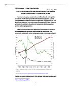
"They say that the birth of a new child should be the decision of the individuals involved, not the government." Do you agree with this view? Being the most populous country in the world, China has a the total population of 1.2 billion1, which makes up one-fifth of the world's total population. China is overpopulated due to insufficient resources to support such a big population size. The famous "one child policy" is one of the causes of overpopulation in China. One child policy not only did not solve the problem of overpopulation, but also cause other problems such as ageing population. China has been communist since 1949 and the Chinese communist regime was not concerned about the population limitation during that period of time. They maximize the population for military and strategic strength. This is shown in figure 1. The birth rate remains high during early 1950s. However, at the same time, there were politically generated agricultural production problems. This resulted in famine. Resources were not enough to support the sudden increasing population, which leads to overpopulation. As shown in figure 1, the death rate is continuously increasing during late 1950s and early 1960s. This is due to the failure of Great Leap Forward, which is a policy of speed up the country's industrialization and rural modernization. During that period of time, farmers were forced to

Investigate the rate of which lava flows down the side of a volcano and what affects the rate of which it flows.
Lava Flow Aim My aim is to investigate the rate of which lava flows down the side of a volcano and what affects the rate of which it flows. Planning In this investigation there are many different variables these are; * Angle of slope * Surface of volcano * The amount of lava * The temperature of the lava * The environmental conditions * The viscosity of the lava * How far it has to flow * The force of the eruption I have decided to investigate the angle of the slope because I will be doing the investigation in a school lab. So I will not be able to use real lava or a real volcano so I will use golden syrup instead of lava and a tile instead of a volcano slope. I also think that it will be easiest to set up and get accurate results. I predict that the higher the angle of the slope the faster the lava will flow down the slope. I have made this prediction from my scientific knowledge. I think this because the higher the angle gets the more gravitational potential energy (GPE) will be acting on the lava. So what is GPE well it is a type of energy that is stored in an object because of its height through which it has been lifted against the force of gravity. If it falls down we know that it has got gravitational potential energy. So it will be forced down the slope at a higher force. GPE is linked to kinetic energy. GPE that is acting on the lava can make it move

Do the benefits of using fertilisers for improving Plant productivity outweigh the implications To the environment?
Do the benefits of using fertilisers for improving Plant productivity outweigh the implications To the environment In my point of view I think that fertilizers are of use to the environment in some ways but can also be potentially damaging in others. The term fertilisers is stated as " A substance usually added to soil to increase its ability to support plant growth" by Encarta. This shows that fertilisers are needed to keep soil in good conditions to allow the maximum productivity for plant growth. This is why they are important to the agricultural industry because they allow maximum productivity and higher yields, meaning more money for the farmer. But fertilisers can also be potentially hazardous to the environment; they can pollute local water supplies, harm humans and animals and can add to the amount of volatile gases being added to the atmosphere. Firstly fertilizers are potentially good for the environment in ways that they improve the soil structure and nutrient content, this therefore improves plant growth. Fertilisers are needed to allow a farmer to have maximum productivity in the crop that they are growing. So they are vital for economic reasons to allow the most productivity the land can give, (high yield) so the most money can be got from selling the high yield amount of crops. Also fertilisers help the condition of the plants to be top condition by

Where is the Amazon Rainforest, ie its country and continent?
AMAZON QUESTIONS LOCATION AND PHYSICAL GEOGRAPHY Where is the Amazon Rainforest, ie its country and continent? The Amazon is one of the world's great rainforests. The Amazon river runs 3,000 miles from the Andes to the sea, and is longer than any river but the Nile. The vast Amazon basin covers more than two and a half million square miles, more than any other rainforest. The Amazon spreads across much of South America. Colombia, Ecuador, Peru, Bolivia, Brazil and Venezuela all have Amazonian regions. 2 How big an area does it cover? The amazon rainforest covers approxiamately 1.2 billion acres. This would be able to cover britain many times over. 3 What is the area's physical geography, eg climate and relief? The amazon is a wet, green land rich in plant life. The tropical climate is tempered by the heavy rainfall (exceeding 150 in./381 cm annually in parts of the upper and lower regions) and by high relative humidity. The Tropical Rainforest is a forest occurring in tropical areas of heavy rainfall. It is abundant with many species of wildlife and vegetation. Rainforests cover less than two percent of the Earth's surface. They are home to some 50 to 70 percent of all life forms on our planet. Rainforests are the most productive and most complex ecosystems on Earth. The tallest trees and are usually over 50 metres tall. The Kapok tree is an example of one of these.
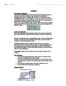
Limestone and it history
Limestone The formation of limestone Lime stone is a sedimentary rock made of dead animal shells formed deep down in the ocean; limestone also contains a large amount of calcium carbonate. Carboniferous limestone is a different type of limestone. It was formed around 350,000,000 years ago as a marine deposit in a warm, clear, shallow sea. The rock is well bedded and jointed. The cracks that separate the beds are called bedding planes and those that run down through the rock are called joints. Chalk is also a type of soft porous white limestone. Chalk is found mostly in England, a good example of this is the white cliffs of Dover or the motorway cutting at Blue Bell Hill, in Kent. Erosion and weathering Scree: lime stone tends to erode along the joints due to freeze thaw, this causes the parts to break off and fall to the bottom of the rock face to join the rest of the scree. Terraces: Limestone terraces are exposed bedding planes. Terraces are formed when limestone is eroded along joints and bedding planes on the scarp slope. Blocks of limestone are removed leaving the terracing. Limestone pavements: Where limestone outcrops at the top a hill, limestone pavements will form. The surface of the pavement is an exposed bedding plane and the exposed joints become widened, to form grykes, the blocks of limestone that remain between the grykes are called clints. Acidic


