Directions (Manchester to Blackpool)
Following motorways to get to Blackpool from major cities like Manchester is pretty easy. To venture this trip you have to firstly start at the M62, then you will have to turn off at junction 17, and follow until you reach the M60.after a period of time on this motorway you will reach the M61, which by keeping left will lead you on to the M55 and then exit by signs what lead to Blackpool. This trip will take approximately 1 hr and 5minutes, and about 55 miles.
As shown in these directions (above) traveling to Blackpool is easy because the majority of motorways connect to each other leading to a major town or city.
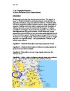
More cities are shown in (Fig 1.2)
Fig 1.2
Fig 1.2 shows many other major cities and how far some tourist may have to travel to get to this seaside resort.
From this information collected people living in London have to travel a very long distance to get to blackpool, this would then suggest that there maybe a low population of Londoners ,and many of them will be staying in hotels. However to cities such as Liverpool the driving time to Blackpool is low which means the majority of them will be going to Blackpool for basic day trips.
Ferry trips are also available to a variety of places in Ireland over the Irish Sea, meaning many Irish tourists will stay in hotel, like tourist from London.
The Burgess Model
Fig 1.3
The Burgess model is based on the theory that in each town or city it is separated into areas of quality and difference. In the burgess model it is separated into 5 different zones which represents an area in the city, each area has its own characteristics from the next one. When looking at a burgess model you can compare any city in the world and see if it follows the same rule for example if it’s a typical city. Looking at (Fig 1.3), from middle (coded blue), and the yellow outward each section is named differently and will have its purpose in a typical city.
-
The first zone coded blue is known as the CBD (The Central Business District) this is an area densely populated with many commercercial shops and businesses. In this area recreational facilities are found such as shopping centres, and cinemas, with easy assessable routes to get in and out of the city. The building here usually are high value because the land here is under competition all the time. Competition is high here because this is where the majority of money is in the city; in addition the most successful businesses are in this type of area. Many buildings here are very tall (for example skyscrapers) because statistics show it is a lot cheaper to build upward, rather than building outwards what takes up a lot of space. Land here is so expensive which explains why these areas are sparsely populated with home owners.
-
the second zone coded red is known as the Transition Zone, This zone has cafes ,car parks etc.these areas usually are adapted to people who want to live closer to the CBD and flats and apartments are built for this purpose. The original buildings in this district are usually old; this is why flats are built in replacement. However in this zone you can also find large companies because of the price of land will be cheaper. The transition zone also has a few terraced houses what are not yet been knocked down because of residents still living there. In my opinion this zone can be named the ‘in-between zone’ because of the mixture of companies and houses.
-
The third zone coded light green is known as the Lower class residential (inner city) a short description of this is by saying is a residential area near the city, this area is mainly made up into flats, terraced houses, and estates which usually consist of council houses. This area was once used for industry and terraced housing was usually the home for many workers. However in recent times the area is gradually being developed, which means terraced houses from the 19th century are decreasing at a quick rate.
-
The forth zone coded purple is known as the Medium class residential (inner suburbs). The inner suburbs are mainly built up of residential areas. Many of the buildings here were built in the period around 1920-1945 and are mainly in a semi detached nature. In this are there are bus stops where people can travel to the CBD for work and enteretainment.In this area there is a small amount of shops for local residents this is because most shops here won’t make much money compared to shops in the CBD, which means building here is much easier for people, however income is low.
-
The fifth zone coded yellow is known as the High class residential (outer suburbs). This area consists mainly of modern (post war houses) and a variety of council housing estates. In addition to this are can be used to build golf courses and for agriculture because of the free land space and the less competition. Living in this zone is ideal for workers that work near the CBD because transport services are acceible.land value is low however because of the high areas of open space houses may be more expensive.
The Distance Decay Model
Fig 1.4
The Distance Decay model is the theory that the highest bidders will receive the best land. Shops and offices can afford high land values because they are based in the CBD; an example of a shop is Marks and Spencer.
Seen on Fig 1.4, as you move along the distances axis, the price lowers of land, and not as valuable.
The next section is the transition zone which is represented as industry, because all of factories are to be seen in these areas. Industry cannot afford the highest land compared to the CBD, this is because they need large areas of land can can’t afford it. It is also obvious that the land is less attractive here and not many big roads.
At the end of this model it is represented as residential this is where the land value is at its lowest compared to the CBD, this is mainly because of less competition. This shows that it is more expensive to rent as an industrial business man than it is to buy a house
The Seaside Model
Fig 1.5
Key
-
- RBD (Recreational Business District)
- - Large Hotels
-
– Small hotels/B&B
- – CBD
- –Inner City(low class residential)
- –Medium class residential
- -High class residential
The seaside model can be explained by Fig 1.5.this is the theory that along the sea front there are the main attractions on a seaside town. This area along the seafront is called the RBD (Recreational Business District).
Along the sea front there are large hotels and businesses which explains where the economy is being put in blackpool.east from here is where we see slight changes in that there are a small variety of small hotels and B&Bs, however there was only one large hotel here which wasn’t as well kept as the ones on the seafront.
In the middle of the model there is the CBD (The Central Business District), this is where main roads are found, and the main transport service routes to the seafront. In this area we saw a lot of small shops, which explains why there is a residential area after this.
In the main residential area this is where the majority of people in Blackpool live, and permanently stay, these areas are usually quiet.