Seismograph is another term used for seismometer, though it is more applicable to the older instruments in which the measuring and recording of ground motion were combined than to modern systems, in which these functions are separated. Both types provide a continuous record of ground motion; this distinguishes them from seismoscopes, which merely indicate that motion has occurred, perhaps with some simple measure of how large it was.
Inertial seismometers have:
A mass, usually called the inertial mass, that can move relative to the instrument frame, but is attached to it by a system (such as a spring) that will hold it fixed relative to the frame if there is no motion, and also damp out any motions once the motion of the frame stops.
A means of recording the motion of the mass relative to the frame, or the force needed to keep it from moving.
Any motion of the ground moves the frame. The mass tends not to move because of its inertia, and by measuring the motion between the frame and the mass the motion of the ground can be determined, even though the mass does move.
Early seismometers used optical levers or mechanical linkages to amplify the small motions involved, recording on soot-covered paper or photographic paper.
The Richter magnitude scale, or more correctly local magnitude ML scale, assigns a single number to quantify the amount of seismic energy released by an earthquake. It is a base-10 logarithmic scale obtained by calculating the logarithm of the combined horizontal amplitude of the largest displacement from zero on a Wood-Anderson torsion seismometer output. The effective limit of measurement for local magnitude is about ML=6.8. The energy release of an earthquake scales with the 3/2 power of the shaking amplitude, and thus a difference in magnitude of 1.0 is equivalent to a factor of 31.6 in the energy released; a difference of magnitude of 2.0 is equivalent to a factor of 1000 in the energy released.
The Richter magnitude of an earthquake is determined from the logarithm of the amplitude of waves recorded by seismographs (adjustments are included to compensate for the variation in the distance between the various seismographs and the epicenter of the earthquake). Because of the logarithmic basis of the scale, each whole number increase in magnitude represents a tenfold increase in measured amplitude; in terms of energy, each whole number increase corresponds to an increase of about 31.6 times the amount of energy released.
Events with magnitudes of about 4.6 or greater are strong enough to be recorded by any of the seismographs in the world.
The following describes the typical effects of earthquakes of various magnitudes near the epicenter. This table should be taken with extreme caution, since intensity and thus ground effects depend not only on the magnitude, but also on the distance to the epicenter, the depth of the earthquake's focus beneath the epicenter, and geological conditions (certain terrains can amplify seismic signals).
The epicenter or epicentre (ancient Greek: επίκεντρον) is the point on the Earth's surface that is directly above the hypocenter or focus, the point where an earthquake or other underground explosion originates.
Seismic waves propagate spherically out from the hypocenter. After an earthquake has occurred, geologists can find out where the epicenter was located by triangulation of seismographic data from three or more different locations. Seismic shadowing occurs on the opposite side of the Earth from the earthquake epicenter because the liquid outer core absorbs the transverse or shear waves (S-waves), and refracts the longitudinal or compressional (P-waves).
The epicenter is usually the location of greatest damage. However, in some cases the epicenter is above the start of a much larger event. In these cases, damage may be spread across a larger area with the greatest damage possibly occurring some distance from the epicenter. For example, in the magnitude 7.9 2002 Denali Fault Earthquake in Alaska, the epicenter was at the western end of the rupture, but the greatest damage occurred about 330 km away at the eastern end of the rupture zone.
Plate tectonics is a theory of geology that has been developed to explain the observed evidence for large scale motions of the Earth's lithosphere. The theory encompassed and superseded the older theory of continental drift from the first half of the 20th century and the concept of seafloor spreading developed during the 1960s.
The outermost part of the Earth's interior is made up of two layers: above is the lithosphere, comprising the crust and the rigid uppermost part of the mantle. Below the lithosphere lies the asthenosphere. Although solid, the asthenosphere has relatively low viscosity and shear strength and can flow like a liquid on geological time scales. The deeper mantle below the asthenosphere is more rigid again. This is, however, not because of cooler temperatures but due to high pressure.
The lithosphere is broken up into what are called tectonic plates — in the case of Earth, there are seven major and many minor plates (see list below). The lithospheric plates ride on the asthenosphere. These plates move in relation to one another at one of three types of plate boundaries: convergent or collision boundaries, divergent or spreading boundaries, and transform boundaries. Earthquakes, volcanic activity, mountain-building, and oceanic trench formation occur along plate boundaries. The lateral movement of the plates is typically at speeds of 5 - 10 cm/yr.
A tsunami is a series of waves created when a body of water, such as an ocean, is rapidly displaced. Earthquakes, mass movements above or below water, volcanic eruptions and other underwater explosions, landslides, underwater earthquakes, large meteoroid or asteroid impacts and testing with nuclear weapons at sea all have the potential to generate a tsunami. The effects of a tsunami are always devastating due to the immense volumes of water and energy involved.
The term tsunami comes from the Japanese meaning literally harbor wave.
The Greek historian Thucydides was the first to relate tsunamis to submarine quakes,but understanding of the nature of tsunamis remained slim until the 20th century and is the subject of ongoing research.
Many early geological, geographic, oceanographic etc; texts refer to "Seismic sea waves" - these are now referred to as "tsunami."
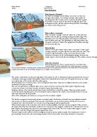
A tsunami can be generated when converging or destructive plate boundaries abruptly deform and vertically displace the overlying water. Such large vertical movements of the Earth's crust can occur at plate boundaries. Subduction zone related earthquakes are particularly effective in generating tsunami. A tsunami in the 1940's that inundated Hilo, Hawaii, was caused by an earthquake on one of the Aleutian Islands in Alaska. That earthquake was 7.8 on the Richter Scale. The area concerned is where the Pacific Ocean floor is subducting (or being pushed downwards) under Alaska.
Examples of tsunami being generated at locations away from convergent boundaries include - Storegga, Grand Banks 1929, Papua New Guinea 1998 (Tappin, 2001). In the case of the Grand Banks and Papua New Guinea tsunamis an earthquake caused sediments to become unstable and subsequently fail. These slumped and as they flowed down slope a tsunami was generated. These tsunami did not travel transoceanic distances.
It is not known what caused the Storegga sediments to fail. It may have been due to overloading of the sediments causing them to become unstable and they failed solely as a result of being overloaded. It is also possible that an earthquake caused the sediments to become unstable and then fail.
Cascadia Earthquake
The 1700 Cascadia Earthquake was a magnitude 8.7 – 9.2 megathrust earthquake that occurred in the Cascadia subduction zone in 1700. The earthquake involved the Juan de Fuca Plate underlying the Pacific ocean, from mid-Vancouver Island in southwest Canada off British Columbia to northern California, along the Pacific Northwest coast. The length of the fault rupture was about 1000 kilometers (600 miles) with an average slip of 20 meters.
The Cascadia Earthquake caused a tsunami that struck the coast of Japan, and may also be linked to the Bonneville slide.
Evidence supporting the occurrence of the 1700 earthquake has been gathered into the 2005 book, The Orphan Tsunami of 1700, by geologist Brian Atwater and others.
The evidence suggests that it took place at about 9:00 PM on January 26, 1700. Although there were no written records in the region at the time, the earthquake's precise date is nevertheless known from Japanese records of a tsunami that has not been tied to any other Pacific Rim earthquake. The most important clue linking the tsunami in Japan and the earthquake in the Pacific Northwest comes from studies of tree rings (dendrochronology) which show that red cedar trees killed by lowering of coastal forests into the tidal zone by the earthquake have outermost growth rings that formed in 1699, the last growing season before the tsunami. Oral traditions also exist among the region's original inhabitants, although these do not specify the date.
Hawaiian eruption
A Hawaiian eruption is a type of volcanic eruption where lava flows from the vent in a relative gentle, low level eruption, so called because it is characteristic of Hawaiian volcanoes. Typically they are effusive eruptions, with basaltic magmas of low viscosity, low content of gases, and high temperature at the vent. Very little amount of volcanic ash is produced. This type of eruption occurs most often on hotspot volcanoes such as Kilauea, though it can occur near subduction zones (e.g. Medicine Lake, California.) Hawaiian eruptions are usually the most attractive to tourists and are the safest because there is little danger from ash.
Hawaiian eruptions may occur along fissure vents, such as during the eruption of Mauna Loa Volcano in 1950, or at a central vent, such as during the 1959 eruption in Kilauea Iki Crater of Kilauea Volcano, Hawaii, which created a lava fountain 580 meters (1,900 feet) high and formed a 38 meter cone named Puu Puai. In fissure-type eruptions, lava spurts from a fissure on the volcano's rift zone and feeds lava streams that flow downslope. In central-vent eruptions, a fountain of lava can spurt to a height of 300 meters or more (heights of 1600 meters were reported for the 1986 eruption of Mount Mihara on Izu Ōshima, Japan).
Hawaiian eruptions usually start by formation of a crack in the ground from which a curtain of incandescent magma or several closely spaced magma fountains appear. The lava can overflow the fissure and form aa or pahoehoe style of flows. Eruptions from a central cone can form small lightly sloped shield volcanoes, for example the Mauna Ulu. When globules of lava are thrown into the air, they are often still fluid when it impacts the ground, flattening into "cow-dung bombs."
An earthquake-proof building must be built with a few innovations discovered in the second half of the 20th century. The first innovation is isolated base technology. This involves using a coil or other flexible support and placing it between the structure and the foundation of the building. This system counteracts the motion of the seismic waves. As the earthquake moves the foundation one way, the support moves the other way, and the building stays nearly completely stationary. Another feature of modern buildings is the use of cross-supports in between the frame supports, or between the corners of the frame. These supports hold the structure together during an earthquake.No building, however, can be made 100% safe and building earthquake proof structures to be more effective is just trial and error
The use of fire-proof materials in construction is safer because there are many fires when earthquakes occur because gas pipelines shake and can cause explosions.
A building's strength also has to do with the material of which it is composed. Most modern buildings use steel alloys, but concrete is sometimes used for smaller buildings. If one designs a building out of steel but does not utilize the materials correctly, that member will make just as weak a building as a building made out of wood. The use of materials is a critical aspect of a building; it will determine whether a building will withstand an earthquake.
During the violent shaking of a high-magnitude earthquake, an outrigger will support the structure. If the structure begins to fail, the outriggers will hold up the structure. The problem with an outrigger system is that if an outrigger were to fail from the force of a collapsing building, the damage would increase outside the perimeter of the building as the outrigger fell outwards. outriggers must be employed selectively because of their potential disadvantages.
For example: Transamerica building San Francisco