Intro
Aims
* To investigate what patterns the river Allt Doire Nan Eun shows for wet water depth, water velocity and pH in its three courses.
* To investigate whether the river shows textbook characteristics for erosion and deposition in a river channel.
* To investigate how rock roundness and moss coverage changes downstream and at different points across a channel.
Location
During the course of this geography field trip my group set out to investigate the aims stated above. To do this we travelled to Scotland. Once there we stayed at the Kindrogan Field Centre in Enochdhu, Blairgowrie, Perthshire near Pitlochry.
Why was this Site Chosen?
We studied the river Allt Doire Nan Eun firstly because of the fact that each of its three courses were fairly close to each other due to the relative shortness (meaning that we could travel from one to the next quickly and therefore collect results from each of the three sites- upper, middle and lower course- within a day) and secondly because it was conveniently within easy walking distance from the field centre.
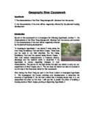
Were there any Signs of Human Impact?
As can be seen in the two pictures above, some parts of the river, especially in the upper course, are very close to the road (within 10 meters at some points); this meant that the natural formation of the land surrounding the river had been altered, which could have been a cause of the off-neutral pH of the river water. It would also mean that more water would drain into the river because of the impermeable road material. Finally, the river was located inside land that was being used to raise cows; the constant trampling of the cows through the river and the surrounding environment could be considered as a human impact.
Aims
* To investigate what patterns the river Allt Doire Nan Eun shows for wet water depth, water velocity and pH in its three courses.
* To investigate whether the river shows textbook characteristics for erosion and deposition in a river channel.
* To investigate how rock roundness and moss coverage changes downstream and at different points across a channel.
Location
During the course of this geography field trip my group set out to investigate the aims stated above. To do this we travelled to Scotland. Once there we stayed at the Kindrogan Field Centre in Enochdhu, Blairgowrie, Perthshire near Pitlochry.
Why was this Site Chosen?
We studied the river Allt Doire Nan Eun firstly because of the fact that each of its three courses were fairly close to each other due to the relative shortness (meaning that we could travel from one to the next quickly and therefore collect results from each of the three sites- upper, middle and lower course- within a day) and secondly because it was conveniently within easy walking distance from the field centre.
Were there any Signs of Human Impact?
As can be seen in the two pictures above, some parts of the river, especially in the upper course, are very close to the road (within 10 meters at some points); this meant that the natural formation of the land surrounding the river had been altered, which could have been a cause of the off-neutral pH of the river water. It would also mean that more water would drain into the river because of the impermeable road material. Finally, the river was located inside land that was being used to raise cows; the constant trampling of the cows through the river and the surrounding environment could be considered as a human impact.