What are the main functions of Castleton and Bradwell and how do they differ from each other?
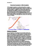
Aim 1 Aim one was to answer the question: What are the main functions of Castleton and Bradwell and how do they differ from each other? In order to come to a conclusion answering this question I will now present and analyse the relevant results and information that I have researched in this section. What is the main function of Castleton? Parking Survey I want to discover the main function of Castleton. Firstly I conducted a parking survey. I counted the total capacity of the public car parks. Castleton had: Large Car Park, Capacity: 76 Cars, 17 Coaches (Public Car Park on the Castleton Map) Small Overflow Car Park, Capacity: Approximately 20 Vehicles This is a very large capacity for parking considering that the Castleton Parish has a population of only 689, and that many houses in the village have parking facilities included. This would therefore suggest that the car parks are needed for visitors and hence that Tourism is a prominent industry in the village. This suggestion is further evidenced by the presence of both a small overflow car park and specialist parking facilities for coaches because these facilities would not be provided if they were not needed. The specialist coach spaces are provided so that large groups of tourists can visit at the same time and the overflow car park would be needed at particularly busy times of the year such as during the months of

my school enviroment plan
My School environment plan Its important Ousedale School has an environmental plan as I am seeing more and more rubbish and litter appearing everyday. I am sure if this carelessness of the students continues we will start to experience rats and the litter will rot making the school a safety hazard-which none of us want. As a world we are ok in recycling but we could improve so beginning at Ousedale School is a start. My aim for this plan is to reduce the amount of litter lying about the school. I did some surveys and found out that the most litter is outside the two canteens [upper and lower] and I think these are because of the lack of bins around school. So I think that in both canteens we should have more bins outside and inside them, maybe also stop using disposable plates and cutlery but then there would be the washing up after and dishwashers cost money. The only people really who can stop litter in or near the canteens is the students. In classrooms we can do a lot of things to make our school greener. For instance every classroom should have a recycling bin for paper as well as a normal bin for litter. Also to save energy we should make sure we turn off the lights in unused classrooms and in the summer instead of using fans to cool our selves down with should just open the windows. Just doing little things like that is a big start in helping the environment. I
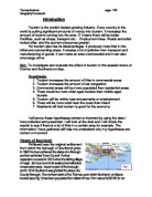
Bridlington is located on the north - eastern shore of England, as shown on my map of Bridlington.
Introduction Bridlington is located on the north - eastern shore of England, as shown on my map of Bridlington. I have used a map to help me explain what I have written about the location of Bridlington. Bridlington is located close to Sewerby and Flamborough. It is situated on the east Yorkshire coast, 30 miles north of Hull and 40 miles east of York. (you can see all of this on my map.) Bridlington's famous for it's award winning beaches with their miles of golden sands, a sparkling sea to swim, splash or paddle in, the Edwardian promenade and the funfair. In the mid - seventeenth century Bridlington quay depended on a flourishing sea bourn trade as the town emerged as a seaport. Bridlington (the old town) continued to depend on it's market and the provision of goods and services both to the town and nearby countryside. Taking a look back at Bridlington quay in the mid - seventeenth century it is fairly certain that Henry Vlll built a fort to protect shipping in the bay as there is evidence of it's demolition by 1650. A new fort with moat, drawbridge, defensive bank, stockade and cannon were built near the seaward end of fort terrace complete with a military garrison. This defence of the town was necessary in view of the conflict of trade and shipping between England and the Netherlands resulting in the Anglo - Dutch wars. Any history of the harbour at this time must take

How have changes in tourist patterns in recent years affected a named resort in the MEDC?
How have changes in tourist patterns in recent years affected a named resort in the MEDC? Tourism has changed dramatically in recent years, due to the improvements in technology of transport which have gotten faster and more efficient, allowing people to even travel hundreds of miles abroad which before the invention of the plane would have been only for those in the army, explorers or the unbelievably wealthy whereas today flights on planes can be bought very cheaply and people have a greater amount of free time which can be spent on holiday because of paid holiday leave, earlier retirement, increases in awareness of other cultures and countries through the media which often have a more reliable climate than of local holiday destinations. Tourists used to mainly travel to more traditional holiday destinations like the countryside or sea side resorts, for example Blackpool, which have struggled to survive against competition from foreign holidays which are seen as more interesting and exciting. In modern times longer holidays are taken abroad which are available to people from all levels of wealth, so even low class people can go to popular overseas destinations, so types of holidays that are popular have changed, which can be seen from the increase in popularity or activity holidays that are being taken. Holidays are becoming more active, the once relaxing day trip to the
Investigate and evaluate the effect of tourism in the seaside towns of Cromer and Southend-on-Sea.
Introduction Tourism is the world's fastest growing industry. Every country in the world is putting significant amounts of money into tourism. It increases the amount of income coming into the area. IT means there will be better Facilities, such as shops, transport etc... Employment rises. Roads are better looked after, and the economy becomes greater. Yet tourism also has its disadvantages. It produces more litter in the initial and surrounding areas. It creates a lot of pollution from transport and manufacturing of goods. It can make an area overcrowded and it can also encourage crime. Aim: To investigate and evaluate the effect of tourism in the seaside towns of Cromer and Southend-on-Sea. Hypothesis: . Tourism increases the amount of litter in commercial areas 2. Tourism increases the amount of car congestion 3. Commercial areas will be more populated than residential areas 4. There would be more older aged tourists than middle aged tourists 5. Tourism will be writhe near amusements or entertainment 6. There will be more retail near the coast than inland 7. Residents will feel tourism is good for the economy I will prove these hypotheses correct or incorrect by using the data I have collected and presented. I will look at the data and I will check the results to see if there is a lot of litter in a certain area for example. The information I have gathered

Condensed Case Studies
Geography - Case Studies (condensed) San Francisco Earthquake, 1989 * California is on a conservative plate margin * Pacific plate west, north American plate east * Earthquake - 7.1 * Struck at 5.04 pm, October 17th * 63 deaths * 1 million homes without electricity * Damage estimated at $7 billion * Interstate 880 collapsed, trapping motorists * SF and Oakland airport closed - damaged * Marina district in Bay area extensively damaged, collapsed buildings, fires from ruptured gas mains Mount St. Helen's Eruption, 1980 * Washington State, NW USA * Part of Western Cordillera, * Destructive plate margin * Erupted early Sunday morning, May 1980 * Rumbled for 2 months - 5 mile exclusion zone * Earth tremors triggered landslide * Pyroclastic flow (rock, gas, steam) * Ash cloud 12 miles high * 57 deaths (low because Sunday morning) * Rivers + lakes filled with mud * 400m lost from top of volcano * Logging camps, roads, bridges and houses destroyed Holderness Coast, the * NE England * Retreats 1 or 2 metres per year * Strong prevailing winds (to west) --> strong longshore drift * Soft clay cliffs --> easy to erode * Mappleton, south of Hornsea on cliff top is in danger * 1991 - rock armour placed at cliff base, and rock groynes on beach * Longshore drift moving south from Mappleton was stopped --> more erosion south of Mappleton China * Had

To discover land uses in various parts of Southampton and to compare these with Dorchester describing any changes that have occurred or are occurring.
Contents Aim and Introduction Page 2 Land Use Models Page 3 Methodology Page 6 Results Page 8 Aim and Introduction: To discover land uses in various parts of Southampton and to compare these with Dorchester describing any changes that have occurred or are occurring. In Southampton we want to know: * What are the different areas of Southampton like? * How do they differ? * Is it like this in Dorchester? * Are changes happening? * Has it always been this way? Background information: Southampton is a major regional centre on the south coast of the UK; it has a wide range of services. Many people visit Southampton because of its shopping attractions such as West Quay Shopping Centre. Southampton's population is 217 445, it is sited around the confluence of the river Test and Itchen. The city itself is located off the M27 in Hampshire and is the South of England's main dock area for importing and exporting goods. The road and rail network in and around Southampton also allow for easy commuting to other major cities, including the capital, London (known as a commuter belt). Dorchester is a market town in Southern Central Dorset, England, situated on the river Frome and A35 road, 20 miles West of Poole and 5 miles North of Weymouth. The town had a population 16, 171 and a catchment population

methodolgy for portobello road
Key questions Method Justification Source Using the data Problems/limitations Solutions . What was Portobello road like in the past? 2. What is Portobello road like today? Secondary source material Land-use survey, field sketches + photos, environmental survey, chain stores, some questionnaires Secondary source material is the best method to use for this question, as it will give me a clear vision of what Portobello road was like back in the past. The land-use survey, field sketches + photos, environmental survey, chain stores today will help me get a clear picture of how Portobello road is today. Especially chain stores today and some questionnaires as they are the most accurate answer I will get as they are observing the character, change of wealth from chain stores today. The questionnaires will be based on personal opinions from the local residents. Secondary Primary With the data I will get labelled pictures, descriptions. With the data I will get description, labelled pictures, graphs and charts, cholopeth map. Well the problems that I could face with this question is whether I can get accurate information for example if I use wilkepedia I can not be sure on the accuracy and have a limit of accurate information as people put information there by themselves. Which could include opinions, which may be inaccurate. With the materials used I may

Enquiry: Investigation into Retail.
Enquiry: Investigation into Retail. Rotherham and Sheffield are two of the boroughs that make up South Yorkshire, the others being Doncaster and Barnsley. Heavy industry in Rotherham and Sheffield has declined in importance. Steel is still a fairly important factor; especially in Sheffield, but the coal industry has almost disappeared. Rotherham and Sheffield are in the north of England, close to two motorways. These are the M1 (near junctions 33 - 35), the M18 (near junction 1), and major A-roads (including the A630 and A631), putting other major cities within easy reach. The location and pattern of the retail industry has changed over the recent years. We looked at two separate areas using Rotherham to investigate the characteristics of shopping centres and to see if the following hypotheses were correct. Some things that I used in the investigation will be put in the appendix, as they would take up too much room in the investigation (e.g. the questionnaire answers). These are in italics underneath each hypothesis. Central Business District (CBD) - Rotherham Town Centre: . Services, major chain stores and shops selling low order goods dominate the CBD. Original map produced on trip 2. Most people were found where there are major stores and this corresponds to the highest land values. None 3. Shopping quality and street appearance deteriorate away from the town
How is Cambridge Similar to Central Ilford?
How is Cambridge Similar to Central Ilford? The aim of this chapter is to outline and discuss the similarities between two urban areas, Central Ilford and Cambridge, so that a greater understanding of City Centres can be achieved. It will test the hypothesis, not all town and city centres are the same. Results from geographical skills will be used to complete the task.. An environmental survey, questionnaire, land use survey will be carried out for Ilford to compare different aspects. The journey by punt could not be performed, as the River Roding in Ilford is not used for recreation. Cambridge and Central Ilford have many similarities. First of all, the environment in both areas varied across the urban area. Ilford lane scored a total of 19 in the environmental quality survey. This is similar to East Road and St. Andrews Street in Cambridge, as the quality of the environment in these areas was generally poor. These areas are noisy. Ilford lane is noisy because of the traffic, which means that buses, lorries, and cars dominated the roads. Also the vast amount of convenience shops on Ilford Lane means that there are loads of people making noise. This is similar to Cambridge as its main purpose is to take traffic in and out of the Central Business District. The buildings are more functional then attractive. In Ilford Lane the shops are very busy and there is less time to