The Contribution of Countryside Tourism to the UK Travel and Tourism Industry
The Contribution of Countryside Tourism to the UK Travel and Tourism Industry Across the UK there are 4 main categories of tourist and visitor attractions. These categories are: * Large City/Large Town, * Seaside, * Countryside/Village, * Small Town. The table above shows that; domestic trips to the countryside area, has now gone into second place out of the 4 categories of tourist and visitor attractions. Over recent years (since 2000) there has been a slight decrease from 24% (2000) to 22% (2003). For day trips across the UK Cities are more popular amongst tourists. This could be for a number of reasons like; * More spending opportunities, * More shopping/activity facilities etc. The table above talks about Domestic Holidays. As shown above the countryside category accounts for at least a quarter of all holidays in terms of the 4 different holiday destinations. It is seen as equally important to the Travel and Tourism Industry in the UK. It is a close third in the ranking behind the categories; Large City/Large Town and Seaside. The table above also shows the percentage of spend at these destinations. In the countryside category spending is quite lower in comparison to the top 2 categories; Large City/Large Town and Seaside. This again could be for a number of reasons like; * Fewer shopping opportunities in the countryside compared to the other categories, *
Find out if the general characteristics of the CBD's I have studied were put into practise in Cambridge, and to see if Cambridge has a typical CBD.
GCSE Geography Coursework: Cambridge Introduction This year as part of my GCSE course I travelled to Cambridge with the rest of my class to carry out my GCSE Coursework on settlements. On getting to Cambridge, my aims were to find out if the general characteristics of the CBD's I have studied were put into practise in Cambridge, and to see if Cambridge has a typical CBD. To do this I carried out several different surveys of the area. Background Cambridge has been an important British town since Roman times, and the success it has had as a settlement is mainly due to its position on the River Cam. This makes Cambridge a wet-point site, and also a bridging point and a defensive site. It began to establish it self into the religious and educational town we see today in 1209 when a group of religious scholars broke away from the famous Oxford university after academic disputes and settled there. Thus Cambridge is the proud home of many old universities and colleges like Kings College and Cambridge University, arguably the top two in Britain. Today it is also popular for tourism accommodates 3 million tourists each year. Of course this is mainly due to the historical colleges, but there are many other sites of interest in Cambridge such as the 12th Century 'Round Church, the Fitzwilliam Museum and the ever popular River Cam itself, where tourists can enjoy the lazy pastime of

Sphere of influence map.
GEOGRAPHY COURSEWORK INTRODUCTION Cambridge is a small historic University City, situated in the heart of East Anglia (See Map.1) It has a number of historic buildings and streets. There are many open spaces and green areas. The River Cam is well known for punting. The population increases vastly during the summer due to the large number of tourists. It is the main city of Cambridgeshire, which unlike Peterborough is made up of small market towns and villages. It is on the main train route to London and has great accessibility to London via road, also to the midlands and the north. It is indeed a sub-regional shopping centre with heavy competition from other regional shopping centres such as Lakeside, Bluewater, Queensgate (Peterborough) plus the town of Ipswich and the city of Norwich. The aim of this study is to test the Hypothesis as follows: "In order to survive as the main sub-regional shopping centre, Cambridge needs new and better shopping facilities." History of Cambridge Shopping in Cambridge has changed quite dramatically over the last 50 to 60 years. If you look at what shopping was like back then, you will realise that Cambridge has improved significantly in shopping. Corner shops used to be really popular about 50 years ago but because of things like new and modern technology, people can now freeze food in their refrigerators and make it last longer making
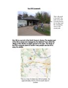
Box Hill Coursework. We went to box hill to check and see if tourism has affected the environment of box hill and how well all of these impacts are being managed.
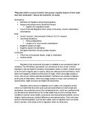
Box Hill Coursework Box Hill is a summit of the North Downs in Surrey.The western part of the hill is owned and managed by the National Trust, whilst the village of Box Hill lies on higher ground to the east. The whole of box hill is currently used for tourism many people use box hill to enjoy the wildlife. We went to box hill to check and see if tourism has affected the environment of box hill and how well all of these impacts are being managed. We also measured and calculated the number of green and wild life on the in different areas of the pathway. The impacts on box hill of leisure are likely to be getting worse and worse because many people leave rubbish lying around, although, this is not the biggest impact. One of the biggest impact is that the national trust have been building many cafes and shops for tourist which also affects the environment and wildlife of box hill, in this coursework I'm going to go through the impacts and how it can be managed. Impact of leisure use There are many various different ways in which the tourists affect box hill. One of which is the pathways, the pathways in box hill are being eroded more and more due to the high number of tourists each year. The footpath above was created and made due to the high number of tourists walking to and out of box hill, because this is the main way up, many of the insects and plants are killed. This
Kenya
Kenya is a less economiclly developed country,i no that because the death rate is 10.3/1000 which is very high,the birth rate is 37.89 which is also very bad.Kenya is quite a big country and Nairobi is the capital. most two common languages spoken in kenya are english and swahili. The official currency used in Kenya is Kenya shilling. Religion in kenya is very important, 45% protestant 33% roman catholic 0% muslim 2%

Is Africa the least developed continent?
Is Africa the least developed? Why do we hear that Africa is the least developed continent? I mean Africa contains some of the most important natural and mineral resources, so why are Africans still living in an underdeveloped continent? Naturally Africa contains a variety of many rich minerals. One of the largest minerals that Africa holds is petroleum. Petroleum is mostly found in countries like Nigeria, Libya and Equatorial Guinea. These countries are some of the richest nations in Africa, with some of the highest Gross Domestic Profits in the past few years. They are also countries, mostly the southern nations, who boast the rights of having large reserves of gold, diamonds and copper. Then they are a great number of African nations who are blessed with fertile soil, for agricultural purposes, growing some of the most important crops supplying food and exporting goods to people and other nations. Even though we see that these minerals and crops produce most of Africa's revenues, profit of this capital is found to be wasted. This money is normally given to the government, who dissipate this money on luxuries for the elite or on big projects that may have little or no return at all. We then find that colonialism could be another aspect that contributes to the economic underdevelopment in Africa. Just before decolonization, Africa obtained its highest sum of wealth.

Problems found in LEDC Shanty Towns and Solutions that are being Implented.doc
Problems found in LEDC Shanty Towns and Solutions that are being Implemented Cairo, Egypt Housing Thousands of people migrate to Cairo every week and need shelter. Some decide to live in the medieval heart of Cairo which was once one of the world's greatest trading centres. Now it is one of the greatest slums in Cairo. Every possible space is taken here - roofs pavements and rooms. There are no services and not much room. Some people decide to live in the City of Dead which is below city grounds and is where pharaohs were buried. The people live in the tombs which are much cleaner than the medieval apartments but have momentums of the dead inside. There are no services here ad the dead did not need any. New housing is being built, but not many people are buying these as they are too expensive for the poor and it is too far away from their work. These houses are being built in the desert to divert the growth of the city. A satellite city is being built - The 10th of Ramadan City - to divert growth from the city with an organised layout and many services. The satellite city offer incentives to live there - cheap land and loans, but sometimes this is too expensive for low paid workers. Work Most people are unemployed. Some people work doing simple services. Sewage There is an old system in place but this had not

What is a National Park?
What is a National Park? A national park is a large area of land that is protected by law to benefit the nation. About 10% of England and Wales has been turned into national park land. (See Map A) How The National Parks Began 00 years of yesterdays gone by many people worked in dairy factories 6 days a week, they looked forward to Sunday when they could escape to the countryside. But in the countryside, landowners were busy trying to stop visitors from entering, this made the city folk upset, big demonstrations were set up in the cities to fight for fair rights of the use of the countryside. In 1949 the government passed laws allowing the setting up of National Parks, to make sure everyone had equal access to the countryside. The first national park was the Peak District National Park in 1951. A National Park Authority manages every National Park. Who Owns National Parks? A honey pot national park, like the Peak District is one which is more popular, and has more visitors that other national parks. We went to Castleton to prove the hypothesis that there are more facilities than are needed for the local inhabitants. To do this we needed to investigate the following ideas: A: The environment in and around Castleton is going to be attractive to visitors from a wide area. We needed to find out local attractions, and features of Castleton that make it attractive and
Istanbul is a harbor city in Turkey. As the largest city in this country, the population is about 12 million and the growth rate is about 33 per cent yearly.
Istanbul Istanbul is a harbor city in Turkey. As the largest city in this country, the population is about 12 million and the growth rate is about 33 per cent yearly. Istanbul is located in North-west area in Turkey. South of the city is Marmara Sea and north of it is Black Sea. For its location, the climate is similar to oceanic climate. The temperature goes up to 30in summer and around 10 in winter. There are three categories to know more about this special city-history, economy and culture. Istanbul is a historical city. The city was controlled by many dynasties because of its special location-west part in Europe and east part in Asia, such as Byzantine, Greek and Rome. After Rome fell apart, Istanbul changed into a city which was controlled by Turkey till now. The history of Istanbul is far more than mentioned and this is one of the reasons why attract million tourists every year. Istanbul is full of mysterious. Istanbul developed a lot in recent decades; it became the center of business and industry city. It is the largest harbor in Turkey. For its location, Istanbul lacks of materials. The import worth is more than its export worth up to 69.8billion dollars. As a major shipping port, there are a great number of ships come in and out of the harbor. The major manufactures are cotton, olive oil, tobacco, silk, gold and other things. Tourists can buy these souvenirs in

To compare the main shopping districts of Chalfont St Giles and Rickmansworth.
Aim To compare the main shopping districts of Chalfont St Giles and Rickmansworth. Introduction I chose to study the village of Chalfont St Giles and the nearby town of Rickmansworth, because I live in Chalfont St Giles, and Rickmansworth is very near to me and I could get to and from there whenever necessary. Also I thought that these two locations would give me a wide variety when it came to studying my results. Chalfont St Giles is a small village in Buckinghamshire, near the conurbation of London in the South - East England. It is easily accessibility with Chalfont and Latimer train station a five-minute drive away, in Little Chalfont and buses going to and from some of the nearby shopping centres. Rickmansworth, only 15 miles away from Chalfont St Giles is in Hertfordshire. It is more accessible than Chalfont St Giles with regular bus routes and its own train station near to the centre. To compare the two places there were some factors, which I thought would be useful to investigate, these are shown below. I decided these would be helpful because I wanted to study people's opinions as well as my opinion. Also the amount of people visiting the area by foot or passing through by car. These are all useful comparisons for me to make. How Is the Land Used In Chalfont St Giles and Rickmansworth? The land use is how the town or village uses the space to build services