Methodology for our research into the environmental quality of the 2 residential areas.
Methodology Before our trip to Knutsford we planned to split into 7 groups of around 4 so that the data we collected could be calculated into a more accurate average value for us back in class to translate into graphs/charts. The fact that more people were visiting each location means that there was a average that could be calculated this means that the end result we had was closer to the true value of the data so our data would also be more accurate. The Longridge and Legh Road areas were split into 10 sites, these sites were selected so that a more widely spread area of Legh Road and Longridge can be investigated. If only 1 site from each area was investigated then the results would not be reliable because there is not a wide enough range of sites to properly investigate the environmental quality of the entire area. In our investigation on the environmental quality of the 2 residential areas we had to carry out each test equally and fairly for example for the ? litter count - 10 meters was walked along a curb side and the litter below such as chewing gum, cigarette ends and crisp wrappers were counted twice to make sure the figure was correct. An example of a result is 17 a high result, counted at longridge is 26 and a low result found in Legh Road is 0. This test is carried out to help determine the environmental quality of the area. For example because a high result

Belize - geography, development and conservation.
Belize Today in development weekly, we talk about a country which has exceeded their development in just 12,000. I am of course talking about the beautiful Belize. I was sent to Belize to investigate this country unbeknown to most and research on its coral reefs. Before we get on to the issue of the coral reefs, I though it best for you to know a little about Belize. Where is Belize? Belize is located above the equator; it is in the northern hemisphere. It sits next to the Caribbean Sea which is part of the Atlantic Ocean. Belize resides in the continent Central America, by the north of Belize is Mexico and in the south Guatemala. What's Belize like? Sectors of the economy are divided into three: Primary: The primary sector of the economy involves changing natural resources into primary products. Most products from this sector are considered raw materials for other industries. Major businesses in this sector include agriculture, agribusiness, fishing, forestry and all mining and quarrying industries. Secondary: The secondary sector of the economy includes those economic sectors that create a finished, usable product: manufacturing and construction And finally Tertiary: The tertiary sector of the economy (also known as the service sector or the service industry) is an industry that provide goods or services to consumers using raw materials from primary industry and
Revision notes on International Trade.
World Trade Primary products = Are the raw materials that are naturally present in or on the Earth before processing. E.g. as oil, wood, gold and many other things. Primary industry = Take the primary products and process them so that they are able to be used and made into something. For example, coffee making in both Brazil is a form of primary industry. Secondary products = Are products that are made from Primary products such as wood into tables and gold into jewellery. Secondary Industry = They take the raw materials produced by the primary sector and process them into manufactured goods and products. Tertiary Products = Products that are made and can't be refined any more. Tertiary industry = They sell the products that are made by the secondary industry and so that other people can use them. Imports and Exports = Countries can improve standard of living by selling more goods abroad (Exports) By this they buy goods from other countries (Imports) The difference between the value of imports and exports is called 'balance of trade' Invisible Trade = Countries such as USA make loads of money out of other countries that doesn't appear on their world trade balance. For example Ford is owned by USA but it is made in another country, Spain and they sell it. It is made by Spanish people, on Spanish land and bought by Spanish people. However all the profit goes to
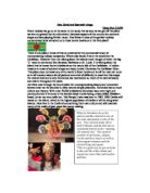
Sun, Sand and Souvenir shops
Sun, Sand and Souvenir shops Vicky Port 11MW Every holiday we go on is the same in the sense that as soon as we get off the plane we are not greeted by the cultural and historical aspects of the country but souvenir shops and bars playing British music. Has Britain's idea of the perfect holiday contaminated what attracted us to these exotic locations in the first place? There is one place I know of that is untainted by the commercial touch of moneymaking holiday companies. Where else would it be in the world but the Caribbean. However I am not talking about the islands most thought of when the big 'C' word is mentioned like Jamaica, Barbados or St. Lucia. I'm talking about the island that is known by its inhabitants as the nature isle of the Caribbean. A hidden treasure in a sea of souvenir shops and tacky hotels. Dominica the Caribbean Eden. This place does not boast any of the world's finest hotels and is off the main air route so in all honesty takes a bit of patience and a bit of difficulty to reach but this keeps the visitors low and is why Dominica has maintained so much of its natural beauty and charm throughout the years. As I first rode through the countryside the uncompromising beauty and untouched forests drew me the window to view natures simple pleasures. Dominica has so much culture and history. With only 70,000 inhabitants Dominica has a very tight knit
Travel Writing - Knowle.
Travel Writing Knowle, yes Knowle, not Knowle-West. Some people can make that mistake and it drives you crazy. For those who do not know the difference, Knowle is a quiet place where nothing much goes on, where as Knowle-West is a place where a lot of crime takes place and really it is the kind of place you would not like to live. Now that you, Mr Smith live in Knowle you are looked upon by some people as common. Really it's true, but Knowle is not all doom and gloom. I've lived there for almost four years, but there are very few hot spots to amuse yourself. There is Broadwalk shopping centre, some big name stores, like 'Iceland', Somerfield and 'Bon Marché' all crammed into one small area. Oh, and don't forget to pop into Riva Bingo while you are there. Broadwalk is like an oven, it was built before air conditioning became compulsory and its not been installed since, so you'll often find a crowd standing in the frozen food section of Somerfield, who seem to employ some very strange people like the woman who flicks through every page, then give you a strange look before you can buy a magazine. There is a large park - Redcatch Park, which has been successfully modernised, in the last few years. When I first moved to Knowle, Redcatch Park was falling apart. The play area had been destroyed and the basketball and tennis courts were in ruins. However, someone came along,

Building height prediction.
Building Heights Buildings are key features in any town or city, and Stafford is no exception. Buildings come in a variety of heights and widths. Stafford also has a vast selection of multi-aged buildings, with buildings ranging from the Victorian times to new more modern buildings. The age of the building will also affect its height, because although land prices didn't change that much nearly all-Victorian architecture consisted of very similar heights. Each building has been specially built with its location in mind, as buildings now built closer to the CBD has a higher land value while further away has a lower land rent value. In order to investigate Stafford's building heights we were split up into pairs so as to analyse each building individually. The investigation into Stafford's building heights gave me the chance to explore the following hypothesis: .) The buildings will become taller as one gets closer to the C.B.D. 2.) The buildings within the same vicinity will be of approximately similar heights. Building height Prediction This simple diagram shows that the closer to the C.B.D. you get the greater number of storeys the buildings have. This graph is only a generalisation of most towns and cities and does not work for them all. It follows the principal that because buildings closer to the C.B.D. have a higher rent price per metre squared building
Investigate the shopping centres of the Kingston Area and their patterns of use.
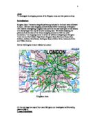
Aim: To investigate the shopping centres of the Kingston Area and their patterns of use. Introduction Kingston Upon Thames is a large Royal borough situated in the South west of Greater London. There are many shopping centres situated within the borough of Kingston that I will be investigating. Kingston town centre is the main focal point in this area as it is clearly larger then any of the other outlying town. We will be analysing the patterns of use for each of the various shopping centres and will then draw conclusions. The shopping centres in which we will be investigating are Kingston Town Centre, New Malden High Street, Kingston Road, Richmond Road, Ham, Surbiton, Surbiton Park Parade, Burlington Road, Chiltern Drive, Alexandra Drive and Villiers Avenue. Here is the Kingston Area in relation to London: On the next page is a map of the Area of Kingston our investigation will be taking place in (Fig.1). Chosen Hypotheses: ) The Larger the shopping area: - the larger the sphere of influence - the greater the average travel time - the more services present I have chosen this hypotheses because it is obvious that the larger shopping centres will have more shops and services, thus they attract more people, causing the sphere of influence to increase, which in turn causes the average travel time to the shopping centre to increase. 2) People will visit different
Gaborone ,the capital of Botswana, was created as the time of independence approached.
Gaborone, the capital of Botswana, was created as the time of independence approached. The city was built to satisfy two fundamental needs, which are the effective administration of Botswana and the promotion of a modern economy. The cities major employer is construction and majority of Gaborone's workers are employed in activities that provide commercial and government services. Gaborone is a small city that is predominant in the rural region. The city lies at latitude 29°09' S and longitude 27°20' E. It is located on a vast plain at 980m above sea level with low relief and rare isolated hills. Kgale hill is a granite outcrop, which rises to 1220m above sea level. Towards the north of the city lies the Oodi Hills also granite outcrop 1170m above sea level. Towards the west lie the Gabane Hills, which rise to 1190m above sea level and are located at the head of the Segoditsane River. The Notwane river valley dissects Gaborone. This river flows southwest northeast along the eastern boundary of the city and is controlled by the Gaborone dam. The Segoditsane River flows west east through the city and forms the main tributary to the Notwane River. The Naledi stream in the southwest and the Marapoathutlwa stream are the smaller streams that form tributaries to the Notwane River. The towns that surround Gaborone are Tlokweng towards the southeast, Mogoditshane towards the
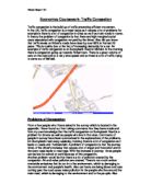
GCSE ICT Coursework Task Two – Traffic Lights
GCSE ICT Coursework Task Two - Traffic Lights Identify Local Thurrock Council Officer Dean Simpson has asked me to assist me with the setting up of a new series of temporary traffic lights in conjunction with a set of improvements to a road. The lights must control single alternate-line traffic and be able to cope with varying amounts of traffic within certain time limits. To do this I have decided to use an ICT solution because otherwise there would be a large amount of pointless and futile files describing the exact times and the working out of this would have to be done on a calculator. I have decided to use Microsoft Excel because it provides me with the ability to produce spreadsheets and be able to link them with functions such as paste link, if statements and lookup tables. I have rejected to use Character Map because it has no facilities to produce spreadsheets and I have rejected Microsoft Works' Spreadsheet because it is not as good as Excel and does not provide me with the facilities that Excel does. Analyse Mr Simpson has called me in to devise, if feasible, a system that will work out the estimated times for cars to come at certain times, the amount of cars likely to come past in a period of time and how many cars should be let through in that same period of time in order to prevent serious traffic jams. Also I will need to take into account the average length

The aim of the coursework is to prove or disprove the following hypothesis: 'There is a better quality of environment in a suburban area than in an inner city area'
The aim of the coursework is to prove or disprove the following hypothesis: 'There is a better quality of environment in a suburban area than in an inner city area' What is meant by this is that the standards of living would be higher in a suburban area compared to an inner city area. This is because the inner city is a densely populated and more crowded unlike the more pleasant spaced out suburban environment. The town which I have decided to investigate is my hometown of Billingham. The reasons that I have chosen billingham are because I live there and I know the area very well and as I live there I don't need any transport to get me there, also I know my way around billingham very well. Billingham used to be an important industrial town around the mid-twentieth century along with the rest of the Teesside area. It was renowned for its shipbuilding and steel works along with the deep docks of the river tees. However as the time past industry slowly started to decline in the area and more industries disappeared. Today ICI is still in the area at both north tees and Wilton sites, and there is only one steelworks left in the area and this is still in Redcar, but now even that is under threat, but as far as billngham is concerned it still offers quite a lot of services. It has a variety of shops such as chemists a local police station situated in the middle of the town, lots