Kobe Earthquake, Japan
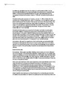
CASE STUDY - Kobe Earthquake, Japan Japan is positioned on the margin of the Eurasian Plate. Where these plates meet it is known as a subduction zone, where effectively one plate slides under the other. Along these subduction zones there are both deep and shallow earthquakes that occur due to the compressive forces against the meeting of the plates. Kobe lies in a region where the Philippine Sea Plate is thrust under the Eurasian Plate (See picture below) At Osaka Bay there is a fault called the Median Tectonic Line (MTL), and it was sudden movement along this fault that triggered the earthquake that hit Kobe. The earthquake happened early morning 5:45am JST January 17 1995, the epicentre was at Akachi. It was 7.2 on the Richter scale; this earthquake was a national catastrophe. Kobe has 1.5 million residents and is the worlds 6th largest city and port. Impacts of the Earthquake : Surface Fault Rupture: It was noticed that along the fault that there was a maximum vertical displacement of 1.2m with a right-lateral slip of 2.1m. The surface fault rupture was found to stretch over 60km from the Kobe-Nishinomiya area to the Akashi Strait. The earthquake also had a shaking intensity of X to XI on the Mercalli scale and had a maximum horizontal acceleration of 0.84g. Liquefaction: This is the result of water saturated sands found in soil being disturbed by intense

The Amazon River
Amazon The Amazon River is the second longest river in world. The headwaters begin high in the soaring Andes Mountains and stretches 6,400 km across the South American continent to the Atlantic Ocean. It discharges between 34 to 121 million liters of water per second, and depositing an average of 3 million tons of sediments near its mouth. The outpouring of water and residue is so vast that the salt content and the color of the Atlantic Ocean are altered for a distance of about 320km from the mouth of the river. Also, unlike many other rivers it¡¯s wide and straight from the headwaters to the mouth. During a new or full moon, a wave front from the ocean sweeps 650km upstream at speeds of 65km/h and this causes waves as high as 5m. Because of its vastness, annual floods, and navigability, the Amazon River is often called the Ocean River. The Amazon River is the largest and wettest tropical plain on Earth with heavy rains. Europeans were not the original keepers of this vast rainforest. The Amazonians are trapped between the old and new customs, and since they have traditions, their technology isn¡¯t as modern as the rest of the worlds¡¯. They live on the richest land with a wide variety of flora and fauna. With such great resources, including the river as transportation, almost anybody would want to seize the land and gain profits easily. The Amazonians have little
Moneyless in Madras: Millionaires in Manhattan
Moneyless in Madras: Millionaires in Manhattan Warm droplets of rainwater bombarded the tin roof of the extremely modest dwelling that had a greater resemblance to a dog's kennel than the home of two men. The house was empty as the rain chattered loudly and naggingly on the roof. The sides of the house consisted of wood which had - by the look of it -been incompetently put together. On one of the four sides of the hut there was a gap in the wood, it had been covered by an old scruffy looking cloth, this gap was man-made and signified the threshold of the dwelling. There was no flooring in the shoddy dwelling which was reluctantly called home by two impoverished men. Instead there was natural ground that was parched suggesting that the dwelling had been set up before the rainy season had hit. Looking into the box shaped shelter through one of the many splinters of wood, one could see a few logs, which must have been used for fires. In a corner there were two Hessian mats which were no doubt used by the two men to imitate beds. There was little apart from that. This rather unattractive hut was a great contrast to its picturesque surroundings. The landscape was full of flora and fauna which were clearly blossoming thanks to the much needed and overdue rains. The woodland was a lush green colour as were the surrounding hills intercepted by deep valleys. The hut was in the middle

Investigationg Eco-systems At Sand Dunes
Geography Coursework Introduction For our Geography coursework we will investigate the ecosystem of Murlough Sand Dunes in groups of two. Murlough Sand Dunes are situated at Dundrum Bay, County Down as seen in the map to the right. During the Ice Age, over 10,000 years ago, a large ice sheet moved to the North West area. The ice sheet was separated by the Mourne Mountains. The weight of this ice sheet pushed down on the earth's crush causing land and sea levels to be lowered. After the ice age, land levels began rising again when the weight of the ice sheet was reduced, and sea levels also increased due to the melting ice. At Murlough Sand Dunes the land levels rose more than sea levels and so the dunes began to gradually form. When we investigate at Murlough Sand Dunes we will be aiming to look at: * Soil Variables: differences in soil pH, percent of soil moisture and percent of soil organic content between the older and younger sand dunes * Vegetation Variables: variety of vegetation species, percent of bare ground and percent of vegetation cover between younger and older dunes * How soil variables and vegetation variables are linked (e.g. how the growth of marram grass is affected by soil acidity) From these aims we expect to find that soil pH is more acidic in the older dunes, while more alkaline in the younger dunes, percent of soil moisture and

Tropical Rainforest
Structure of vegetation in the rainforest Emergent's are the tallest trees and are usually over 50 meters tall. The sea of leaves blocking out the sun from the lower layers is called the canopy. The under canopy mainly contains bare tree trunks. The shrub layer has the densest plant growth. It contains shrubs and ferns and other plants needing less light. The forest floor is usually dark and damp. It contains a layer of rotting leaves and dead animals. Impacts on indigenous people • The replacement of forest with grassland can also have a major effect on the way of life of indigenous people. Without the forest wood, they cannot make the artifacts, tools, and buildings that are an important part of their economy • Deforestation in indigenous territories by loggers has sometimes triggered violent conflict. Logging, mining, and farming in tropical forests sometimes displace native communities. Left without land or other resources, native cultures often break up. • ropical forests are home to millions of native people who make their livings through subsistence agriculture, hunting and gathering, or through low-impact harvesting of forest products like rubber or nuts Conservation of tropical rainforest - The Korup Project • The Korup Project in South-West Cameroon is an attempt to conserve an area of pristine rainforest. The main aims of Korup Project

Debden Brook Rivers Coursework Data Collection Table
Data Collected Which hypothesis will it be used to prove or disprove? Equipment Used How was the data collected? Strengths of the data and method of collection Weaknesses of the data and method of collection Water Width The width of the river increases with distance downstream. - 3 people - Tape Measure We needed two to three people to obtain data for this measurement. One person stood on one side of the river, the second on the other side and the last person was be recording the results while the measurement was being carried out. Firstly we got one person to stand one side of the river and hold the end of the tape measure where the surface of the water touches the shore then the other person layed the tape measure over the surface of the water to the other side and took the measurement. Finally, the last person standing would record the results as soon as possible to prevent writing down wrong data. - It was primary data (data obtained firsthand by the person presenting the data) - Only required a tape measurer - Simple-to-use and easy method - Person recorded data straight away to avoid writing wrong data - Hardly any chance of human error because it was so straight forward. - We used the same tape at every site which meant it was a fair test. - The tools used did not cost a lot. - Used cheap, simple equipment (tape measure) - Tape measure was very old,

What effect does Human Activity have on Coastal Landforms
What effects does Human Activity have on Coastal Landforms Human activities add another layer of complexity to the natural processes of coastal lands and materials. These activities may have direct or indirect effects on our changing coastlines. They may effect sources of new sediment to the coast and the movement of sediment within the coastal environment. Sediment starvation caused by river and coastal management is one effect of human activities on the coast. For some coastal regions, such as the Pacific coast, a large part of their sediment is supplied by rivers. Dams built for flood control and water catchment along the rivers leading to these coasts inhibit the transport of large grained sediment, The coasts lack new material so erode and move inland. For instance damming of the tributary rivers to the Mississippi River over the past 60 years has reduced the movement of sediment. Studies in recent years have demonstrated that the amount of sediment carried by the Mississippi has been cut in half, aggravating the deterioration of Louisiana's wetlands. An important source of sediment to Louisiana's delta wetlands was periodic flooding of the Mississippi River, which deposits new material on the flood plain. Massive levees built along the river bans now contain these floods and eliminate the supply of sediment to the wetlands. As a results, the natural compaction and
Does Global Warming exist?
Does Global Warming exist? Evidence For: Evidence Against: * Methane Increasing Levels of atmospheric methane, a powerful greenhouse gas, have risen 145% in the last 100 years. Methane is derived from sources such as rice paddies, bovine flatulence, bacteria in bogs and fossil fuel production. * Peculiar Weather Recently, young people in Vietnam noticed strange white stuff covering the fields. They had never seen snow before. It is the coldest spell in the country for 20 years. * Carbon Dioxide Increasing in Atmosphere The atmospheric levels of the greenhouse gas carbon dioxide, have increased since pre-industrial times from 280 part per million (ppm) to 360 ppm, a 30% increase. Carbon dioxide concentrations in the atmosphere are the highest in 160,000 years. Carbon dioxide is a by-product of the burning of fossil fuels, such as gasoline in an automobile or coal in a power plant generating electricity. * Cooling Poles Recently, scientists found that temperatures in the Arctic have been cooling since the 1920s. Computer predictions are that, if the world is warming, the Poles should warm twice as much. * Disappearing Glaciers Ice is melting all over the planet. Glaciers are melting on six continents. If present warming trends continue, all glaciers in Glacier National Park could be gone by 2030. The park's Grinnell Glacier is already 90% gone. - Ice cores taken

Bangladesh Problems
Bangladesh Problems. Bangladesh is considered a third world country; the major crisis Bangladesh endures is poverty. Increasing at a rate of about 2.06% per year, the current population of Bangladesh is about 138 million. 35.6% of the population is below the poverty line (Coutsoukis). Steps are taken to diminish the number of citizens that are below the poverty line. For example, Bangladesh decreased its illiteracy level of females from 73.5% in 1995 (Data Profile) to 31.8% in 2003 (Coutsoukis). This means that more and more people are deciding to receive an education. The Bangladesh government and the Bangladesh Aid Group have taken seriously the idea that Bangladesh is the test case for development. In the late 1980s, it was possible to say, in the somewhat patronizing tone sometimes adopted by representatives of donor organizations, that Bangladesh had generally been a "good performer." Even in straitened times for the industrialized countries, Bangladesh remained a favored country for substantial commitments of new aid resources from a strikingly broad range of donors. Even with the greatest imaginable efficiency in planning and administration, resource-poor and overpopulated Bangladesh cannot achieve significant economic improvements on the basis of that level of assistance. In examining the economy of Bangladesh, wherever one turns the problems crowd in and threaten

Common types of coastal problems are: pollution, erosion, salt intrusion, flooding calamities, habitat degradation / loss of biodiversity.
Anne Milot Enviromental Geography Topic: Coastal Problems Common types of coastal problems are: pollution, erosion, salt intrusion, flooding calamities, habitat degradation / loss of biodiversity. Coastal erosion of rocky cliffs and sandy beaches results from the action of ocean waves and currents. This is especially severe during storms. In many parts of the world the loss of land due to coastal erosion represents a serious problem. The action of waves, however, does not extend to a great depth, and the sea tends to cut a flat platform, characteristic of marine erosion, into coastal rocks. Various measures can be taken to reduce the risk of flooding, especially in the settled parts of floodplains. One of the most effective methods of reducing damage has been to alter the size of floods themselves. By planting trees, controlling soil erosion, and preserving wetlands, people have helped to reduce the size of floods. Special channels have been constructed to divert floodwaters away from built-up areas. The construction of dams has also been a very successful means of controlling floods. Constructing dams, however, can also alter the processes that shape the floodplains farther downstream. Since most sediment carried by a river settles out in the reservoir behind a dam, the water flowing past a dam has very little sediment in it. Water poor in sediment will scour sediment