Introduction and background info
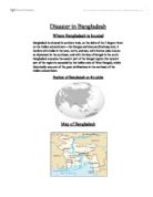
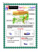
Hosting a population of around 140 million people, Bangladesh is the most densely populated agricultural country in the world. Physically, it is a small, low-lying, riverine country which is situated in South-East Asia (it is 55,599 sq miles large). It borders the Bay of Bengal, between its neighbours Burma, in the in the South-East and India, in the North-East. Its terrain is mainly flat, with hills scattered sparsely in the South-East. Bangladesh is located in the world’s largest flood plain and delta-the Gangetic Delta. This is made up by the confluence of the Ganges (Padma), Brahmaputra (Jamuna), and Meghna Rivers and their tributaries which empty into the Bay of Bengal for irrigation purposes as well. In addition, 90% of landmass less than 10 m above sea level, which makes the country very prone to flooding- in fact it’s one of the most flood prone country’s in the World. The climate of the country doesn’t help Bangladesh’s situation, infact it plays a major part in hindering it. The climate’s typically tropical, hot, and humid in summer (March-June), cool, rainy monsoon (June-October), and cool and dry in the winter (October-March). Bangladesh has many regular occurrences of cyclones, storm surges, and therefore floods, due to the climatic conditions. Aside its flood prone geographical position, the other natural, environmental factors which cause the country’s devastating floods include the build up of eroded soil to river banks, which is a major factor in creating a negative funnel effect. Erosion leads to the rise of river beds, reducing the capacity of water that the rivers can contain, whilst increasing the amount of spillages created, this in turn creates a negative multiplier effect for residents. Human factors also make the effects of flooding worse for the country, such as sinking water wells-due to influxes in population, deforestation in Nepal which are used as fuel-to feed cater for Nepal’s growing population-which increases the amount of run-off from waters coming to the country, and decreasing the amount absorbed by anchoring tree roots, from surface run-off from the Himalaya mountains (the largest range in the world) from precipitation stores. Diversion of the Ganges Rivers due to irrigation purposes creates a wider spread out of water. Long term affects also include the devastating effects of global warming, which can also be seen around the globe too. Floods are so severe in the country that have made World records; They include the Bangladesh Flood of 1998-the worst flood of the 20th century, lasting over 2 months, whilst the 1988 floods caused thousands of fatalities, not an unusual sight in Bangladesh. They effectively damage the county’s economy, appearance, livelihoods, homes, and lives. Along with floods droughts also occur in the country, so flooding can be a blessing in the country, which heavily depends on agriculture as part of maintaining its economy-it’s one of Bangladesh’s biggest industries (along side the textiles trade), by bringing much needed rich, alluvium silt, which provides useful nutrients to crops-such as staple foods of rice and wheat-which the country doesn’t just export, but uses for themselves too. This is vital, as Bangladesh is amongst one of the world’s poorest countries. It is an L.E.D.C, where the GDP per Capita is about $440* (2006), while a MEDCs which would be more than $2000. Due to the fact that Bangladesh is so poor, naturally, it has a lot of trouble recovering from the devastation that floods bring, and so they desperately depend on foreign/ international aid to help them to recover. This is where the USA controversially got involved. They have first hand experience from the results of flood damage from the Mississippi River (it runs across the length of the country), and while they have now more or less brought under control their floods, they now want to sell on their state of the art technology, and have Bangladesh on their radar. Below is a list of the strategies that they are being offered, and what they involve. I have written the advantages of using each technique by their side, and further below I have evaluated the techniques efficiency. They are all ‘hard’ engineering options, which mean that they are major projects, which in turn have a larger impact on the river and surrounding landscape.