National Parks.
National Park National parks are renowned for there great natural beauty and spectacular scenery. National parks contain some of the most diverse and magnificent upland scenery in England and Wales. British National parks are administrated by a National Park Authority, whose job is to keep the parks a special place for everyone that decides to visit it. This is achieved by; * Conserving and enhancing the natural beauty, wildlife and cultural heritage * Promoting opportunities for the understanding and enjoyment of its special qualities All National Parks try to aim for Sustainable Development; this means they must be conserved in order to prevent the countryside being destroyed by people or industrial activity. In trying to keep all of these aims the National Park Authority also has to consider in the future, any factors which may affect any residents in the area, making sure that they are socially and economically secure. The term 'National park' is rather misleading in the sense that the state does not own the vast majority of the UK's National Parks. The UK's National Parks are protected landscapes that consist of many plots of land which are owned by different individuals, including private house owners, farmers and organisations such as water boards and the National Trust. They are National Parks in the sense that everybody is encouraged to see the spectacular

Marine Pollution
Marine Pollution I am writing to convince the UK Government that it is time to take action to protect the seas around us. The harm being done to our oceans is damaging in many ways - not least because with increasing speed, we are severely depleting the world's stock of fish. For four centuries the seas have been considered on inexhaustible resource from which people could take as much as they wanted. Now we have to face up to the fact that our oceans are not limitless - more and more people competing for less and less fish are which is making the existing crisis worse. Many marine ecosystems are at the point of collapse and will be destroyed unless we act quickly to protect them from the most serious threats. Pollution from ships Ships can pollute waterways and oceans in many ways. Oil spills can have devastating effects. While being toxic to marine life, polycyclic aromatic hydrocarbons (PAHs), the components in crude oil, are very difficult to clean up, and last for years in the sediment and marine environment. Discharge of cargo residues from bulk carriers can pollute ports, waterways and oceans. In many instances vessels intentionally discharge illegal wastes despite foreign and domestic regulation prohibiting such actions. Ships create noise pollution that disturbs natural wildlife, and water from ballast tanks can spread harmful algae and other invasive

Why did so many people die in the Kobe Earthquake?
Why did so many people die in the Kobe Earthquake? Kobe is a major city in central Japan, its population is 1,528,948. It is situated on a minor fault, the Najima fault line. It lies above a destructive plate margin, hence why Japan has so many volcanoes. At 5.46pm, 17th January 1995 an earthquake measuring 7.2 on the Richter scale and lasting for 30 seconds, struck Kobe. This colossus earthquake was caused by "The Philippines plate" and the "Pacific plate", (Oceanic Crust) getting forced downwards when pressure was applied to it by the Eurasian plate (continental crust). The seismic waves caused by the plates rippled through the earth's surface. As well as causing earthquakes these events can cause Volcanoes. The magma rises out of the earth and out of the cracks which have been formed. Although this earthquake may seem big, it is still relatively small compared to the ones that the American people have to endure in San Francisco and California. These one's reach 8-9 on the Richter scale! They are located on the "Ring of fire", which also lies above a destructive plate margin. As you may or may not know, Japan is basically an island made up of volcanoes sticking out of the ground. This means there is very little flat land other than at the base of the volcanoes. Due to this, it is very crowded and congested. Believe it or not the population Of Japan is 124
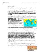
Letter about a volcanos DRAFT
Dear Senor Jose Cruz You asked me to find out about your volcano poco-poco. I am going to tell you where volcanoes occur and why they erupt in these places, the dangers of them and the dangers of them happening in Mount Isle, what happens when they erupt and the process of getting to the eruption, why volcanoes erupt in the Caribbean region, other examples of eruptions in the Caribbean region, how scientists can monitor and predict volcanic eruptions, why there has been little research on Poco-poco in the past and how the citizens of Iguana Cay could prepare for a possible eruptions and what they should do in the event of an eruption. Volcanic eruptions occur only in certain places in the world and do not occur randomly. That's because the Earth's outermost shell is broken into a series of slabs known as tectonic plates. These plates are rigid, but they float on the hotter, softer layer in the Earth's mantle. There are 16 major plates as you can see in the map. As the plates move about, they spread apart, collide, or slide past each other. Volcanoes occur when this movement occurs. As you can see the Caribbean is next to a plate boundary. This explains why eruptions happen in this area. There have been several eruptions in the Caribbean region such as Montserrat in 1995. St. Kitts has erupted 27 times and St. Eustatius last erupted 1,600 years before present. Future volcanic
Earthquakes in MEDC's and LEDC's
A well-known principle states that the impact of earthquakes in LEDC's or Less Economically Developed Countries is generally more severe when compared with MEDC's or More Economically Developed Countries. This shall be illustrated by comparing the Kobe Earthquake in Japan of 1995 with the Kashmir Earthquake of 2005. The Kobe Earthquake occurred on Tuesday, January 17, 1995, at 05:46 JST in the southern part of Hyogo Prefecture, Japan. It measured 7.2 on the Richter scale and lasted for 20 seconds. The duration of the tremors was around 20 seconds long. The focus of the earthquake was located 16km below the epicentre, on the northern edge of the Awaji Island, approximately 20km from Kobe. The proximity to the city was a major factor of its widespread devastation. The ground moved 18cm horizontally and 12 cm vertically. The Kashmir Earthquake was caused by the Eurasian and Indian tectonic plate boundaries colliding. Its epicentre was located in Azad Kashmir near the city of Muzaffarabad. It occurred at 08:52:37 Pakistan Standard Time (03:52:37 UTC) on 8 October 2005. According to the authorities, 79000 people died. A major factor in the severity of the earthquake was the poor construction - a salient feature of LEDC's. The Indian Plate which was moving 40 mm a year north collided with the Eurasian plate and was forced beneath it. It measured 7.6 on the Richter Scale. As is
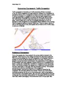
Economics Coursework- Traffic Congestion
Economics Coursework- Traffic Congestion Traffic congestion is the build up of traffic preventing efficient movement. In the UK, traffic congestion is a major issue as it causes a lot of problems for example is there is a lot of congestion in cities as well as main roads in towns. In theory the problem of congestion is that there are high marginal social costs associated with congestion not paid by the driver. Also did you know that traffic levels on Britain's roads have risen by over 80% in the last 20 years. This is mainly due to the fact of increasing demands for a car. An example of traffic congestion is on Sunnybank Road in Mirfield. In the morning there is congestion going up towards Roberttown. There is a great volume of cars on the road and at a very slow speed and so there is a lot of traffic trying to come out of Mirfield. Problems of Congestion From a few people who I have asked in the survey which is located in the appendix. I have found out from taking comments that they have made and from my own knowledge that the traffic congestion on Sunnybank Road is a problem for drivers as well as people who live in that area. Comments of people in survey have been summarised in the explanations of the problems. On Sunnybank road every weekday morning there is a lot of congestion as it leads to Leeds and Huddersfield. A problem of congestion is that the journey times

Olympic Sites 2012 - how will the globally known Olympic games have an impact on East London and why not hold them in any other area of London?
Geography newspaper The 2012 Olympics are going to be held in London over Paris because of promises of greener games and a huge improvement on the people and land of East London. But how will the globally known Olympic games have an impact on East London and why not hold them in any other area of London? Although many events will be held across London (table of events and corresponding locations in London below) the main Olympic stadium will be holding all the athletic events and the opening and closing ceremony. This stadium will be built in Lower Lea Valley in East London. It is being built here because the government believes that it will rejuvenate this run-down and derelict area of London by bringing a worldwide known event to this area, which in turn will bring tourism and new public services. Event location of event Road cycling Reagent's Park Triathlon Hyde Park Beach Volleyball Horse guard's parade Gymnastics O2 Arena (Millwall) Athletics Olympic Stadium Swimming/diving Aquadome Horse Events Greenwich Archery Camden Town Lower Lea Valley is the area around the river Lea which has been contaminated by old industry and a landfill site which have polluted the surrounding area and river with arsenic, lead, petrol, oil, tar and litter. The jobs available in this section of London would have been limited to the nearby chemical plant, soap factory;

Castleton Project.
CASTLETON PROJECT Where is Castleton? Castleton is located in the Peak District National Park; it lies towards the north of the National Park. It is 10 miles from Buxton and 16 miles from Sheffield and 27 miles from Stockport. Around half of the population of England live within 60 miles of the Peak Park. Castleton has many human and natural attractions. These include: * Caverns * Pevril Castle * Mam Tor * Attractive Scenery What problems do tourists cause around Castleton? Castleton is a one of the Peak Districts most popular places. I think people like it because it has beautiful scenery and lots of different places to go to like the caverns, there are four caverns in Castleton: - Speedwell Cavern, Blue John Cavern, Treak Cliff Cavern and Peak cavern. Castleton receives over 2 million visitors every year. This large number of tourist causes many problems in and around Castleton. These problems include - Litter is a big problem in Castleton as the bins are overflowing and some people just don't use them. Traffic Congestion is a problem in the village to both locals and visitors. There is a large car park, with space for coaches, and public toilets. On very busy days people just park wherever they want even in front of peoples gates. There is footpath erosion in Castleton resulting from overuse. This is particularly the case around popular natural attractions

Sea Defence. Which is better: hard or soft engineering?
Which is better: hard or soft engineering? Hard engineering options tend to be expensive, short-term options. They may also have a high impact on the landscape or environment and be unsustainable. Hard engineering is the controlled disruption of natural processes by using man-made structures. An example of hard engineering is a sea wall, these walls are built on the edge of a coastline and made to protect the base of cliffs and also to limit the amount of coastal erosion on a cliff-face were land is being absorbed by the sea. These walls could also prevent coastal flooding. This type of hard engineering is good as it has many aspects and is effective. Disadvantages of creating a sea wall are that it is very expensive to build; the curves in the sea wall reflect the wave's energy back to into the sea, therefore the waves remain powerful. Another disadvantage is that the walls erode after time and the cost of maintenance is high. Another example of hard engineering is groyne, a groyne is a wooden barrier built at a right angle to the beach. Groynes are built to prevent the movement of beach material along the coast by long shore drift. This allows the build-up of a beach; beaches are a natural defence against erosion and also an attraction for tourists. Disadvantages of building a groyne are that it can be seen as unattractive and is also costly to build and maintain. A

Mount Sakurajima volcano report.
By Joseph Hemingway Location: Kyushu, Japan Height: 3,665ft Type: Stratovolcano - also called a composite volcano, is a tall, conical volcano composed of many layers of hardened lava, tephra, and volcanic ash. Last Eruption: 2007 914 * The 1914 eruption has been the most powerful in the Japanese twentieth century. * During the eruption lava flows filled in the narrow strait between the island and the mainland, converting it into a peninsula. * Before 1914, the volcano had been dormant for over a century. * The eruption began on 11 January 1914. * Almost all residents had left the island in the previous days, in response to several large earthquakes which warned them that an eruption was imminent. * Initially, the eruption had been very explosive, generating eruption columns and pyroclastic flows, but after a very large earthquake on 13 January 1914 which killed 35 people, it became effusive, generating a large lava flow. * Lava flows are rare in Japan-the high but the lava flows at Sakurajima continued for months. * The island grew, engulfing several smaller islands nearby, and eventually becoming connected to the mainland by a narrow isthmus. Recent Activity * The volcano resumed activity in 1955, and has been erupting almost constantly ever since. * Thousands of small explosions occur each year, throwing ash to heights of up to a few kilometers above the