Geography Courswork
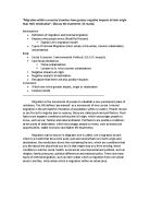
Geography Coursework This is the first part of my geography coursework; this coursework will be based upon the Ilford town centre and also an area which I choose. In this coursework I will describe the changes which have occurred in Ilford over the last decade, these changes include: * How the Ilford car park has changed into a multiplex cineworld * How there has been a diverse change in the local community within Ilford * How the shops have affected the local community and their own customers However to illustrate these changes I will be interviewing families in the local area which have been affected by the change, and also local shop areas. I will also be using a questionnaire to find out the views and thoughts of the local community and people who visit Ilford regularly. I will be questioning them about how the change in Ilford has affected them. I will also be comparing Ilford and my local area as it is in the vicinity of Ilford, this will show the differences and similarities between the two local areas. The main aspects which I will be comparing between the two areas are: * Land Use * Roads * Bus Service * Trains * Shops Over the last two decades Ilford has been through rapid changes, including the structure, commercial properties, population and one of the most noticeable changes is the transformation of the Ilford car park to a multiplex cinema. Above is a
Analysis of The Maer at exmouth, coursework
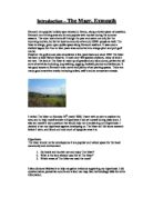
Introduction - The Maer, Exmouth Exmouth is a popular holiday spot situated in Devon, along a lovely piece of coastline. Exmouth is a thriving area and is very popular with tourists during the summer seasons. The town host events all through the year and caters not only for the incoming tourists, but for its local community of around 35000 people as well. The Maer is a large, green open public space along Exmouth seafront. It was once a shallow lagoon but then in later years was converted into a large pitch and putt golf course. However the golf course was demolished a few years back and since 1992 The Maer has been a local Nature Reserve. It hosts over 400 species of plants, many of which are rare. The land at The Maer is made up of grassland and sand-dunes, perfect for all sorts of activities including; dog walking, jogging, football, picnics and barbeques. It has good access to Exmouth town centre and plenty of car parking spaces. There are many good amenities nearby including toilets, café's and an amusement arcade. I visited The Maer on Monday 16th march 2009. I went with an aim to explore the area, and to help myself answer a Hypothesis I had set myself during class work. I also set myself 3 key questions that would help me in answering my Hypothesis. I decided to set my hypothesis against developing on The Maer as I did some research before I went, and found out how
Bangladesh Brochure
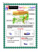
Location of Bangladesh Bangladesh is situated either side of the tropic of cancer. India shares its border with Bangladesh. The three main river flows through Bangladesh are the meghna, the Brahmaputra and the Ganges. The north of Bangladesh is the Himalaya Mountains, the highest mountains in the world. To the south is the Bay of Bengal. The Land & People Landforms: Flood Plains Population: 126 Million Delta Population Density: 800 per square kilometer The Land is Under 15 meters above sea levels 230 of rivers in Bangladesh What are Tropical Cyclones? Tropical storm, typhoon or hurricane is a type of low pressure system which generally forms in the tropics. While they can be highly destructive, tropical cyclones are an important part of the atmosphere circulation system which moves heat from the equatorial region toward the higher latitude. Keyword: Latitude: The distance of a place north or south from the equator (Places that are near to the equator or much warmer than places that are near the north and south poles.) How Are Tropical Cyclones Formed . Formative - clouds start forming over the ocean between 5 and 15 degrees latitude from the equator. 2. Immature - if the conditions are favorable, clouds

GCSE Geography
Introduction Druridge bay is located 47miles from Berwick, 10miles from Morpeth, 23.6miles from Newcastle. I have been asked to answer three questions about the sand dunes at druridge bay and the management of the park. Druridge Bay Country Park includes three miles of beautiful beach and sand dunes, as well as a 100 acre lake surrounded by woods and meadows. There is a wide variety in the landscape. The park concedes of beach land woodlands and a lake. The bay its self is about 5 miles long and the golden sands are preserved in areas that are near small villages. Whereas in certain areas the beach is left for man to trample all over it and destroy its natural beauty. This beach in the north-east is a gem of the east coast with its rolling dunes slowly decaying due to human activity. In this piece of work I will be answering three key questions that concern the welfare of the beach. Key Question one "how do the dunes at druridge bay compare with a model sand dune" Introduction In this key question I am going to compare a model sand dune with the dunes a Druridge bay. I will also be comparing the vegetation found on the dunes at Druridge bay and what I should be expected to find on a model sand dune. The model sand dune consists of an embryo dune followed by a yellow dune followed by a semi-fixed dune followed by a fixed dune. That is what the dunes at druridge bay should

Travel and Tourism Worldwide Travel Destinations - Paris
AVCE Travel and Tourism Worldwide Travel Destinations Paris Task 1: General information: France is the second largest country in Europe and it fall into the northern hemisphere. In the northwest there is, the Brittany Peninsula, Normandy, which has fertile uplands, the Loire Valley and the Seine basin. In the south, the ground rises to the Massif Central; a region of high plateaux and in the east is the Rhone Valley. On the eastern boarders of France are the Jura Mountains, the Vosges and the Western Alps, which fall away on their northern slopes to Alsace-Lorraine. France has a population of 59 million people, who are scattered throughout the country, although Paris has 2.2 million people living in its city. The population is made up of: * French- 92% * North African- 3% * German- 2% * Breton- 1% * Other- 2% (Source: Lonely Planet guide for France) Government: The full name of France is the French Republic. The government type is called Republic and the president is Jacques Chirac. He was elected in 1995 while the prime- minister, Lionel Jospin, was appointed in 1997. The government has twenty-two administrative divisions, which consist of: * Alsace * Aquitaine * Auvergne * Basse-Normandie * Bourgogne * Bretagne * Centre * Champagne-Ardenne * Corse * Franche-Comte * Haute-Normandie * Île-de-France (Paris falls into this administrative division) *

Maneging coral reefs
Introduction Coral reefs are unique ecosystems of plants, animals, and their associated geological framework. The ocean equivalent of rainforests, they are home to 25% of all marine species, yet it is estimated that many of the world's reefs will be destroyed or significantly damaged in the next 20 years because of the human and the physical damage put on to them. They grow in tropical seas in the photic zone, where there is mild wave action, not so strong to tear the reef apart yet strong enough to stir the water and deliver sufficient food and oxygen. Coral reefs also need nutrient-poor, clear, warm, shallow water to grow. Human Threats to the Coral reefs Tourist There are a number of different human threats applied to the coral reefs, most of it which is caused by tourists. These activities are; * Snorkelling- Inexperienced snorkellers can trample corals with their flippers. The can also damage the corals by getting to close and resting on the reefs. * Boat trips- Cruses taking visitors out to the reefs are often careless when the drop their anchor. The anchor will crush the delicate corals with their weight. The water movements made by the boats travelling too fast will damage the corals the force applied to the corals underwater. When the boats get to close to the reefs, the hull tends to scrape past the corals, damaging them. * Boat hire- Tourist don't tend to

Between Prawle point and Start Bay
How have human activities shaped the landscape between Prawle Point and Start Bay? On day two, we analysed the human home settlements found in the villages of Hallsands, Beesands and Torcross. The whole aim of doing this was to find how these man made homes and settlements have affected the land at each village, and how other human activities have affected these settlements vulnerability to coastal damage, as how the natural coastline has developed due to this. We also looked at how these settlements have used man made sea defences t help protect them from coastal attacks. Route Firstly, here is the route we took along the coast from Start point (red) to Torcross (green), passing both Beesands and Hallsands along the way. Hallsands - Description When we visited Hallsands we noticed that it was had very small population, with little human settlements which were all near each other. Hallsands also had many narrow rough roads throughout the village and was ear the shore. Hallsands - History Between the years 1894-1903 the shingle beach close to Hallsands was lowered by 1.4m, due to the continuous taking of the shingle to build the dockyards at Plymouth. This made the village of Hallsands extremely vulnerable and open to floods from the waves of the sea. In 1917 a storm with 10m waves destroyed the now unprotected village of Hallsands which was no longer protected by the

Global warming is a growing problem in the world but the sad thing is the people who are least responsible for Global warming are the ones that will suffer most.
Global warming is a growing problem in the world but the sad thing is the people who are least responsible for Global warming are the ones that will suffer most. Many things are going to be affected by global warming such as the weather. We will start to see major increases in freak weather such as hurricanes and tsunamis. With the world expected to increase in temperature by at least 1 degree Fahrenheit. This may not sound like much but it will have terrible consequences for our Earth including what I mentioned above. What are the causes of Global warming? Carbon Dioxide Carbon Dioxide the largest contributor to Global Warming. Carbon Dioxide is caused mainly through emissions through Electricity and Fuel. Carbon Emissions are also strong from Power Plants incidentally 40% of the emissions from the USA are from Power Plants. Other Causes: Methane Increasing Water Vapour Nitrous Oxide City Gridlocks Deforestation Deforestation is a major problem in the world, the Amazon has nearly halved in size since the start of the deforestation work there began. Trees are a major part in our oxygen supply they take in our Carbon Dioxide which we breath out and they breath out oxygen for us to breath. This is a continual cycle but with the decrease of trees where will the excess of Carbon dioxide be going? What will be the Consequences for the UK. Although Newcastle itself

GIS-Harrow
For my report I've chosen 4 GIS maps from the Harrow council's official website (to make the results more reliable) that show the differentiation between the standards of living across the London borough of Harrow. The GIS maps that I chose (and copied as evidence) include: population density, life expectancy, street crime, and income levels; I have analysed them and described what the variations in each map are and what they show us. To conclude my report I have compared the variations in all the maps, and described what they show us. This map shows the main wards in the borough of Harrow. Pop. Density This map (see above) shows the population density levels in wards across Harrow. The map shows us that there is a mix of both high and low population density levels across the borough. The north east and west of the borough is the most sparsest, as it's got the lowest amount of people per hectare- 5-less than 40 people and 40-less than 55 High per hectare. Population density levels are more concentrated in the centre of the borough, where wards like Wealdstone, headstone north, Kenton west, and Marlborough are located, with equally high density levels spreading towards the south of the borough-towards the south east, where high pop. density levels are also highly concentrated, Kenton east is situated there. The south west of the borough has more of a mix of pop.
Population Density and CBD
Name an area of the UK which you have studied describe and explain why it has a high population density. Greater London, in the South East of England is very densely populated. The area is situated around central London and the River Thames. The main economic reasons that London is densely populated are: It is the most accessible part of the UK with train links to all over the UK and Paris, France. Six Major motorways start from London and lead out all over the country, this makes it more popular for people who are commuting to and from London everyday and tourists from all over. The largest and the UK's wealthiest markets are situated in London, as well as businesses and other firms. This is because London is the capital city of England and has all the major government buildings as well. London also has a large variety of work, compared to other remote or less populated parts of the country, London has many more job opportunities, low and high paid. This attracts people to Greater London for residential purposes. Other reasons are, that London has an absence of harsh climates, which makes it more popular to live, other places like Scotland are higher up and nearer to the colder parts. This makes London more popular with tourists as well as residents. London also is the centre of all communications throughout the UK because it is the capital city. This brings more people to