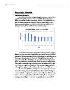
Geography- Darfur crisis
DARFUR by Bob anderson Explain the origins of the crisis. There is no pin pointing exactly when the crisis in Darfur commenced, but it has escalated into a catastrophic disaster. To fully understand the origin of the problems in Darfur you need to understand the history of Sudan. Sudan was a British colony until 1956, its independence was won at the cost of a civil war. The president Omar Hassan al Bashir and his party, called the National Congress Party, gained power in a military coup in 1989. The government is situated in the capital Khartoum. Sudan is 52% non-Arab or Black African, 39% Arab, and 6% other. Immense inequalities exist among the different regions with most of the wealth and power concentrated in Khartoum, Khartoum has witnessed a recent growth in wealth due to the commodities prices (most notably oil), which have created a booming economy primarily in and around the capital city. The governments policies of neglect, marginalization, economic exploitation, and religious oppression have created enormous tensions between the Government of Sudan and other regions of the country. This inequality between ethnic groups has caused countless rebellions, and brutal retaliations by the government. The present crisis in Darfur initiated when hostilities flared between Arab Nomadic herdsmen and non-Arab African farmers in an area of Western Sudan. These conflicts

Rice Production Case study
Sungai Petani is the second largest city, in the State of Kedah, it is called the rice bowl of Malaysia, as it produces the majority of rice for the country of Malaysia. 31.05% of all the rice produced in Malaysia could be traced back to Kedah, making Sungai Petani a major contributor to Malaysia's rice production. Factors contributing to this cities' success in growing rice is the fertile soil in the area because of the Sungai river running through Sungai Petani, continued annually Rice is a complicated food source, but because of it's complexity people are able to maximize yields year after year. In order to grow rice, the area being grown in, must be flooded, so that the rice plant's roots can get nutrient directly from the water. Flooded areas are called paddies, not only can one grow rice fish can also be grown without effecting crop yields. This must be done in advance to accept sprouted seed from the seedbeds. In LEDC's this is all done by hand and is a back breaking job, done mostly by females, and if needed males would help out. In order to flooded fields and create paddies, one must construct "Bunds" and dams, to control the water for the paddies to ensure that it stays flooded, in Sungai Petani they rely on the Petani river to provide their fields with water. When farmers grow rice year after year the nitrogen and nutrients in the soils becomes depleted
Sao Paolo
Geography PROJECT Population and Demographics Sao Paulo Sanym Paritova . Growth rate tables over time Year Population (million) Growth rate (annual %) Urban area (km²) Growth rate (annual %) 930 .0 - 30 - 950 3.0 5.6 420 6.0 965 6.5 5.3 550 .8 980 2.5 4.5 900 3.3 987 4.2 .8 ,523 7.8 991 5.2 .8 n.a. n.a. 994 6.0 .8 n.a. n.a. There is a table where we clearly see how does population grew over the time. We can see that in the beginning population was growing faster then in the end of XX century. The demographic boom was between 1965 and 1980, when population become bigger almost for twice. Also the table shows growth of urban area and its annual growth rate. 2. Population (age - sex) pyramids The population of Sao Paolo is 40.9 million people, 93.7% in urban areas. Sao Paulo's and Brazilian population are directly related to its decrease in fecundity and increase in longevity. Such tendencies cause a population aging process which will result a domination of adults in the future of Sao Paulo's populational aging tendencies have been even stronger than those observed in the country, since the State's base of the age pyramid of the population is narrower than Brazil's. 3. Density DENSITY Sao Paolo Similar to Population per Square Mile 21700 Singapore, Population per Square Kilometer 8400 Rio de Janeiro Sao Paulo's 18

Aral Sea Case Study
ARAL SEA CASE STUDY The Aral Sea in definition can be best described as a basin in Central Asia that is located between Kazakhstan, northern Karakalpakstansan and in a generous region of Uzbekistan which is in the South [Fig. 1]. This map accurately depicts the significance of the Aral Sea in a regional scale as there are only two countries bordering the sea as opposed to a cluster of countries (whereby the significance would be national) and thus only two countries with immediate contact with the basin. The Aral Sea was a creation made in the location where two major rivers in the name of Amu Darya and Syr Darya met. In previous years, The sea was declared as the fourth largest inland sea but has been steadily shrinking and drying up since the 1960's due to diversion of the Amu and Syr Darya as means of water supplements for Soviet Union irrigation projects. These drastic actions have impacted both the safety of the drinking water in the area as well as the health of the locals. In the year of 1981, the decision of the diversion of Amu and Syr Darya was officially declared by the Soviet Union as means of irrigation for the desert where the growth of rice, cotton, cereals and melons would be attempted. This decision was a branch in the plan of developing the cotton industry as becoming one of the most major exports. Even though this plan had clear success with Uzbekistan

Kings College operates a good example of an environmentally sustainable school? Discuss?
Contents Page . Contents page 2. Introduction 3. Aim 4. Initiatives 5. School locational context 6. Example of environmentally sustainable school 7. Conclusion 8. References Kings College operates a good example of an environmentally sustainable school? Discuss? The environment is a key factor and is something we should take into consideration more and more now as we edge closer to global warming. Global warming is having a great effect on us now without us really knowing much about it. For example the factors that are playing a role are the amount of gas in the air that is being produced by humans. This is being done to produce electricity, heating and to drive our cars. It is vitally important that we start to do something about this as around the world; everyone will have to play their part to use less non renewable resources on a global scale. Therefore educating the younger generation to start to help look after and protect their environment becomes more and more important. The responsibility for this will predominantly come from influencing them in their school environment, where they spend the majority of their time up to the age of 18. However this will only be possible if the school takes it upon itself to introduce new measures to become a more environmentally sustainable. This exposure in the school environment will hopefully encourage more renewable

Kobe Earthquakes
Kobe Earthquake Japan which is one of the richest and most technologically advanced countries in the world used to be considered well prepared for a major earthquake. That was before the Kobe disaster. Kobe is located farther than other Japanese cities from the dangerous intersection of three tectonic plates, the pacific, Eurasian, and Philippine. The earthquake which devastated the Japanese city had its epicentre 20 km to the south-west of Kobe in Osaka Bay and its magnitude was 7.2. A 30-50 km long rupture occurred close to and beneath Kobe and even two weeks after the first earthquake people could still feel 150 out of 1320 aftershocks. The earthquake did not just destroy the big city but also the nation's confidence. Kobe is an important route centre. It has motorway (Hanshin Expressway) and intercity railway lines passing through it and a large modern port which handles millions of tones of trade each year. It is the world's sixth largest port. The earthquake caused a lot of damage to all the transport facilities. Port buildings and their contents were also badly damaged. 3-5 percent of Japan's industry is located in and around Kobe. This includes most types of industry - from light manufacturing to high-technology and heavy industry. The earthquake led to settlement and liquefaction in these areas. Industries affected included shipbuilding, steelworks, breweries,

Republic of Yemen
Republic of Yemen GEOGRAPHY: -Location: The republic of Yemen is a small country situated in the southern part of the Middle East. It has borders with Saudi Arabia and Oman and has exits to some important seas and gulfs like: Gulf of Aden, Arabian Sea, Red Sea and the straight Bab el Mandeb. Its geographical coordinates are: 15 00 N and 48 00 E. The total land boundaries are 1746 km and its coastline is 1906Km. Total land area is 527.970 square kilometres, all of it being land, none water. It is slightly larger than twice the size of Wyoming and it is slightly bigger than the area of Thailand or Spain. Its current area includes Perim, Socotra, the former Yemen Arab republic (YAR / North Yemen) and People's Democratic Republic of Yemen (South Yemen/ PDRY). -Physical environment: Yemen does not have any permanent river, which means that some rivers appear during the rainy season but do not last after the season ends. Some well known mountains are: The Haraz Mountains, The Sarawat Mountains (located in the western part of the country). The highest peak in the mountains is Jabal an Nabi Shu'ayb (3,760m), which is (Yemen desert) the highest peak on the Arabian Peninsula. Because the mountains have a more welcoming climate, better conditions and a higher rainfall, there is a higher density of population and agricultural activity than in the rest of the country. (Yemen

Describe and explain how the improvement in transport over the last 50 years has increased the global interactions between countries.
Describe and explain how the improvement in transport over the last 50 years has increased the global interactions between countries (10 marks) Transportation is one of the main influences of the development of global interactions between countries. Over the years, transportation allows urban areas to expand, permit regional economic development and overcome the effect of distance -further developing universal communication. There are many forms of transport -road, rail, ocean, air and pipelines. In this essay, by comparing both ocean and air transportation and analysing the various advantages, we can see how the improvements in transport over the last 50 years has increased the global interactions between countries. First of all, although water transportation is considered to be quite expensive, however, it is fairly at a reasonable price as ocean shipping is able to bear more cargos than other forms of transport. The higher capacity enables more goods to be shipped at once which further improves trading activities, making it faster and more efficient. Besides that, free ports are available now in certain countries which attract more imports that can be manufactured into goods that are than exported without having to pay duties or tax. This allows more trading activities to take place without having to fuss over taxes and other additional payments. Moreover, more imports
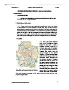
Extreme Environment Report - Cumbria. The aim is to investigate a cold and high attitude environment in high mountains in non tropical latitudes.
EXTREME ENVIRONMENT REPORT - Cold and High attitude 1.0 Introduction .1 Hypothesis and aim: .1.1 The aim is to investigate a cold and high attitude environment in high mountains in non - tropical latitudes. .2 Back Ground information: 1.2.1. These environments are relatively accessible and tend to be viewed as inhospitable to human habitation. Despite this, they provide numerous opportunities for settlement and economic activities. This report examines the essential landscape characteristics of mountains that experienced glaciations during the ice age. It will also investigate the natural processed operating in this area, and the way in which people have responded to the opportunities they offer and the challenges they pose for management and sustainability. .3 Location: 1.3.1 The Lake District National Park is the mountainous region located in the north - west of England (54°35'N, 03°20' E), in Cumbria, just south of Scotland. It's the largest National Park in England and Wales, and the second largest in the United Kingdom. It covers approximately 2,290 km/ 800 square miles. The landscape offers attraction like the highest mountain of England (Scaffel Pike, 978 m). There are 88 water basins throughout the District, 19 are the main lakes, the largest and most central of these is Windermere. The most important cities are located in the eastern part of the region;

Geography fieldwork IA
Globalisation Fieldwork study Report focus: Is there any evidence of the internationalization of commercial/retail activity in Basel, Switzerland? Grade 12 Globalization Fieldwork Study 2008 - Basel Philip Mannas word count: Table of Contents Introduction Aims of Investigation Location map of Switzerland (in the world) Location Map of Switzerland (in Europe) Detailed Map of Basel/site locations definitions of globalization Hypothesis Methodology I Methodology II Analysis of results Evaluations and conclusions Bibliography Appendices A - Random Aisle sampling results B - Price - distance results, Spearman's Correlation Coefficient C - Car Survey raw data D - Random aisle Food Survey raw data E -Land Use Maps F - Regional Map of Switzerland Introduction Basel's location in the heart of Europe, with its land-locked status suggests that it is a country that has evolved around contact and interaction with its neighbors. It is the third largest city in Switzerland and lies at the Rhine which was the initial element for its economic growth and development1. As a result, Switzerland is a country that embraces the need for international co-operation, and acts as good example of a country that interacts with globalization. Figure 1: Central Basel City Source: