The Pampas: The Temperate Grasslands of Argentina
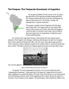
The Pampas: The Temperate Grasslands of Argentina The temperate grasslands of South America are the vast, grassy plain that stretch across Argentina and wander through Brazil and Peru. Being an illustrious part of the South American landscape, the plains are often referred to as “The Pampas”, meaning “flat, unbounded land” in Quechua (Britannica.) The temperate, regulated climate of Argentina makes this region ideal for agriculture. Some regions tend to be more humid, while others are dryer and more arid (Smith), which makes the Pampas as a whole the perfect environment to host a large variety of different plants and animals native to the grasslands, including foxes, giant ant-eaters and Pampas deer. For centuries, native Argentinian horsemen, called Gauchos have been using the natural abundance of the Pampas to their advantage, introducing cattle farming to the land. Once Europeans discovered the potential the Pampas had to offer in the 16th century, they exported large amount of cattle to Argentina in hopes of making a monopoly of the situation (Smith) to economically benefit their home countries. This began to threaten the ecological integrity of the biome as the agriculture became more and more aggressive. Figure 2 A Gaucho herding a group of cattle in the Pampas. (5) According to S.E Smith, overgrazing has caused the rivers to become muddy and murky,

Describe the variations in trade blocs and evaluate the extent to which they promote globalisation.
GEOGRAPHY ESSAY Describe the variations in trade blocs and evaluate the extent to which they promote globalisation. Throughout the world, countries have formed many regional trade blocs over the years, and they play an important role in the world trade and economy. But since they started, their effects on globalisation have been much questioned, as globalisation is the other important current in the world economy development. Globalisation is the increased interconnectedness across the globe, in all political, economic, social and cultural divisions. It describes continuous process by which regional economies, societies and cultures have been integrated through a worldwide network of communication and trade. This process has greatly speeded up in the last two decades as technological progress make it easier for people to travel, communicate and do business internationally. But the term especially refers to economic globalisation. This is precisely the integration of national economies into the international through trade, capital flows, FDI (Foreign Direct Investment), migration… So in this economic context, globalisation refers to the removal of barriers between national borders so as to facilitate the flow of goods, services, capital and labour. Globalisation affects the world in various ways. Economically, it realises a global common market which is based on the
Discuss the concept of food security
Discuss the concept of food security ________________ The WHO defines food security as: “when all people at all times have access to sufficient, safe, nutritious food to maintain a healthy and active life”. This is means that people have both the physical and economic access to food that meets people’s dietary needs as well as food preferences. Food security can be on many different scales at a global, national and household level. However, food security is not global and there is also food insecurity to contend with at for some poorer regions. Global food security was defined by the UN world food conference in 1974 as the availability, at all times, of adequate world supplies of basic food stuffs, to sustain a steady expansion of food consumption globally and to offset fluctuations in production and prices. To an extent this means that food security only exists when all people at all times have access to sufficient, safe and nutritious food to meet their dietary needs and food preferences for an active and healthy life. Due to population increase in some places people are already not getting enough food. Supply and demand also cause problems for the more vulnerable in society, as if prices go up the supply of food should still be affordable for all. National food security is at the smaller scale having enough food available within a country to feed all the people
Describe and evaluate water management strategies (excluding those directed at flood control).
Describe and evaluate water management strategies (excluding those directed at flood control). Over the past 60 years agriculture, industry and domestic use caused an increase of water use from 1000 cubic kilometers to 5000 cubic kilometers per annum. If current trends continue to increase, water shortage will affect 3.5 billion people, 48% of the world’s estimated population, by 2025. In order to prevent water stress to such great extend, measurements and strategies of irrigation and agriculture, freshwater wetland, groundwater and damns and reservoirs were established. Dams and reservoirs certainly are one of the most important water management strategies. The barrier placed across the river Nile and the artificial store that lies right behind the dam together make the Aswan Dam, lying south of the city Aswan in Egypt. Hydroelectric power generation is water being stored behind the dam that drives the turbines and accounts for 45% of Egypt’s energy needed. Moreover, the dam provides water to crops during dry seasons, in times of drought or water scarcity and has irrigated an estimated of 3.4 million hectares of land, which lead to an increasing profit of Egypt’s economy. As well, the Aswan Dam is used to regulate the fall of the Nile up – and downstream, having a better outcome on the navigation of Lake Nasser and on tourism, as the dam became an important

Urbanization and Land Use in New York City
Urbanization and Land Use in New York City ________________ Urban populations and their movement Urbanization is known as the process by which an increasing percentage of a country’s population migrates from rural areas and moves into the town and city. This is called rural to urban migration. Though rural to urban migration is the most common there is also natural increase urbanization. MEDCs like New York City don’t have big growth and growth rate changes such as in LEDC countries. In 1980, 61% of New York immigrants that immigrated to New York were admitted based on family preferences compared to the other 36%. The immigrant’s home countries which are almost always LEDC’s are so poor, usually due to political disorder. This usually results in a high crime rate. Due to all this, the immigrants will flee their country in desperation, which is why they will usually enter a country without the appropriate documents such as their visa. The immigrants that migrated based on family preferences were looking mainly for employment. This was done so that the immigrants could take better care of their families such as better education for their children and better health care and security. Though since these immigrants are so poor they prefer to live in the slums so that their living costs are reduced. The main reason/cause of the increasing population is due to the

Climate change notes
Climate change notes FACTORS THAT AFFECT CLIMATE CHANGE . Atmosphere: A layer of gases that surrounds a planet or moon 2. Weather: Condition of the atmosphere in a specific place at a specific time (describes wind, temp, moisture) 3. Climate: Characteristic weather patterns within a region averaged over a long period of time (Temp, wind velocity) 4. Earth has experienced many climate changes in the past EARTH AND THE SUN . Sun’s energy is the most important factor affecting climate on Earth (winds, rain etc) 2. The amount of radiation produced by the sun varies and a regular solar cycle (sunspot cycle) occurs every 11 years 3. When the number of sunspots is high, the Sun emits higher amounts of solar radiation. 4. Earth rotates tilted (23.5º) on an axis every 24 hrs 5. the combination of Earth’s annual orbit and its tilted axis produces the seasons Revolution: the time it takes for an object to orbit another object . it takes earth 365.24 days to make a complete revolution around the sun CHANGES IN EARTH’S ORBIT . Earth’s orbit, tilt and rotation change in repeating cycles 2. (1) Eccentricity: every 100 000 years, Earth’s orbit changes from circular to elliptical 3. Elliptical orbit means more solar energy for Earth which affects length of seasons 4. (2) Tilt: Earth’s tilt changes every 41000 years by about 2.4º 5. The greater the tilt,

Why do China and Hong Kong have an ageing population? What influence have political decisions had on the population structure of China and Hong Kong?
Sheryl Chan 11.6 Why do China and Hong Kong have an ageing population? What influence have political decisions had on the population structure of China and Hong Kong? “Rising life expectancies and improved health means the population is ageing more slowly and the burden may not be as dramatic as feared, scientists say.” The problem of ageing population is getting worst in Europe and Asia, and China is one of them. China is the largest and most populous country in the world. The world’s population has approximately 6.7 billion people and China has over 1.3 billion which is almost one fifth of the world’s total. Hong Kong has a small number of population compare to the total number of China, and which is about 7.3 million. But if we compare it to the size of Hong Kong, it’s quite a populous place. And this large number of population is caused by the hight birth rate and low death rate. China has a birth rate of 13.71 per 1000 population and death rate of 7.03 per 1000 population. And for Hong Kong, the birth rate is 11.7 per population and death rate is 6.76 per 1000 population. As we can see, the death rate of both China and Hong Kong is almost a half less than the birth rate and this is why they have an aging population. The one child policy in China is the main reason why it has an ageing population and this is also why the problem in Hong Kong is not as serious

Explain what is meant by cultural imperialism.
Explain what is meant by cultural imperialism Cultural imperialism, the practice of promoting the culture or language of one nation in another, has emerged in the 1960s along with other terms of radical criticism. It can take various forms, such as an attitude, a formal policy, military action, so long as it reinforces cultural hegemony. The term “cultural imperialism” is mainly shaped by the three postcolonial theorists Foucalt, Derrida and Said. Within their view, cultural imperialism can be seen as actions contribution to the reshaping of colonialism, often between former colonialist states and their inferior colonies. However, despite actuality of cultural imperialism, the model can be traced back to the Greek and Roman Empires. One major example of cultural imperialism was the “Scramble for Africa”, in which various European countries were involved in the acquisition of colonies in Africa. This stage of cultural imperialism ended during the 20th century when African and Asian colonies gained independence from direct political domination. However, the formal political independence is not necessarily followed by an economic, social or cultural independence. Most colonial powers still exerted a strong economic and cultural power on their former colonies, signified by the use of the same language, currency or political system. For example, even today many former

Antarctica Report - the environment and scientific research
Emperor penguins during summer (Gaidos, 2009) Arial photo of Mawson Station (Australian Antarctic Division, 2012) Emperor penguins swimming near Antarctica (Wienecke, 2011) Contents Report……………………………….………………………....... Pg. 3-8 Introduction……………………………………………........... Pg. 3 Climate…………………...…………………………………..... Pg. 3-5 Location And Purpose Of Mawson Station……………... Pg. 6-8 Adaptions To The Antarctic Environment………………. Pg. 8-10 * Human Adaption…………………………………...………………... Pg. 8-9 * Animal Adaption……………………………...……………………… Pg. 9-10 Conclusion…………………………………………………… Pg. 10 References……………………………………………………… Pg. 11 Appendix…………………………………………………………Pg. 12-17 Antarctica lit up by a colourful aura (Maugans Corporation , 2012) Antarctica Report Introduction: The great icy continent of Antarctica is located at the south-most point on Earth and in the heart of the Antarctic Circle, referred to as the ice-cold desert. Antarctica covers the entire land and water region south of the latitude 600 S with no defined longitude, the

Antarctica Report - The Location And Purpose Of Mawson Station
Emperor penguins during summer (Gaidos, 2009) Arial photo of Mawson Station (Australian Antarctic Division, 2012) Emperor penguins swimming near Antarctica (Wienecke, 2011) Contents Report……………………………….………………………....... Pg. 3-8 Introduction……………………………………………........... Pg. 3 Climate…………………...…………………………………..... Pg. 3-5 Location And Purpose Of Mawson Station……………... Pg. 6-8 Adaptions To The Antarctic Environment………………. Pg. 8-10 * Human Adaption…………………………………...………………... Pg. 8-9 * Animal Adaption……………………………...……………………… Pg. 9-10 Conclusion…………………………………………………… Pg. 10 References……………………………………………………… Pg. 11 Appendix…………………………………………………………Pg. 12-17 Antarctica lit up by a colourful aura (Maugans Corporation , 2012) Antarctica Report Introduction: The great icy continent of Antarctica is located at the south-most point on Earth and in the heart of the Antarctic Circle, referred to as the ice-cold desert. Antarctica covers the entire land and water region south of the latitude 600 S with no defined longitude, the