A clinometer was used in conjunction recording the angle of slope of the sand dunes, enabling the plot of the slope profile shown n the graph paper. This was done by one person stood at the last recorded slope and another at the top or bottom of the next slope. The distance in between was measured and the clinometer was used to estimate the slope of the sand dune.
The other data was recorded using a thermometer to measure air temperature, a soil thermometer used to measure soil temperature.
The pH of the soil was calculated by placing one spatula of barium sulphate (used as the flocculating agent) with one spatula of the soil sample. 5ml of distilled water was used; distilled water was used to prevent any minerals in the water affecting the pH, with finally 1ml of Universal Indicator. The mixture was shuck and left to settle for a few minutes, the results were then read against a pH colour chart.
Results (See graph paper for species cover and slope profile.)
The following graphs show the results for air and soil temperature and soil pH.
The soil colour is an indication of how much humus layer is in the soil, the darker the colour of the soil, the more organic matter it contains. Although we didn’t collect this data, the Sands of Time website did, and I will use their results for additional data.
Discussion
The graph of the plant species percentage cover shows that at different distances from the coast, different species of plants were found. Between 0 and 40m away from the coast, species of sand crouch appeared, which did not occur any further away from the coast. This is because sand crouch is found on embryo dunes as it is suited to the dry, salty sand and is able to grow upwards through accumulating wind-blown sand. The substrate is still extremely inhospitable to plant growth. This can be seen from the colour and pH of the soil, there is little organic substances in the soil and has a high pH. Also along the strand line and the beginning of the strand line, for the first 20m, there is nothing but sand crouch and bare ground, this is because wind speed is high, and the land is dry, salty, unstable and lacking in any plant nutrients. The strand line is unprotected from the wind and unstable conditions. In extreme environments (i.e. closest to the sea), the diversity of organisms is usually low. This may result in an unstable ecosystem in which populations are usually dominated by abiotic factors such as temperature and wind speed.
Moving away from the strand line and further into the comparatively newly formed embryo dunes, the diversity of plant life extends slightly. The marram grass, which is found along nearly every section, begins, and small amounts of ragwort are found, along with still large quantities of bare ground. The plant diversity increases because the distance from the sea has increased, there are also more peaks and troughs providing the land with protection from the adverse conditions. Marram grass is the dominant species present. Bare sand can clearly be seen between the clumps of marram grass. Organic matter is added to the soil from the dead leaves of the marram grass, providing more plant nutrients and increases the soil’s capacity for holding water. The marram grass also protects the dunes by decreasing the wind speed and shelters them from the winds and sea-spray.
This pattern remains the same until about 100m away from the coast, however at 60m the graph shows that the air temperature decreases away from the general upwards trend, this is because at 60m there was a steep slope at approximately 17º. This would expose the top of this dune to higher wind speeds making the air appear colder, this also coincided with a sudden lack of ragwort at 60m. The harsher conditions at this precise point of 60m could change the type of plant species found at this site. The conditions, which vary from others close by, may not suit the conditions needed for ragwort to grow.
Between 100m and 160m, more plant species were found including more marram grass, other grasses and lesser hawk bit. The presence of bare ground still continued. The increase in the diversity of plants can be seen as the pH of the soil decreases as more organic matter is added as dead plant matter adds to the humus layer, thereby increasing the amount of plant life in the area.
Also as the distance away from the sea increases the abiotic factors become less harsh, the air temperature increases, as does the soil temperature and the percentage humidity decreases.
This impacts the plant life and as the distance away from the sea continues to increase, other plant life is found including more varieties of grasses, mouse ear hawkweed, sea buckthorn and evening primrose. Marram grass is still constant and still is the presence of bare ground. This is because our investigation only took us 300m back away from the sea, whereas if a greater distance had been investigated more plant species would have been found including dune heath, scrub plants, and woody trees such as birch and hawthorn.
The abiotic factors also become more favourable for plants as the distance away from the sea increases, the soil pH becomes more acidic and favourable so scrub plants and the organic matter layer becomes deeper providing nutrients to a variety of plant life.
In less hostile environments (i.e. further from the sea), the diversity of organisms is usually high. This may result in a stable ecosystem in which populations are usually dominated by biotic factors such as competition, disease and predation.
Limitations
The techniques that were used to carry out this investigation had their limitations. The transect was difficult to keep in a straight line as there were other groups using the same area of land and the slopes provided difficulties that sometimes were difficult to overcome.
Using the clinometer used merely guesswork and was quite inaccurate, as the wind affected it, giving inaccurate results for the slope profile. Identifying the plants was also difficult as we were not provided with coloured pictures, only black and white ones which made identifying the plants much more difficult.
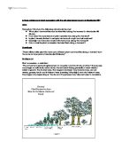
Other limitations included the distance we were able to go, it didn’t reflect the entire succession of the sand dunes, as we only reached perhaps the fixed dunes, however we were not able to go back as far as the scrub and woodland. However if we were to reach the woodland, we would fine that it is not naturally to this succession.
Deciduous woodland is the natural climax vegetation of the dunes and it might be expected to occur on the oldest, landward edge of the dunes. However the dunes have been severely affected by development. The villages of north Hightown, Formby Ainsdale and Birkdale are all built on this older area of the dunes. In addition, large areas of pine woodland were planted in this zone at the turn of the century.