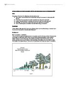
There are different methods of sampling; points, lines (transect) and quadrates. Any of these methods can be arranged in a random, stratified random or systematic way.
In this investigation I used a mix of transect and quadratic methods arranged in a systematic way.
Transect - eg if you are carrying out a survey of moisture levels by soil, along a series of coastal dunes.
Quadrats - find out the proportion of ground covered by a particular plant species eg – woodland or an old abandoned quarry such as the one at Maddocks Hill.
Systematic sampling is regularly spaced where there are variables like in the natural environment, it has an advantage of simplicity. It is better than using random sampling because it’s a fairly featureless area (around a town would be best where land marks are used as guides.
Method
Apparatus Used
2 x 30m tape
Quadrat
Trowel
Light intensity / Soil Moisture Kit
pH Soil Kit
Clinometer
Calculator
Method of Collecting Data
Lay the measuring tape down on the ground from the starting point → as straight as possible.
At the start of each point eg 0m, 10m, 20m place the quadrat parallel to the tape measure.
Record results of:
Light intensity
Soil moisture
Flora (species)
Height of tallest grass
Take a soil sample for pH analysis
When 60m is reached, the 0.5m quadrat is changed to 10x10 using two 30m tape as a right angle
Record all as before and species of trees
Complete all results up to 90metres (9 points)
Method of using pH Kit
- Place 5-10g of dry soil in a test tube. Up to level 2.
- Add barium sulphate up to level 4.
- Add distilled water up to level 6.
- Add universal indicator up to level 7.
- Place bung in tube and shake well.
- Leave tube aside to settle.
- Compare colour of fluid with pH colour chart and determine its pH.
- Repeat a second time for average result.
Method of using clinometers for the measurement of larger trees
- Using a measuring tape, stand five metres away from the tree that needs to be measured.
- Using the clinometer, point it to the highest part of the tree.
- Let the ‘trigger’ go to move the dial.
- When the dial stops moving, release finger from ‘trigger’.
- Looking at the arrow, read the angel at which the clinometer was pointing.
- Record results.
How to calculate tree height using trigonometry
Method for using soil moisture
Insert probe same depth into soil each time
Record results (arbitrary scale used)
Method for using Light Intensity
At each point, point the top vertically
Record the results (H=high etc.)
Results and Interpretation
Figure 1 – Soil pH
These pictures were taken by the digital camera showing the colours of which the soil pH samples came up with.
When testing the soil pH along the transect, a pH probe was used in the soil. However, this always gave a reading of pH7 wherever it was placed. This was a limitating factor, so two soil samples were taken from each plot to be testing chemically back in the lab. This was definitely more accurate.
The pH average for the whole transect was pH 6.36 showing that the soil was slightly acidic. A pH reading between 6.5 and 7 suits the widest range of plants.
There is no trend or pattern within the results, they all fall between pH 6 and 7. One of my aims in this investigation was:
- Is plant diversity limited to entopic factors such as pH and soil moisture?
The results (figure 1) show that pH does not have an effect on plant diversity or how many species grow on each plot. For example, Plot 2 which has a pH of 6.75 compared with Plot 7 which has a pH of 6, both contain the same species, Bush and Kidney Vetch, White Clover and Dandelion. The only difference is that Plot 7 has Butter Bur and Ash trees, but it could be explained by that the plot is at a higher stage of succession (reaching climax) and Plot 2 has just left the stage of the pioneer community.
Within the results there are no anomalous results as all the soils samples along the transect are slightly acidic therefore falling in-between pH 6 and 7.
Figure 2 Soil Moisture
The average soil moisture content for the whole transect was a reading of 2.9.
The trend of the results seem as if the soil moisture is rising arithmetically.
Plot 1 = 2.25
Plot 5 = 3.5
Plot 9 = 4.75
However, within this trend there seem to be some anomalous results;
Plot 3 = 2.5
Plot 4 = 1 (anomalous)
Plot 5 = 3.5
This has also happened further along the transect;
Plot 7 = 4.5
Plot 8 = 1.75 (anomalous)
Plot 9 = 4.75
These results look as if they have affected the amount of species that have been growing on the effected plot eg;
Plot 3 has 7 species
Plot 4 has 4 species
Plot 5 has 9 species
As there is less moisture on plots 4 and 8, it looks as if it may have influenced the amount of species that could grow there. Species may have to compete for moisture resulting in fewer plants being able to grow there. An explanation for the lack of moisture in these plots could be, nearby gorse bushes or Ash tress could have a long complex root system, which, especially Ash Tress, can reach up to 60metres in length. As large tress and plants need more moisture and nutrients, these plots could suffer in not being able to produces as many varieties of plants.
Overall, soil moisture does not have a large effect on what grows along this transect as the readings are not hugely variable. Soil moisture is not a limiting factor for this transect, as it is a short distance. If this investigation was done over a long distance eg a mile, testing every 100metres, then soil moisture might effect what grows on each plot.
Figure 3 Light intensity
There was a definite trend with the results of the light intensity. On each plot where I tested, the light intensity was ‘H’ (High). Like the soil moisture, light wasn’t a limiting factor for these plants.
The apparatus used was definitely limiting as the dial on the kit only pointing to High, Medium or Low. Even by the Ash Tress the reading was still ‘H’ and there was a little shade. To improve the experiment, better equipment could be used to get exact readings. Light intensity could have affected the growth of the plant species on each plot. For example if large bushes or tress shaded an area, different species would grow because they are adapted to the shade.
Figure 4 Percentage Plant Cover
The percentage of plant cover compared to the grass rises arithmetically, which is expected because of plant succession. The plants are becoming more dominant and climaxing. However, there is one anomalous result;
Plot 3 = 30%
Plot 4 = 20% (anomalous result)
Plot 5 = 40%
In Plot 4, the common grass was more dominant that the plant species. From the results table, there are only five species of plant within the plot where in other plots there are more. Plot 4 also had a low moisture content that might have effect on the types of species of plant that grow there.
Figure 4 Random Grass Height
At each plot a random grass height was taken to see how the length varied along the transect. These results have a slight trend. The further up the transect, the longer the grass became.
There is one obvious anomalous result at Plot 5 where the blade of grass is a lot taller than it seems it should be. This could be because of the random grass sample I took, or there could be a lot of nutrients in the soil. As Ash trees are in the same plot as the taller grass, fallen leaves could produce good organic matter for the plants to grow. This could also explain why there are a lot of species of plant within this plot.
Figure 5 Average Tree Height
For Plots 7, 8 and 9 the height of trees was calculated using trigonometry. To obtain an average result, two trees from each plot were recorded. These are the results found
The graph shows the further along the transect, the higher the trees become. This is because of plant succession and towards the end of the transect the plants have reached their climax. There are no anomalous results.
Conclusion
These were my original aims for this investigation:
- What plant communities can be identified along the transect in Maddocks Hill Quarry
- How does the occurrence of plant species vary along the transect?
- Is plant diversity limited to entopic factors such as pH and soil moisture?
- Does light and structure of plant life forms vary along the transect?
- Can a definite plant succession be identified along a transect?
I think that some plant communities can be identified along the transect in three main groups. From Plots 1 to 4 there are simple species. A lot of the species are the same, for example Kidney and Bush Vetch and Dandelions. From Plots 5 to 6 more complex species are taking over, such as Butterbur and Yellow Meadow Vetchling. In Plots 7 to 9 Ash trees have been introduced to the plots as well as the original pioneers species.
Along the transect there are a variety of species. The most common are Kidney and Bush Vetch, Dandelion and White Clover which are found more or less in each plot. Towards the end of the transect in Plots 7 to 9 new species have been introduced such as Stone Bramble, Ash Tress and Melancholy Thistle. This shows plant succession. Also the percentage plant cover that rises in each plot shows this.
In this investigation I don’t think that pH and soil moisture had a big impact on what grew in each plot, as the soil pH was only slightly acidic which most plants are adapted to and can grow well in. If it were very acidic e.g. The Boreal Forest only certain species of plant and tree would be adapted to live in those condition.
Light did not affect what grew along the transect as the results came out the same for each Plot. The apparatus that was used was definitely a limitation.
I think that a definite plant succession can be identified along this transect as there are smaller species at the beginning, growing into more complex ones and then trees being formed towards the end.
Evaluation
There were quite a few limitations in this investigation. When the light intensity results were being collected the equipment used was very restricting as all the time, even in parts of shade, it gave the same reading. As one of my aims was “Does light and structure of plant life forms vary along the transect?” This affected my results as I could not tell if light did influence the growth of plots on the transect and therefore plant succession. Light can be a limiting factor for plant growth, as plants require it for photosynthesis but it wasn’t in this investigation.
Another limitation that occurred was all the results were not taken on the same day. There were two days to the results; first half was taken on one day and the second half on another day. Even though the days looked the same, dry and sunny, it still could have affected the results. For example if it had rained the day or night before, the soil could have more moisture in it on one day than another.
The modifications that I would do to this investigation would include, having better equipment for light intensity to gain a more accurate result. I would also obtain all of my results on the same day so that soil moisture and other factors could not change.
An extension of this study could include comparing the original site to another limestone quarry around the same time as Maddocks Hill was abandoned. Or using the plant succession in this quarry as a plan for recently abandoned quarries around the same climate.
Bibliography
Books
Websites