Conclusion to my questionnaireMany people are put of by being environmentally friendly with cars. This is mainly because they perceive it to be expensive or un-reliable. Toyota now has a problem
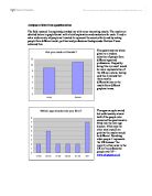
Analyses of data from questionnaires The field research I completed provided me with some interesting results. The results are detailed below in graph format with a brief explanation and evaluation for each. I tried to ask a wide variety of people as I wanted to represent the country fairly and by asking people from different social, political and professional backgrounds I believe I have achieved this. The questionnaires where given to a random selection of people from different ages and professions. I hoped by doing this my result would be more representative of the UK as a whole, having said this I realised that there may be differentiations in the results from different graphical areas. The ages are quite varied but unfortunately almost half of the people who answered the questionnaire fitted into the later age bracket. If this was the other way round I am positive the results would be different. By asking older people it represents the UK because 'the majority of car sales in the UK are to professional people over 35' - www.carpages.co.uk The majority of people I asked did own a car but the opinions of those who don't own cars are still very important as they may be looking to buy within the next year or so. Surprisingly most people said environmental issues ere most important. This may be because modern society has made a demand for more environmentally friendly

Site Surveying Assignment.
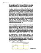
Site Surveying Assignment. Assignment Questions: - A) With the aid of Angular and Distance Measuring Equipment, carry out a closed traverse survey of an area chosen by your Tutor and the group. Plot your survey data using recorded calculations and show all angles and lengths of traverse sides and any corrections. Using latitudes and departures, calculate the area enclosed by your traverse. Check the calculated area by triangulation using sealed dimensions from your closed traverse. B) Woodworth & Sons Ltd have asked your company to carry out the setting out to the building in the plans. As the Trainee Engineer on site, you are required to produce a setting out drawing and explain the practical process of carrying out the setting out details. Assignment: - Check logging sheet for angles and lengths of the traverse survey. Diagrammatic illustration of closed traverse survey (using mean calculated angles) Measurement and correction of the External Angles of the Traverse Survey Mean angles Added STATION EXTERNAL ANGLES A 300? 35' 00" B 241? 27' 31" C 255? 45' 30" D 282? 12' 10" TOTAL 080? 00' 11" The sum of the external angle of a closed traverse = (2n + 4) x 90? Where n = number of traverse stations. Hence sum = (2 x 4 + 4) x 90? = 1080? An error of 30Vn seconds is generally acceptable in surveying for construction/engineering works. If there is a bigger
Resource exploitation is normally a balance between environmental costs and economic benefits. Evaluate the relative geographical costs and economic benefits of exploiting one named resource, which in this essay is oil.
Resource exploitation is normally a balance between environmental costs and economic benefits. Evaluate the relative geographical costs and economic benefits of exploiting one named resource, which in this essay is oil. Exploiting a resource is making the use of something that is not being used, there is a balance between the two because when a resource like oil is being exploited there are many consequences like environmental costs and there are also positive results like economic benefits There are many different Environmental costs, one of the main and most well known is the oil spills, which occur when pumping oil and there is always a risk. In 1999 there was 319 oil spills that is over 50,200 barrels of oil. My Case study will be on Nigeria and all the problems that it faced with the international multi billionaire company Shell and its environmental costs that it is suffering due to the oil resource that they have exploited. Even though I will be writing about Nigeria the problems that occurred in Nigeria are equal to any place in the same situation. The people who own the land that is being used have not received the benefits; this exploitation of oil has only bought pollution of soil and water, health defects, political suppression and violent reaction by the government. Most of the area surrounding and in the middle of all the oil extraction system lack clean
Select an issue in the field of development- for example, trade, aid, gender, children- and discuss how the key development agencies have engaged with the topic over the past 10 years.
Geography Assignment 1 Global Development Select an issue in the field of development- for example, trade, aid, gender, children- and discuss how the key development agencies have engaged with the topic over the past 10 years. "If the misery of the poor be caused not by the laws of nature, but by our institutions, great is our sin" - Charles Darwin (www.quotesgarden.com/poeverty.html) In the year 2000, 80% of the world's population lived in what is known as the poor south and over half of the world's poor lived in Africa. In the last 25 years, Africa is the only continent, which has become poorer; and therefore questions must be asked as to how this has happened. Economists are quick to provide a variety of reasons for Africa's lack of development over the previous 25 years including; borrowing money, growing cash crops, dictatorship, fighting, population growth, land ownership, climate change and dirty water- yet there is no mention of the human cost involved. Darwin therefore may be correct in calling this lack of concern or justice as he sees it, "our great sin". It is this sense of injustice in the world, that has lead to the formation of various development agencies, or non-governmental agencies as they are known, whose purpose when formed was to highlight the extent of poverty in the world to those individuals (namely government officials) that could
Coastal Management CBA Study
Coastal Management CBA Study Introduction Sandbanks is in East Dorset. The beach is widely acclaimed as one of the best beaches in Britain. Historically fragile, Sandbanks is the responsibility of the Borough of Poole who aim to provide long term protection to the infrastructure and properties on the Sandbanks peninsula. To prevent the sea breaking through the Sandbanks peninsula and forming a second Harbour entrance, a series of 13 groynes was constructed in the 1890's. From then until the 1950's, Sandbanks beach steadily became wider, allowing much development. In the 1950's, the old groynes decayed, and were seen as a danger to public safety, so they were removed. Since then the beach has steadily shrunk again. From then on the construction of the along the Sandbanks stretch, together with the various cliff stabilisation schemes, have afforded protection and provided an essential and much valued amenity for both residents and visitors. However, as with most coastal engineering, problems have arisen. The sandy beaches are one of the most prized assets of both Bournemouth and Poole, and they were derived in the first instance from the erosion of the sandy material in the cliffs. Once the cliffs had been stabilised and seawalls and promenades built, an essential link in the coastal process system was broken, since the principal source of the sand was no longer

"The ISO 14000 environmental management series is a major step forward in corporate environmental management" Discuss with particular reference to the ISO 14001 EMS.
ENVIRONMENTAL POLICY & MANAGEMENT 1 Coursework "The ISO 14000 environmental management series is a major step forward in corporate environmental management" Discuss with particular reference to the ISO 14001 EMS INTRODUCTION An environmental management system (EMS) is the system by which a: 'company controls the activities, products and processes that cause, or could cause, environmental impacts and in doing so minimizes the environmental impacts of its operations.'1 From, the onset it was expected that registration under ISO 14001 would become an important business priority.2 It was felt that third party certification would be the vehicle to achieve future business success and a desirable corporate image. Organisations are increasingly concerned with achieving sound environmental performance.3 Moreover, there are growing pressures from national and international sources, such as increasing legislation, financial penalties, environmental disasters and public awareness of sustainability.4 Thus there has been a growing realisation that all organisations have an impact on the environment and that these impacts need to be reduced. ISO 14001 will be introduced as a specification standard and its components will be reviewed. The focus of this report will be to analyse whether ISO 14001 serves as a major step forward. Case studies are used in order to identify the
Examine the influence of habitat diversity and substratum on the composition of macroinvertebrate communities from riverine systems
Examine the influence of habitat diversity and substratum on the composition of macroinvertebrate communities from riverine systems Introduction There have been and continues to be attempts to explain spatial and temporal patterns of diversity in riverine systems (Death and Winterbourne, 1995) and there have been numerous studies aimed at investigating macroinvertebrate community variations. Macroinvertebrate distributions in streams are determined by variations of many factors such as habitat and food availability, substratum, hydraulic structure and channel morphology, which create distinct morphological units within streams. (Church 1996; Giller and Malmqvist, 1998). Three main habitat types have been identified: erosional, depositional and with macrophytes, habitats which are more commonly referred to as riffles, pools and runs. (Jenkins et al., 1984; Buffagni et al., 2000) The majority of academic study has concluded that the run-riffle habitat supports the highest number of taxa while the lowest is that of the backwater habitats and that riffles are more diverse than pools (Brown and Brussock, 1991[2]; Logan and Brooker, 1983; Buffagni et al., 2000; Hynes, 1970: Scullion et al., 1982; Armitage et al., 1974; Death and Winterbourne, 1995; Costa et al., 2008). Although some studies in the mountain stream channel form reported equal or more species abundance and
Conservation management of water in raised mires and lowland wet grasslands
Conservation management of water in raised mires and lowland wet grasslands Introduction Wetlands make up 6% of the earth¹s land surface and in the past, people had misconceptions about them. The only policy for management was to drain them, but nowadays, the emphasis is on protection. A wetland has a water level high enough to force vegetation to survive for a significant time in anaerobic conditions. Britain has relied on land drainage to become agriculturally productive and habitable; 61% of its agricultural land has been drained. Wetlands though are amongst the most fertile ecosystems on the planet, providing numerous advantages to humans, such as the ability to cleanse water, remove pollutants, and provide peat, an organic fuel. They also provide fish, food, and stores for floodwater. This report aims to concentrate on the water requirements of two wetlands, lowland wet grasslands and the raised mire. Lowland wet grasslands, such as the Somerset Levels, include wet meadows, a traditional farming system from the 16th century. Their decline began with the quickening of the pace of conversion to arable land coupled with intensified land management. Britain originally had 1,200,000 hectares of wet grassland, but this is now only 220,000, of which only 20,000 is agriculturally unimproved of a high conservation value. To save this ecosystem, a positive and sympathetic water
The islands of Texel and Schiermonnikoog have different and similar intrinsic values. Discuss these intrinsic values and how they may influence the Dutch attitudes towards the implementation of coastal protection and management in these islands
"The islands of Texel and Schiermonnikoog have different and similar intrinsic values. Discuss these intrinsic values and how they may influence the Dutch attitudes towards the implementation of coastal protection and management in these islands." Situated in the very north of the Netherlands are the five Dutch Wadden Islands of Texel, Vlieland, Terschelling, Ameland, and Schiermonnikoog. These islands rest in the Wadden Sea, "Europe's largest and most important marine wetland". (Enemark., J. 2003, p1). Stretching from 'Den Helder, The Netherlands to Blåvandshuk, Denmark and covering an area of 13,500km2' (De Jong, F., et. al., 1999), the Wadden Sea region presents a high level of potential interest through availability of multi-use capacities. Economical interest is reflected in the gas and oil extraction, which is a prominent activity. It is estimated that Dutch gas reserves in this region amount to 72-221 billion m3 (De Jong, F., et. al., 1999). Followed by this, the area is an important shipping route with several main shipping ports located along the Wadden Islands. The shrimp and shellfish fisheries are also another activity, which are mostly processed and traded in the Netherlands (De Jong, F., et. al., 1999). On an ecological front, important bivalve habitations are located here, with many interests in the floating articulated bivalves (Cadée., 2001). It has also

Internal Stucture of the Earth
Briony Cavanagh GEOS112 ASSIGNMENT TWO: INTERNAL STRUCTURE OF THE EARTH. Figure 1: Hildyard. R, (2010), Earth Structure. Available at: http://www.leeds.ac.uk/ruskinrocks/Earth%20Structure.html It is not possible to directly observe what the internal structure of our Earth is like as it becomes too hot for human intervention, as shown from volcanic eruptions. Figure 1 (Hildyard, 2010) shows the current model for the internal structure of the Earth. This model demonstrates that the planet has layers: the crust, the mantle and the core (outer and inner). Without having this direct observation of what lies beneath the surface and with our deepest hole being only 12km (Coffey, 2010), scientists have had to rely mainly on both indirect and direct methods such as the analysis of earthquake body waves, drill holes, volcanic eruptions and meteorite studies. From monitoring earthquake waves and applying our knowledge of wave properties such as refracting and speed, scientists can gain a greater understanding of the structure of the Earth’s interior. There are three types of seismic waves that enable us to create a model of the interior of the Earth: P-Waves, S-waves and surface waves. P waves have the ability to move through all materials, being solids, liquids and gases. They are longitudinal compression waves that are propagated by particles moving longitudinally in the same