Risk is not only affected by the probability and severity of the hazard, but as can be seen from the equation above is also influenced by the Vulnerability of the people and the environment in which they live. Moreover also how much or how long they are exposed to the hazard. Furthermore risk can be illustrated more than an equation, it can be seen graphically as a function of the three elements in a risk triangle proposed by (Crichton, 2001) and shown below (Fig.1). The diagram illustrates the importance of assessing the three elements as a system as well as the need for each element to be assessed separately.
Fig. 1. Crichton’s risk triangle (Crichton, 2001).
Through effective risk analysis of the hazard and vulnerability of the people and infrastructure in the area, areas most at risk can be designated in turn decreasing the vulnerability of people. This problem in context of the Kashmir region is that the region has a notably high frequency of earthquakes, and landslides are very common in the region, only the most severe of these trigger the scale of landslides seen in the 2005 event.
Tectonic forces drive the Eurasian plate and Indian subcontinent together at a destructive plate boundary. Shallow focused earthquakes occur often as the denser Eurasian plate slides beneath the Indian plate and melts in the subduction zone.
The earthquake occurred on the 8th October at 8:50am local time. The moment magnitude of the earthquake was measured as 7.6, and ruptured along the Muzzaffarabad fault and Tanda fault, the hypocentre is disputed with (Purnachandra Rao et al., 2006) claiming it was 26km below the surface and (USGS, 2005) with 10km. the exact focal depth of the tremor is still in dispute. The earthquake triggered landslides covered an estimated area of 7,500km². The epicentre of the earthquake was 34°29’35”N 73°37’44”E, 19 miles NE of Muzaffarabad, in the Pakistan controlled area of Kashmir.
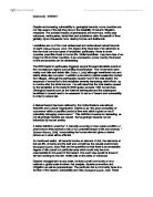
Fig.2. (A) Image showing part of the study area (adapted after Calkins et al., 1975; Hussain and Khan, 1996; Hussain et al., 2004) (B) Image showing the region of most extensive land sliding. (Geographical Survey Institute, 2006; Avouac et al., 2006).
Landslides are one of the most prevalent hazards in the Himalayas, and are particularly deadly here as people rely on the fertile soils the Himalayan mountain ranges provide and will be the focus hazard I will assess in terms of vulnerability and hazard. The factors influencing mass movements in the Himalayan region are: -
- The high relief of the land with ranges reaching 4500m above sea level. Steep lower valleys slopes due to fluvial incision with angles exceeding 50°. Above the lower valley slopes lie hill slopes which are generally less steep before being replaced by the high glaciated summit slopes.
- The topography – high mountain peaks dissected by the main valley floors at between 500 – 2000m asl. The region is drained by the Jhelum River and its two tributaries, the kunhar and Neelum rivers. The three rivers have high velocity and discharge rates, so have greater erosional capabilities.
-
The climate –the region has a subtropical highland climate. Muzzaffarabad receives 1500mm of precipitation on average(U.Kamp et al, 2008), of which one third falls as rain during the monsoon season lasting from late June till the end of august.
In the context of the Kashmir landslides, there were other contributing factors. Human activity had a degree of impact on the stability of the soil through road constriction and deforestation. As well as the strength of the underlying bedrock, active erosional processes such as freeze thaw weathering can also affect the types of landslides occurring in the region.
Most of the landslides triggered by the earthquake were rock and debris falls. (Classified by Varnes, 1978); their sizes ranged from singular boulders to extensive failures covering thousands of square kilometers. Debris slides and debris flows also occurred throughout the region. Most of the failures were shallow, typically involving the top few metres of weathered bedrock, regolith and soil. The landslides triggered by the seismic event clustered in distinct geomorphic-geologic settings.
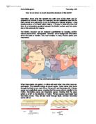
The Hittian Bala landslide Marked with a white circle (Fig.3.) was the largest single failure of the whole region. The landslide occurred in the Parhore valley, burying the villages of Nainan, Buthsher, Bale and Lodhiabad. The landslide blocked the valley and the debris was 130 metres deep in places. The rock fall blocked the Karli River completely and works had to be undertaken to create a benched spillway in the blockage.
Fig. 3. Image showing the main study area (taken 27 October 2005) showing the location of the epicentre of the Kashmir earthquake and highlighting the areas of main land sliding.
The image above shows the 6 distinct geographic settings of the landslides. (Owen et el. 2008) noted that many of the slopes throughout the region showed little evidence of land sliding or fissuring. They showed the relatively stable slopes occurred on gradients of less than 20° and in the footwall rocks of the Major Boundary Thrust (MBT). (Owen et el. 2008) concluded that although earthquake triggered landslides are extensive throughout the region from the epicenter, they are concentrated in specific zones (Fig.2.) associated with the bedrock geology, geomorphology, topography and human factors of that specific area.
Landslides limited to a 25km long belt of thin bedded highly fractured dolomite, extending from 5km SW of Muzzaffarabad in a NW-SE direction. (Fig.2A) shows the scale of the belt. The slope failures were mainly rock falls with a few exceptions of debris falls. Slides occurred on steep valley slides with angles greater than 50° above rivers or alluvial valley fills.
Landslides occurred along the natural lower valley slopes; the valley slopes commonly being less than 50° and having long stretches that rose from actively eroding streams. Most failures were rock falls and slides although debris falls were common.
Natural failures in the high and fluavially cleaved and highly fractured rocks of the Hazara formation. The cleavage is tightly folded and pencil cleavages have developed at some locations, most evident at the Lamnian valley and its tributary to the north side of the Jhelum Rivers, west of Muzzaffarabad.
This landslide setting is confined to the very steep (»50°) lower slopes of the quaternary valley fills that have been undercut by rivers and streams. Most of the failures were debris falls producing talus cones and slips that reached the streams and formed rapids. The failures were generally small, comprising of areas of debris that wee 100m wide and long.
Mainly smaller rock falls occurred here with areas of less than 100m². Rock slides were common on the ridge and spur crests, landslides after were extensive on the mid-slope regions. Extensive fissuring is present on the mid-slope regions, with the most extensive fissuring associated with the Muzaffarabad formation.
Land siding was most common along the roads that commonly exceeded slopes of 50°. Poor road construction including cut and fill methods, were one side of the slope is completely excavated have weakened slopes. The steep cuts and adjacent slopes have failed along nearly every stretch of road.
The distribution of landslides shown above (Fig.3) supports views that earthquake triggered landslides are most abundant throughout an extensive area from the epicenter, but are concentrated in specific geological zones (Owen et el. 2008). If these zones are identified, then local governments can implement planning strategies to prevent building and land use in these areas. Mitigation strategies such as these require investment in he first place in order to facilitate offices, staff and resources, but would reduce the vulnerability in the long term.
Once these areas have been identified, warnings and information regarding these hazards can be passed to local communities living in close exposure to the hazard zones, land use planning could prevent construction in and around areas of high risk or unstable lithology.
Geographical-information-system mapping (GIS) technology can provide landslide susceptibility maps in order to identify the areas most at risk from land slope failures, these techniques are based on the lithology, topography and climate of the area.
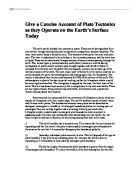
An example of landslide susceptibility mapping is shown below (Fig.4.); a study by (U.Kamp et al, 2008) found that two-thirds of the study area has a low or moderate risk of future land sliding, while the other third has a high or very high risk of slope failure. The highest susceptibility of future landslides lies in the regions underlain by the Muzaffarabad formation. The diagram shows not only high risk of future slope failures where human activity such as road conduction and deforestation have been rife, but also in close proximity to faults and rivers.
Fig. 4. Landslide susceptibility map of our 2005 Kashmir earthquake study area from U.Kamp et al, 2008
Mitigation measures to modify vulnerability in the short term are not costly, but their feasibility and efficiency is often underestimated. Short term strategies of preventing mass movement in the Himalayas involve planting trees and removing moisture from the soil structure to decrease the probability of soil liquefaction and thus the chance of occurrence, but these measures could fail in the event of strong seismic activity.
Crichton’s risk triangle (Crichton, 2001) explores not only the concepts of risk and vulnerability, but the concept of exposure as well. This model applies better to this hazard as exposure was a key factor in the Kashmir landslides. Millions of people were made homeless before the harsh Himalayan winter. The landslides blocked key routes to many small villages and causing localised flooding in many parts of the region. Helicopters and light air craft were the only effective form of evacuation. The road blocks made getting heavy machinery through to more isolated communities a logistical nightmare.
Decreasing the vulnerability of getting cut off from vital supplies could be reduced in the future by building a second road lower in the valley floors were few landslides occurred. By reducing the risk of getting cut off, the communities are not modifying the hazard but this will still benefit people in case of such an event.
Modifying the risk of the triggering hazard in this scenario, the earthquake, is not possible. Modifying vulnerability to the landslide events however is, and by reducing vulnerability, people are not exposed to the hazard. In light of this region being poorer and so able to spend less money on mitigation measures, more money should be spent on risk analysis and prediction. Landslides are one of the most predictable geological hazards (Jones and Lee, 1994), but they only become a hazard when they interact with humans.
If accurate risk susceptibility maps are produced then the geographic regions at most risk can be identified, and governments should incorporate such maps in order to implement land use strategy. In terms of hazard X vulnerability, if effective disaster management including risk analyses and risk maps are used to good effect, then the vulnerability of the communities will be reduced, in turn reducing the risk of the hazard and minimizing any exposure. Although each element of the equation has to be assessed separately in order to understand how one affects the other, but one important point is; If one element in the equation is reduced, it will reduce the other.
References:
Journals
- Owen, L.A., Kamp, U., Khattak, G.A., Harp, E.L., Keefer, D.K., Bauer, M.A., 2008. Landslides triggered by the October 8, 2005, Kashmir earthquake. Geomorphology 94, p1–9.
- Kamp, U., Growley, J., Khattak, G., Owen, L., 2008. GIS-based landslide susceptibility mapping for the 2005 Kashmir Earthquake Region. Geomorphology 101, p631-642.
- Kunlong, Y., Lixia, C., Guirong, z., 2007, Regional Landslide Hazard warning and risk assessment. Earth science frontiers, 14(6): 85-97.
- Westen, C., Castellanos, E., Kuriakose, S., 2008, Spatial data for landslide susceptibility, hazard and vulnerability assessment: An overview. Engineering geology, Netherlands.
-
Dunning, S.A., Mitchell, W.A., Rosser, D.N., Petley, D.N. 2007, The Hittian Bala rock avalanche and associated landslides triggered by the Kashmir Earthquake 0f 8th October 2005. Engineering geology 93, 130-144.
- Fedeski, M. Gwilliam, J. 2007: Urban sustainability in the presence of flood and geological hazards: The development of a GIS-based vulnerability and risk assessment methodology. Landscape and urban planning, 883, 50-61.
- Kamp, U, Owen, L.A., Growley, J., Khattak, G., in preparation. Landslides initiated by earthquakes, snowmelt and monsoonal rainfall in the Kashmir Himalaya, Geomorphology.
Key texts
- Bell, F.G. 2003. Geological hazards: their assessment, avoidance and mitigation. Spon Press, London.
-
Bolt, B.A.2004. Earthquakes.5th edition. Freeman, New York.
- Allison, R.J. 2001. Applied Geomorphology: Theory and practice. Wiley.
- Carson, M.A. and Kirkby, M.J. 1972. Hill slope Form and Process. Cambridge.
- McGuire, B. Mason, I. & Kilburn, C. 2002. Natural hazards and Environmental change. Hodder Headline group, London.
Websites
-
- Disaster Management in the context of Hazard, Vulnerability and Risk.
-
- THE GEOHAZARDS IGOS.
-
- Online science Glossary.