Mount Vesuvius; an assessment of the present day situation.
Emily Beedham Student Number 020178417 Mount Vesuvius; an assessment of the present day situation A volcano is generally defined as, "a vent or chimney that connects a reservoir of molten matter, known as magma, in the depths of the crust of the Earth, with the surface (Sheets and Grayson 1979:11)." The material ejected through the vent frequently amasses around the opening and builds up a cone. This expelled material usually consists of rock remains, liquid lava and great quantities of gases; these gases are the driving force behind any volcanic action (Bullard 1962:8). Mount Vesuvius is a volcano, "located on the shore of the Bay of Naples, in central Italy (Sheets and Grayson 1979:29)," and is, part of a series of volcanoes that form, "a trend that parallels with the west coast of Italy, extending north from Naples through Rome to Sierra (Richter 1986:1)." Eruptive activity at Mount Vesuvius alternates between cycles of action and repose, both lasting several centuries; these cycles are usually initiated with a Plinian eruption. An example is the infamous eruption of A.D. 79 that not only destroyed the towns of Pompeii and Herculaneum, but also half the cone of Vesuvius - the present day Vesuvius consists of, "an old strato-volcano (Mount Somma) which terminated its activity with a summit caldera collapse, and the recent cone (Mount Vesuvius) that has grown inside the

A discussion of the eruption Mt. Helena in 1980
A discussion of the eruption Mt. Helena in 1980 Over the past fifteen years substantial developments have been made within high magnitude-low frequency volcanology. It is now becoming increasingly possible to predict an eruption; to understand the processes of eruptions and to develop relevant responses and adjustment programmes (Chester 1993, McCall 1992, White 1972). Yet, regardless of this there are problems. Although science has developed new prediction methods, the accuracy of these is hard to judge, as despite frequent high magnitude-low frequency eruptions during the holocene, they are now relatively rare, thus making adjustment programmes problematic. Volcanologists have however, decided upon two types of programmes (McCall 1992). Firstly, predicting the volcano's future eruptions, carried out through studying past behaviour and secondly, setting up permanent monitoring systems allowing for rapid detection of new seismic activity. General global programmes cannot be augmented however, but, in the aftermath of an eruption the responses and adjustment made can be assessed and can be used as guidelines for future high magnitude-low frequency volcanic areas. The Mount Saint Helens' eruption was one of high magnitude-low frequency and consequently other countries have turned to the responses and adjustments made by Washington State to develop their own programmes. This

Plate Tectonics (notes)
Plate Tectonics - Transform Margins o When plates slide past each other o E.g., San Andreas fault (called right lateral) o Offsets between ridge segments in mid ocean ridge system caused by transform faults - Hot Spots - These are areas of upwelling where the magma upwells in plumes that originate deep in the lower mantle (ca. 670 km below the surface). These plumes stay fixed, while the lithospheric plates move above them. - Ca. 50 to 100 hotspots, figure in book shows the locations. - We are most familiar with the example of the HI island chain. - Overview: production is matched by destruction o When destruction of old ocean plate, deep trenches - Part of sedimentary layer rides atop the ocean plate incorporated into overriding plate o Lithospheric plates that have both ocean and continent: e.g. No. America. Made up of continent and oceanic lithosphere to east- continues to the mid ocean ridge. - Passive continental margin - Broad, gently seaward-dipping continental shelf o Continental lithosphere is welded onto the oceanic beneath the continental shelf - Active continental margin - Ocean - continent boundary is convergent margin therefore a subduction site. Pacific coast of No-West American What drives Plate Tectonics? Geothermal heat flux - heat escapes to the surface mostly through mantle convection Origin of heat in Earth's interior: .
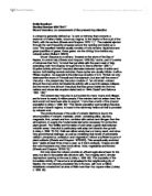
Give a Concise Account of Plate Tectonics as they Operate on the Earth's Surface Today
Give a Concise Account of Plate Tectonics as they Operate on the Earth's Surface Today The earth can be divided into concentric layers. These can be distinguished from one another through varying chemical composition, temperature, density and phase. The inner most central body is called the core. This consists of two parts: the inner and outer core. The inner is understood to be solid due to the immense pressures, and the outer core is liquid. Phase can be determined through analysis of seismic waves passing through the earth. Two waves types; p (compressional) and s (shear) waves are emitted during earthquakes. S waves cannot however pass through liquids, and therefore if data is collected from stations over the globe of an earthquake, a picture can be built up of the internal structure of the earth. The next major layer of the earth is the mantle, and this too can be divided into parts: the asthenosphere and layered upon this, the lithosphere. The mantle is less dense than the core and accounts for 82% of the volume of the earth. The asthenosphere is plastic like due to partial melting, unlike the lithosphere which is solid but semi-rigid and can flex. The lithosphere is capped by the crust, the final layer of the earth. This is a less dense layer and very thin in comparison to the core and mantle. There are two types of crust, being oceanic and continental. Continental
The societal impacts from the eruption of Mount Saint Helens May 18th, 1980
Case Study: The societal impacts from the eruption of Mount Saint Helens May 18th, 1980 Benjamin Sellers Due: 11-26-02 GG. 300 Preface Location: Washington, United States Latitude: 46.20 N Longitude: 122.18 W Height: 2,549 meters or 8,364 feet - 9,677 feet before May 18, 1980 Type: Stratovolcano The problem with volcanic eruptions has to do with there unpredictability and overall capability. A volcano is very unpredictable, even when it is heavily monitored there is no sure way to predict an exact time, however the field of volcanology is advancing in technology and knowledge to aid in this problem. Also, the capability of a volcano when compared to other natural disasters is very subtle and versatile. The versatility of destruction ranges from an eruption to a mudflow or from a landslide to ash plumes large enough to carry ash massive distances which in turn creates many other of its own significant problems. The subtle capability of volcano lies in its unpredictability, like only being able to make an educated guess for an eruption time it is even a greater challenge to predict the times and geometric characteristics of its secondary effects. This next information may be unrelated preliminary information, to the specific impact of Mt. St. Helens but it is an absolute necessity that the uneducated individual becomes educated; this is the best defense against an
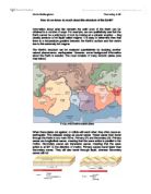
How do we know so much about the structure of the Earth?
Chris Bellingham Thursday 4:00 How do we know so much about the structure of the Earth? Information about what lies beneath the solid crust of the Earth can be obtained in a number of ways. For example, we can qualitatively see that the Earth cannot be a solid lump of rock by looking at a volcanic eruption - they usually produce a hot liquid called magma. It is easy to determine then that there is a temperature gradient between the Earth's surface and the centre due to this extremely hot magma. The Earth's structure can be analysed quantitatively by studying another natural phenomenon, earthquakes. However, some background information about the Earth is needed. The crust consists of many tectonic plates (see map below) A map of the Earth's tectonic plates When these plates rub against, or collide with each other, they often cause an earthquake. This releases energy as sound waves. These waves then travel through the Earth in two main forms, Primary (P) and Secondary (S). Primary waves are longitudinal waves, meaning that the wave action is parallel to the motion. Secondary waves are transverse waves, meaning that the wave action is at 90? to the direction of motion. Primary waves travel faster than Secondary waves. They will also travel through liquid, whereas Secondary waves will not. We can look at how these waves travel (or do not travel) through the Earth and
"A complete understanding of the extent and chronology of Quaternary glaciation requires evidence from both terrestrial and marine evidence - discuss."
"A complete understanding of the extent and chronology of Quaternary glaciation requires evidence from both terrestrial and marine evidence - discuss." "Just as you cannot see your own footprint in the sand while your foot is covering it, you cannot see the effects of an active glacier at its base or sides. Only when the ice melts is its geological work of erosion and sedimentation revealed." -Press and Siever 2000- Introduction The effects of glaciations in the last quaternary were global, thus information about them is hidden both terrestrially and in marine sediments. They type of information revealed in each of these areas varies both in detail and in what information they actually give. Depending on what information you require, it may be worth focusing on one particular information source. However, it may not be regarded as wise to do this, as you may inhibit your ability to obtain a complete understanding. It is marine sediment analysis that was first used to study Quaternary environments, with the first piston corers being developed in the USA in 1945 (kingdom drilling 2004). With the aid of improved technologies for coring materials and data analysis, it could be said that scientists from then were encouraged to look at other sources of information (i.e. cores from ice sheets) for an even broader source range. Marine Evidence Ocean sediments provide a very
geohazards the kashmiri earthquake 2005
Despite an increasing vulnerability to geological hazards, some countries are not fully aware of the risk they face or the feasibility of hazard mitigation measures. The societal impacts of geohazards are enormous, every year volcanoes, earthquakes, landslides and subsidence claim thousands of lives globally, injure thousands more, destroy homes and livelihoods. Landslides are on of the most widespread and undervalued natural hazards on earth (Natural Hazards. 2002). The reason they have less of an attraction is that the most common types of landslides, particularly those in richer countries pose little threat to human life. Whilst landslides may have less of an impact on life in richer countries, in an unprepared, poorer country the impact on life and property can be devastating. The 2005 Kashmir earthquake triggered several thousand landslide events in the mountainous regions surrounding Muzaffarabad. The movements were mainly rock falls and debris falls (Kamp, U, 2008) although transitional rock and debris slides also occurred. In addition a sturzstrom (debris avalanche) buried four villages. Although the earthquake caused most of the total deaths, the sequence of events led to the landslides severely hampering relief efforts up to months after the initial tremors. It is estimated that the total deaths caused by the landslides in the Kashmir 2005 quake exceeds 1000
Pembrokeshire Geology Field Trip Report. The Caerfai shale has a red/pink colour due to the presence of oxidised iron
Pembrokeshire Geology Field Trip CAMBRIAN The Cambrian rocks in the area of Pembrokeshire can be divided into 3 stratigraphic ranges. These consist of Lower, Middle and Upper Cambrian. Each originates from marine conditions, mainly of shallow marine sediments deposited on the southern shelf margin of the Welsh Basin. The Lingula Flags Formation, Menevian Group, Solva Group and Caerfai Group represent the Cambrian ranges of Pembrokeshire (in the order of youngest first). Caerfai Group (Lower-Cambrian) This group consists of Basal Conglomerate, St Non’s Sandstone, Caerfai Bay Shales and Caerbwdy Sandstone. The Basal Conglomerate is a reddish coloured sedimentary rock that has clear joints and bedding planes. There are large clasts that are present in the rock which are approximately 1 – 20cm in diameter. These are quartz, feldspar and rhyolite flow bands. The rock is classed as a conglomerate as the clasts are held in a finer matrix. Calcite mineral veins were also visible on the rock face. Larger clasts were present at the top of the rock and smaller clasts at the bottom making it a transgressive sequence. The Caerfai shale has a red/pink colour due to the presence of oxidised iron. It is a fine-grained sedimentary rock with some mineral veins present. The mineral veins are approximately 3cm thick. Crystaline tuff is present throughout the rock, which is