Texel (figure 2) being the westernmost and largest of the West Frisian Islands, with an area of approximately 71 square miles (Answers.com., 2006), is an island that is reasonably well developed. Its history of prosperity sprung from the Dutch ‘golden age’, where it became the centre for international shipping for ships on their way to Amsterdam. After French domination, Texel became agrarian specialising in Texelaar sheep, renowned for their good muscles and lean meat. Nowadays there is a heavy reliance on tourism amounting to 75% of the economy in 2000 (Field Notebook., 2006). This has lead to the development of increased infrastructure and harbours. Hotels, camp sites, and other developments have been established in order to support this tourism. Furthermore, resident numbers have increased and thus housing development has occurred putting stress on the space. Other activities in this island include off-shore gas exploration which operates just off the island of Texel, along with fisheries. Over recent years this island has become no longer self-sufficient, import most provisions from the mainland.
Not only has the use value changed but so has the island’s geomorphological structure. Its history of coastal protection dates back to 1630 ‘Zanddijk’ between the old land of Texel and Eierland, after a period of intense flooding during the 1620s. This consequently led to polderisation and the joining of the two islands, increasing its agricultural value. However, the island is still under threat from the strong waves and currents from the North Sea which encourage upon the coast, stripping sediment away. This has caused near shore sand to be eroded and subsequent lowering of the beach. This is especially the case for the northern tip of Texel, Cocksdorp Beach, where until recently this region receded by 6-8 metres per year (Meijer., 1999). This consequently leads to the denudation of dune ecosystems. Importantly, these dunes play a vital role in maintaining a natural barrier between sea and land, known as dune dijks, and if these are under threat then the polders behind them are in jeopardy, leading to potentially devastating consequences on the ecology and economy of the island.
Figure 2 – Map of Texel with inset
(Google Earth., 2006)
A similar story is reflected in Schiermonnikoog (Figure 3), the last of the West Frisian Islands. Schiermonnikoog is the smallest island, approximately 25 square miles, with only one town and a relatively undeveloped infrastructure. The inhabitant number is low and so is economic activity, relying mainly on tourism. However its ecological potential is very high with half of the listed flora in the Netherlands being found in this region (Field Notebook., 2006). It is also a very well established back-barrier salt marsh, ‘relatively undisturbed by the presence of man’ (Wijnen., and Bakker., 2000). The problem this island faces is three-fold. Firstly, the currents and waves of the Wadden and North Sea, in addition to the winds, is leading to the south-easterly migration and ‘thinning-out’ of the island. In 1250, the island lay 2 km north of its current position (Wikipedia., 2006). Secondly, the dijk systems that were installed during the 1960’s are failing and subsequently during high tides, part of the Schiermonnikoog national park is allowed to be flooded, possibly at the expense of ecology. Thirdly, sea level rise is posing a significant threat to elevation of the salt marsh. Currently Mean High Tide in Schiermonnikoog is 1 metre above Normaal Amsterdams Peil (NAP) (Wijnen., and Bakker., 2000), which is causing accretion rates to increase leading, consequently with increased elevation sediment inundation decreases. In addition, the clay layer shrinks during the summer months followed by compaction under its increased weight causing a elevation deficit It is predicted that marsh accelerated degeneration of marsh will occur in response to sea level rise and thus more tidal floodings will occur (Wijnen., and Bakker., 2000).
Figure 3 – Map of Schiermonnikoog with inset
(Google Earth., 2006)
Both Texel and Schiermonnikoog are suffering from coastal erosion, influenced by tides and waves from the North Sea. However, in hindsight there intrinsic backgrounds differ. Texel offers greater diversity in multi-use capabilities, where economic activity is very dominant in this island. Schiermonnikoog presents a region dominated by the protection of the ecologically, although tourism is present, but not on such a scale as Texel. But which island is receiving the most attention concerning its coastal erosion? Which stakeholders have the choice in coastline management? Is there any bias in the decision making?
In realisation of that increased populations and multi-user activities amongst Wadden Islands may imperil the sustainability of the Wadden Sea region, the Trilateral Wadden Sea Plant was established in 1997 between the territories of the Wadden Islands, Denmark, Germany and the Netherlands. This agreement sets a common vision of Wadden Sea integrated coastal management, where all ‘policies, measures, projects and actions must be agreed upon by all members to achieve commonly agreed targets.’ (De Jong, F., et. al., 1999). This agreement stretches from Den Helder, Netherlands to Blåvandshuk, Denmark (Figure 4), indeed Texel and Schiermoonikoog fall within this agreement. Its aim is to ‘achieve a natural and sustainable ecosystem in which natural processes occur in an undisturbed way’ (De Jong, F., et. al., 1999).
Figure 2 - The extent of the Wadden Area Plan and Conservation Area
(De Jong, F., et. al., 1999. p20)
The Wadden Sea Plan has many principles including the principle of avoidance; careful decision making; translocation; restoration and best available techniques. Stakeholders, for example local populations and traditional users are to have their interests weighted on a fair, unbiased way. To what extent does this theory get placed into practice? Is it possible that some interest groups’ voices may not hold as much weight as others? The interest groups may never be able to assess whether or not their views have been treated equally. Conservation sites have been established within the Dutch Wadden Sea area under the Wadden Sea Memorandum. However, it is important to highlight that human use is given priority, an attitude that shows that use value influences management policies. This notion may possibly be reflected in all trilateral countries and not necessarily the Dutch.
In accordance with the trilateral policy, coastal protection in the Netherlands is based on best Environmental Practice. Brushwood groynes have been common practise, along with the idea of stimulating vegetation growth, a major factor in sedimentation rates. (Dijkema., et. al., 1995 cited in De Jong, F., et. al., 1999). In exceptional circumstances, ‘hard’ methods of coastal protection may be used, for example extensive replenishment or damming. However, there is ambiguity over what constitutes ‘exceptional circumstances’. Could Texel be the case study for an exceptional circumstance? Although there is a common policy for all the Wadden Islands, some islands do get treated differently in accordance with their ‘use’ value.
Coastal protection and Management in Texel, has been based on the theory of dynamic preservation, the maintenance the seaward boundary at its position in 1990. (Anon., 1990 cited in De Ruig., 1998) This theory has been applied through the application of beach nourishment schemes. Since 1970, 50 different beach nourishment programs have been implemented involving the use of 70 million m3 of sand. More importantly, a factor that highlights the value of this island to the Dutch is that of the response to the Governmental report on systematic coastal management in 1989. Out of four alternatives, the Dutch chose the second most expensive option, ‘alternative three’; where the coastline is to be preserved at its 1990 position. During the period of 1991-1995, 6.6 million m3 of sand was used to maintain the coast of Texel (De Jong, F., et. al., 1999). This programme comes at a cost of 60 million guilders per year (Meijer., 1999), which is probably set to increase in relation to sea level rise and increased erosion rates. Noticeably, Texel has received the most beach nourishment out of the West Frisian Islands, in terms of frequency and volume (Table 1).
Table 1 Nourishment operation for the 1990-2000 decade.
(EUROSION., (n.d)., p12)
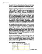
Furthermore, ‘harsher’ coastal engineering methods have been use, for instance the ‘super groyne’ on Cocksdorp beach, built in 1995. With 3 metre deep foundations and a protrusion of 550 metres seaward, the groyne consists of 117,000 tonnes of Norwegian bitumen and granite (Meijer., 1999; Field Notebook., 2006). It came a cost of 8 million Euro (EUROSION., (n.d)). Its aim was to recapture the lost sand caused by the tidal stream between Texel and Vlieland, decreasing the quantity of sand need to replenish the coast by 80% (Meijer., 1999). The visual results since the implementation of this coastal defence can be seen in figure 1.
Figure 1 – The effects after the installation of the Texel ‘super groyne’
(EUROSION., (n.d). p15)
With such a large and extreme scale of coastal defence and engineering, Dutch attitudes highlight that this place is worth fighting for. Surprisingly the trilateral policy on coastal protection advocates the harmonisation between nature protection and sea defence measures. With evidence of such ‘hard’ and obtrusive coastal measures, does this not contradict the guidelines of the trilateral policy? Questionably, what is being defended, the coast or the economy? Indeed tourism is very important in this Island, and is popular with the Dutch and Germans. With no beach or very little beach, the numbers of tourists would decline and consequently so would the economy. Furthermore to this, infrastructure and settlement in this region would suffer from a catastrophic flood. But also their are the dune systems to consider in terms of their ecology; do these really have such an importance in this island? Therefore, this island may represent an area of high priority concerning coastal defence. The chance of ‘risk taking’ with ‘hands-off’ management has not been given consideration.
Schiermonnikoog has a very different style of coastal management. The eastern part of the island is uninhabited and thus requires very little maintenance (CPSL., 2001). The island has a vast landscape of dune ecosystems, salt mashes and mudflats. Attitudes towards coastal defence in this island have not been as hard-lined as Texel, with little need for anthropogenic intervention. Schiermonnikoog’s coastal management is centred on the dynamics of ‘nature’, where it is left to its own devises to act as a sea defence, as this island is considered to be a ‘low risk’ area concerning coastal defence. Its history of management dates back to 1959, where a ‘five metre sand dijk was constructed in order to suppress the influence of the sea and to encourage plant colonisation on the island’ (EUCC., 2000). Since then the dijk systems have dilapidated. Since 1972 there has been a cessation on the management most of the dijk systems. There is a management issue as to whether not to either maintain the dijks or allow nature to take its course. The latter would consequently lead to irregular flooding and sand mobility (EUCC., 2000). However, it is hoped that flooding will put stress on the environment and encourage further biodiversity and discourage stabilisation, this in turn would formulate a method of ‘natural’ sea defence. In response to the recommended reduction in live grazing in salt marsh area from the Wadden Sea QSR, 1999, the salt marshes on Schiermonnikoog have had increased canopy size and thus able to accrete sediment. Therefore, under this management marshes will be able to keep up with the pace of sea level rise and soil subsidence attributed to off-shore gas and oil exploration (CWSS., 2005). However there is a possibility that some of the ecology would be lost as a result of these actions, but it is human intervention that may also cause the denudation of the salt marshes and dune ecosystems, by encouraging stability. It appears in this case that no action results in the island naturally defending itself.
The picture of Schiermonnikoog highlights that ecology does have importance. The measures adopted to protect it are much ‘softer’, indeed there is the ‘hands-off’ management in this region. Notably, dune dijks in this island are capable of withstanding a 1:10,000 year storm, (Verhagen., et. al., (n.d.), thus they are invaluable in natural coastal defence. Not much is known about the results of these actions and subsequent monitoring is taking place. It is apparent that the actions in Schiermonnikoog are in line with the trilateral policy. However, is this the best available technique in coastal management or an excuse to avoid protection in an island that does not have a high poplation distribution.In a cost-benefit analysis, this island and the measures involved to protect it is far less.
In conclusion, it has been highlighted in the case studies that coastline line management varies between the two islands and is the result of coastal zone management practise in the Netherlands. It is apparent that the island methods of coastline management reflect the level of ‘naturalness’ of the landscape. Texel has shown a reworked landscape with high levels of development as a response of the numerous interest groups. This in-turn has shaped the island’s intrinsic value and its level of importance. In terms of coastal defence, the landscape may not loan itself to ‘natural’ methods and it may also be ‘risky’ practice, as much of the island would suffer if this method were to fail. Instead, ‘hard’ coastal management is used in order to satisfy and secure human use. In theory the Dutch are sticking to what they know best in response to the interest groups, reflecting the attitude that man is a battle with the sea.
Schiermonnikoog appears to be an area of trial and error, a place where ‘risk’ is less and where ‘hard’ measures may conflict with the homogeneity of the local environment. Indeed, who is to be harmed when ‘natural’ coastal management fails? With less to offer in terms of use value, the island has become a sanctuary for the ‘natural’. Indeed natural processes and management are favoured, because it maybe the influence of man’s coastal defence mechanisms that may create man-made coastal problems later on. The Dutch attitude here is one that works in collaboration with the sea. In terms of economics it far cheaper to maintain this island.
References:
Bridgewater, P., 2003. Keynote address by Peter Bridgewater, Secretary General, Ramsar Convention. [Online]. Trilateral Wadden Sea Cooperation 25th Anniversary Celebration, October 22, 2003, Wilhelmshaven, Germany.
Available from: . [Cited 5 March 2006]
De Jong, F., et. al., 1999. 1999 Wadden Sea Quality Status Report. Wadden Sea Ecosystem No. 9. Common Sea Secretariat, Trilateral Monitoring and Assessment Group, Quality Status Report Group. [Online]. Wilhelmshaven, Germany.
Available from: [Cited 6 March 2006].
De Ruig, J., 1998. Coastline management in The Netherlands: human use versus natural dynamics. Journal of Coastal Conservation, 4, pp. 127-134
Staatsbosbeheer., 2006. Texel 2006. [Pamphlet]. Staatsbosbeheer – Duinen van Texel.
EUCC., 2000. Restoration of natural dynamics in a foredune-area on Schiermonnikoog, Dutch Wadden Sea. European Union for Coastal Conservation. [Online]. (Updated 7 June 2000).
Available from: [Cited 5th March]
EUROSION., (n.d.). Wadden Sea Islands (The Netherlands). [Online]. The Hague, Netherlands.
Available from:
[Cited 5 March 2000]
Field Notebook., 2006. Netherlands Field Notebook. University of Glamorgan.
CWSS., 2005. Coastal Protection and Sea Level Rise: Solutions for sustainable coastal protection in the Wadden Sea Region. [Online] Common Wadden Sea secretariat, Wilhelmshaven, Germany.
Available from: [Cited 6 March 2006]
CPSL., 2001. Final Report of the Trilateral Working Group on Coastal Protection and Sea Level Rise. Wadden Sea Ecosystem No. 13. [Online]Common Wadden Sea Secretariat, Wilhelmshaven, Germany.
Available from: [Cited 6 March 2006]
Enemark, J., 2003. The Wadden Sea protection and management scheme – towards an integrated coastal management approach? Ocean and Coastal Management 48 (2005) pp. 996-1015
Verhagen, H., et. al. (n.d.) Dutch approach to coastline management. [Online]. The Netherlands. Availabel from:
[Cited 6 March 2006]
Wijnen, H., and Bakker, J., 2001. Long-term Surface Elevation Change in Salt Marshes: a Prediction of Marsh Reposnse to Future Sea Level Rise. Estuarine, Coastal and Shelf Science. (2001), 52, pp. 381-390.
Cadée, G., 2002. Floating articulated bivalves, Texel, North Sea. Palaeogeography, Palaeoclimatology, Palaeoecology. (2002), 183, pp. 355-359.
Meijer, H., 1999. Maintaining the Netherlands coast. Geography Review, March, pp. 12-15
Wikipedia., 2006. Schiermonnikoog. [Online]. (Updated 24 January 2006).
Availbale from: [Cited 6 March 2006]
Answers.com., 2006. Texel. [Online].
Available from: [Cited 6 March 2006]