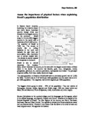
The vast area around the Amazon basin is the most sparsely populated with less than one person per sq km. Most of the people live in Belem, Macapa and Manaus, along the river where there are 10 to 49 people per sq km.
Population density of 1 to 9 people per sq km is seen in most of the Central-West, most of the North-East, going towards the interior and along the Amazon River in the North regions.
There are many factors affecting the population distribution in a country. The reasons for this in Brazil are historic and colonial, physical landscape and environment, economy, farming and industry, society and culture and political decisions. The pattern seen in the population density map of Brazil can be explained using those factors and the relation between them.
The first European settlers in these lands were the Portuguese who, led by the adventurous Pedro Cabral in 1500 began the colonial period. They found about 7 million native Indians who had limited agriculture and temporary dwellings. The Portuguese were not focused on conquering, controlling and developing the country. These mainly impoverished sailors were far more interested in profitable trade and subsistence agriculture. That is why the country’s interior remained unexplored whereas the coasts saw the establishment of many cities such as Salvador and Sao Paolo. The colonists started capturing and selling slaves. They discovered that the land and the climate along the coast were ideal for growing sugar cane. In the mid-1600s, men from Sao Paolo, usually born of Indian mothers in the interior, reached the peaks of the Peruvian Andes and secured the huge interior of South America for Portuguese Brazil.
During the 17th century the importation of African slaves started. They replaced the Indians on the plantations.
In the 1690s gold was discovered in the South-Central part and the movement of people from the coastal regions to the interior began. Many immigrants from Europe also arrived. This led to a demand for farmers to supply mining centres.
The invasion of Dutch and French armies in the North-East lasted throughout the 18h century.
In 1807, Napoleon’s army marched on Lisbon and soon he made Rio de Janeiro the capital and the Portuguese government was transferred there.
In the 19th century, coffee took the place of sugar as Brazil’s most important product. Its production brought a wave of almost a million European immigrants, mostly Italian.
Brazil is divided into three regions, based on broadly similar features. They are the North, Central-West, North-East, South-East and Southern Regions (map 4).
The North region is largely covered by lush, tropical rainforests. It is situated mostly within the Amazon basin where the Amazon River and the other rivers in the area form the place with the largest concentration of fresh water in the world.
The annual average temperature is 22°C to 26°C with very small seasonal variation. The most intense rain falls near upper Amazonia and Belem.
In any given square mile of Amazonia, up to 3000 species of plant life can be found, which makes it difficult to for people to live and even penetrate into the rain forest.
A region with sparse population is the Central-West. It is covered with extensive savannas and tropical grasslands. The landscapes are mainly hills and rivers. Well-distributed rainfall is seen in this area. Here is the Mato Grosso swampland which is the wildlife paradise.
The North-East region contains nearly 30% of Brazil’s population. The west stretches are chronically subject to drought. They are also called the polygon of drought. The inconsistent rainfall with its very high evaporation rate is due to the fact that this place below the equator is the hottest part of Brazil at 38°C. The mountains along the coastal area trigger rainfall from the Trade Winds. In the South of Salvador the lands are drier because the rain falls in the mountains. The predominant vegetation in the semi-arid North-East is a dry bush called the coatinga. This region sees a greater seasonal variation than in the North region.
About 44% of Brazil’s population lives in the South-East region. It is composed of two highlands: the Atlantic Plateau and the Meridianal Plateau with mountain regions.
This area, rich in minerals and natural resources, has the most advanced agriculture in the country. It has the second largest reserve of iron in Brazil. Calcium, zinc, gold and mineral water are also seen. Important production of cotton, soy, orange, coffee, banana, maize, potatoes and tomatoes is seen in São Paulo – the commercial centre of the country.
The South-East has mild climates averaging 19°C in the Plateau cities of São Paulo, Brasilia and Belo Horizonte. On the coast, Rio de Janeiro has warm climate, balanced by the constancy of the Trade Winds, normally 23°C to 27°C. Sao Paulo also sees heavy rainfall. This region has very nutritious soil.
Below the tropic of Capricorn is the South Region. It has a warm, temperate climate but on the coast distinct cooler seasons can produce frosts. The area is often affected by invasions of cold air from the Antarctic, but in summer the temperatures can rise to levels similar to the tropical regions. Towards the south, the Plateau drops to the wide plains called pampas. The South is home to one of the most beautiful natural wonders of the world – the Iguacu Falls. Here, on the Parana River is the largest hydroelectric dam in the world – Itaipu.
90% of the country is within the tropical zone, where 60% of the population lives on plateaus and mountains, along the coastline where the seas winds and polar front moderate the temperature. Mild climate averaging 19°C are seen in the Plateau cities such as São Paulo, Brazilia and Belo Horizonte. The Trade Winds balance constantly the warm climates of Rio de Janeiro, Recife and Salvador. Temperatures fall below freezing in the subtropical climate of southern Brazilian cities of Porto Alegre and Curitiba. Map 6 shows the average temperature in January. The summer lasts from December to February. The temperatures are over 30°C. The south is hot and humid. The North-East is drier with fresh tropical breezes.
The average temperature in July is shown in map 7. The winter season in Brazil lasts from June to August. In winter, only the southern states fall below 20°C. The rest of the country has moderate temperatures.
The most intense rainfall is found around the mouth of the Amazon River (map 8). Belem is one of the wettest cities in the world. Another important region of heavy rainfall is the state of São Paulo, along the edge of the GrSeat Escarpment.
The undependable rainfall in the “Polygon of Drought” is a reason for the very high evaporation rate in the North-East. This makes it difficult to grow crops.
Along the coastline, near Recife, São Paulo and Brazilia are spread the arable lands which are suitable for growing crops. These places are very densely populated.
Coffee, cocoa, soybeans, sugarcane, wheat, rice, corn, citrus, beet and tobacco are the main agricultural products of Brazil. They are mainly exported to other countries, such as the US, Argentina, Germany, Netherlands and Japan.
Huge coffee plantations on the Southern coast were planted in the age of exploration in Brazil, around 1640-1650. Tobacco is raised in the Southern region. Map 9 clearly shows the arable lands spread along the coastline. Moving towards the interior, we can see that cattle are raised there. In the South-East, the three cities of Belo Horizonte, Rio de Janeiro and São Paulo form the biggest industrial area of Brazil called the “Industrial Triangle”. This supports almost all the industry of Brazil, resulting in population decrease elsewhere in this region.
Brazil’s main industries are textiles, shoes, cement, lumber, iron ore, tin, steel, aircraft, motor vehicles and parts, and other machinery and equipment. The development of technology in the country is poor there is a need to import many types of machinery and equipment. The country also imports chemicals, oil and electricity. The import partners of Brazil are he US, followed by Argentina and Germany.
Map 10 shows the areas with woods and forests where lands are most arable. Therefore these places are more sparsely populated because the industry is poor.
The population in Brazil since 1500 to 1900 has increased slowly from 5 to 17 million. After this it started to grow rapidly and in 1950 it was 50 million. Only 30 years later the number of people doubled and now, in 2003, it reached 172 million people.
In 1950, 37% of the population was living in towns and 66% in the countryside. The trends continued and in 1991, 70% were living in the towns and 30% in the countryside.
Back in the 16th century the Portuguese came and settled mostly along the east. The indigenous population lived in the forests in the North-West and along the rivers. In 1870 half of the population lived in the North along the fertile “Zona de Mata” where the sugar cane was planted.
The Royal Family of Brazil set up the court in Rio de Janeiro which allowed the immigrants to come. Many poor Europeans came to work in the coffee plantations. During the period between 1884 and 1973, 1.5 million Italians settled in São Paulo, 0.5 million Spanish came into the country and 0.2 million Germans set up their own farms in the South (South Cadomina, Rio Grande du Sul).
When the “gold rush” began in 1690, men from the North settled along the Amazon River with their families. This became the city of Manaus.
The main religion in Brazil is Catholicism. The influence of the Church on population rates is modest. The wealthier families have less children when it suits them and the rural poor have large families either because they want them or through lack of access to effective family planning.
In 1959, the president Juscelino Kubitschek established the Sudene in Brazil. This is the Superintendence for the Development of the Northeast. During military dictatorship the Sudene was continued by President Costa de Silva. He promoted industry in this region. The proportion of industry growth was: in 1960- 12% and in 1976- 30%. Now the president Lula de Silvera announced the reestablishment of Sudene (map 11).
Since 1960, Brasilia is the capital city of Brazil. It was built for a period of only 4 years, starting 1956 by President Juscelino Kubitschek. It was an inaugurated as Brazil’s capital in 1960. Lucio Costa won the national contest for design of the city, with a proposal for an aeroplane design. The master plan was for only 500 000 inhabitants but the population has seen its grow much higher than expected. That is why several satellite towns were created for the extra people. The population of Brazil is now 2 million people.
Built to reduce inequalities and develop inlands, Brasilia has all of the federal government buildings. It firmly established itself as a capital city during military dictatorship.
The population density of Brazil is mainly a consequence of the physical factors. The history, the economy and especially the farming and industry are all dependent on the geography, climate and soils which allow growing crops. The industry of a country forms in paces rich in minerals and natural resources. People tend to live near the mines and farms, so they can work and then sell and export their products.
The first settlers on the Brazilian land used its soils to grow coffee and sugar cane. Later when they discovered gold in the area more immigrants came for the “gold rush”. The tropical rain forests along the Amazon basin are hard to penetrate in. industry cannot be raised in these places.
These examples show that the physical factors are very important for the population distribution throughout the country. They are not the only important factors, but without them the others could not happen.