Mount Pinatubo, Philippines, June 1991
Before the eruption:
- Not erupted since 1380 (dormant volcano)
- Mt Pinatubo is located on the main Philippine island of Luzon
- Area surrounding Mt Pinatubo was excellent for rice growing (weathered ash & lava).
- Volcano monitored by the Americans from the nearby Clark Air Base using scientific equipment such as seismometers, tiltmeters and a GPS.
Cause of the eruption:
- The Philippines lies on a destructive plate margin
- Philippines Plate (oceanic crust) is subducted under the Eurasian Plate (continental crust)
- The oceanic crust is turned into magma, rises, and erupts on the surface
Eruption Details
- From 9th June 1991 there were many eruptions and earthquakes
- Biggest eruption was around midday on 12th June 1991:
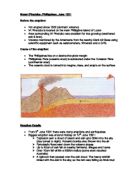
- Explosion sent a cloud of steam and ash upto 30km into the sky (day turned to night). Volcanic bombs also thrown into the air
- Pyroclastic flows went down the volcano slopes
- Up to 50cm of ash fell on nearby farmland, villages and towns
- Over 10cm fell within a 600km radius (some even reached Australia)
- A typhoon then passed over the ash cloud. The heavy rainfall mixed with the ash in the sky, so the rain was falling as thick mud
- A lahar was generated, which travelled as far as Angeles City (20km away)