Eating and Drinking
Kingston Upon Thames has many restaurants and cafes from a large variety of origins, Indian, Chinese, Mexican or Italian. After the riverfront was re-developed many restaurants located there to become high end eating areas. The concentration of public houses is in the north of Kingston Upon Thames, a few examples are: Wych Elm and Willoughby Arms.
Sports
Kingston has two football associations called Kingstonian F.C. and AFC Wimbledon, both of which play at the Kingsmeadow Stadium. Kingston Rugby Club is based on the edge of the town and Kingston Rowing Club is based on the River Thames with a Regatta taking place every July.
Education
There are many schools is Kingston, these include:
- Kingston Grammar School
- Canbury School, Marymount International School (MMI)
- Tiffin School (boys)
- Tiffin Girls' School
- Educare Small School.
There are two universities called Kingston University and Kingston College.
Transport
Kingston Upon Thames is one of the main centers of the southwest London bus network, and it is connected to Twickenham, Richmond, Wimbledon, and London Waterloo by overground train. The local stations that exist for Kingston Upon Thames are: Kingston and Norbiton.
Also, Riverboats run regularly between Kingston and Hampton Court on the River Thames.
Why I chose to study this topic
I chose this topic as human geography interests me more than physical geography, as I live in the city it makes more sense for me to investigate the town I live near rather than travelled to a park. Also I felt that collecting data in a busy town would be safer than collecting data in a park. Additionally, I think that collecting secondary information for a town would be easier than a park. Moreover I felt that I could complete this topic in the time I was allowed.
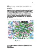
How is Kingston Upon Thames useful to investigate in relation to the topic?
This investigation links to the “Settlements” part of the GCSE Geography course. Kingston Upon Thames is helpful when investigating my topic because it is near my home and I could easily revisit the study site if I realized that I had forgotten to collect some data. Additionally Kingston Upon Thames is a well-known shopping centre and a bridging point, this attracts many people to the city everyday, this means that doing questionnaires and pedestrian counts will be easy as there will be many pedestrians to question and count. Also, I studied it briefly in class and hence already knew background information about it.
Geographical Theory
In order to help me make a prediction for the results of my hypotheses that I stated on the previous page I had to use geographical knowledge. The CBD is clearly defined into two separate sections, the core and the frame.
The model on the next page shows the structure of a typical CBD. It is split into two distinct sections, the core, where land is used intensively and is taken full advantage of. This encourages vertical development as the price of land is incredibly high as there is not much space in the centre of the city. This area contains large department stores and specialist shops. This causes the core to have a large amount of pedestrians during the daytime when shops are open. The outer core and frame has a slightly lower land value. This refers to the bid-rent theory as the closer you get to the centre of the CBD the higher the value of land. Many businessmen compete for land as close to the CBD as possible hence raising the price of land. This is because of its easy accessibility and high volumes of pedestrians and traffic; this makes it easier for businesses to thrive. If Kingston Upon Thames is a typical CBD its town should have the same plan as the diagram on the next page.
Another model that helped me make predictions for my hypotheses is an Urban Land Use Model called The Burgess Model.
This diagram shows the theoretical land uses of the areas in a city located in a developing country. The CBD is usually the oldest and most accessible part of the city, this is because companies and business usually start to expand and spread out as the city gets richer meaning that the newest parts of the city will be around the edge of the model. Almost all cities follow this pattern of expansion. Often the different zones develop due to social and economic factors. This is because in some cases planners have tried to separate land uses, for example airports generally separated from large housing estates. The model also shows a clear relationship between houses and distance from the CBD. The further from the CBD the house is situated the better the quality of housing but the longer the commuting time to reach the CBD. Even though this diagram is simple and good at helping students understand basic concepts, it has many limitations. For example, the diagram does not account for the idea that gentrification has changed the quality of housing in the inner city. Kingston Upon Thames and the surrounding area should have the same plan as figure 2 if it is a typical CBD.
A settlement hierarchy is when settlements are placed into an order of importance based on their size or the services that they provide for people. As shown in the diagram as you go higher up the hierarchy there is an increase in the size of the settlement as well as the number of services and the population. Additionally, the number of settlements of each type decreases as you move further up the settlement hierarchy as there are more hamlets compared to capital cities. The city’s importance in also based on its sphere of influence. This is the area served by one certain settlement. The size of this will depend on the type and also number of services the town provides and additionally the size of the town and how accessible the it is, for example rail link, motorways and bus stops. Villages usually provide a small number services, and these are mainly low order services or sell low order goods. Example of low order goods and services are that they are required everyday, for example bread or milk or the local newsagents. Larger towns and services will have a bigger number and range of services this usually includes low order and high order goods and services. Examples of high order good are furniture and some clothes. People are willing to travel further to get these items, as they are more expensive. For shops to succeed they need to have a certain number of regular costumers this is known as the threshold population. Usually high order goods need a larger threshold population to be profitable. Taking all these factors into account, I think Kingston Upon Thames would be classified as a large town.
All this geographical theory and knowledge stated above and on previous pages helped me make predictions for my hypotheses.
Hypotheses
In order to investigate my aim I needed to answer the followed question or hypotheses:
1. Comparison shops will be clustered together near the centre and convenience shops will be dispersed near the frame
Comparison shops will be clustered. Their range and threshold population are a lot bigger compared to convenience stores. Also convenience shops are only for everyday use so many people go to the nearest shop available so if they are dispersed they serve more people. This is because convenience shops do not want to compete with each other and they want their own sphere of influence. Additionally in order for comparison shops to accommodate their large threshold population they need to be situated in an area that is easily accessible and has a large amount of pedestrians. This is found in the city centre perhaps explaining why there is several comparison shops clustered together in the city centre.
2. i) Low environmental quality, especially at point 1 in the map
ii) High shopping quality, especially at point 6 on the map.
In the CBD there is a concentration of offices, entertainment facilities and traffic. This itself causes a huge amount of air and noise pollution. However, the CBD has a huge amount of pedestrians meaning that a large amount of land pollution will be created as well. There are usually a variety of different high standard shopping facilities in CBD’s this is because the CBD is easily accessible. So businesses tend to thrive there. The CBD also needs to compete with out of town shopping centers to prevent Urban Decline. Kingston Upon Thames does this well with Bentalls Centre, John Lewis and the Clarence Street.
3) i) Very high amount of traffic especially at point 5 on the map
ii) Similarly high number of pedestrians especially at point 6 on the map
As there is a lack of space, streets are narrow and many converge when they enter the CBD, also car ownership has increased greatly in the recent years and the current street network is not designed to cope with the huge number of vehicles using it. This means that many CBDs suffer gridlock during rush hour. Many people come to the CBD in order to work and shop as many large offices and shopping centers are situated here. This is because of the high accessibility helping the businesses succeed. These points are toward the centre of the CBD, known as the core. The diagram of the core and frame of a CBD is shown on Page 3.
4) i) The sphere of influence will be more than 10km
ii) The majority of people will be coming to Kingston Upon Thames to buy clothes
There are a wide variety of shopping facilities available in Kingston Upon Thames. Also it is highly accessible because there are large amounts of public services and transport offered there. Additionally there is a huge amount of parking space; this encourages more people to go to Kingston Upon Thames. Many people will come to Kingston to shop because of the huge mulity story shopping mall, Bentalls Centre as well as the pedestrianised road, full with shops, Clarence Street.