Drought in the Sahel Belt
ACTIVITY 5:
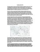
The Sahel belt is a region in western Africa, forming a transition zone between the arid Sahara on the north and the wetter tropical areas of the south. The Sahel belt runs from Mauritania in the west to Chad in the east. The video which I watched, focused on the Sahel belt in a part of Burkino Faso. A relatively sparse Savanna vegetation of grasses and shrubs predominates. Rainfall averages between 102 and 203mm (4 and 8inches) a year and falls mostly from June to September; periods of low rainfall and drought are common, however. An extended drought in the Sahel, lasting from the late 1960's until the early 1980's the worst in 150 years, suggested and increasingly arid regional climate. Its effects were exacerbated, however, by the fact that unbalanced development projects-which allowed the size of cattle herds to increase as a result of better veterinary practices and the digging of wells, without a compensating increase in the marketing of the cattle-had led to overstocking and overgrazing in an extremely fragile environment. Nomadic herding and limited cultivation of peanuts and millet are possible in most areas in years of normal rain.