Many of the buildings in the CBD are for commercial purposes and there are few residential buildings, firstly due to the high price of the land and secondly the CBD is a very congested area and if homeowners had children and the children played outside they would have a high risk of getting hurt unless if the houses/flats had gardens is highly unlikely due to the high price of the land in the CBD the people who live in the CBD, in the many new
Flats are normally young urban professionals, with no children. To find out the centre of the CBD of Leeds I am also going to use our group data that we collected as individuals and shared with the geography sets, to help us all map the whole CBD, As a group we recorded changes in building height, the land use of the buildings as the centre of the CBD is more likely to be where a lot of shops and office are found. We recorded pedestrian flows to help to find the CBD of Leeds as high numbers will determine where it is the busiest e.g. near the centre if the CBD, We did our pedestrian flow outside the Town Hall in my group.
I also am going to use the data I have collected from doing my two primary data investigations which were an environmental quality assessment and traffic count also I am going to use secondary data to see if land value decreases with distance from the CBD, I will also do an environment quality assessment, which will show the centre of the CBD by the cleanliness of the shopping street looking at traffic flows. I can identify the centre of the CBD as there will be more traffic, the closer you are to the centre of the CBD. The value of the land decreases away from the CBD and knowing land values will show us the centre of the CBD as the centre of the CBD will be in the most area of expensive land in the CBD. The CBD will join with the frame as the land value decreases. At the edges there are fewer retail stores than in the core.
In the Burgess model which was based on Chicago, the city has grown outwards from the middle.
There are five zones with the CBD as the centre zone of the city. The inner zone is the CBD and this is where the price of land is highest in the city/town and is dominated by commercial and retailing buildings. Then just outside the CBD it’s where all the disused factories or buildings are, it is normally known as the brown field site also it is now usually in a state of decline or transition. In Leeds, the area has been redeveloped in some parts e.g. along rive Aire as there are lots of flats and offices replacing the old brown field site. Outside the disused factories and buildings is the old inner city area, where there is low class residential as there are lots of council estates and this is where the factory workers used to live in the early 20th century. Outside the inner city area is the inter-war period and this was when semi-detached housing was built and they normally have gardens with the housing and are normally on large estates. There is also a high concentration of council owned housing and the furthest area from the CBD is the modern suburbs, this is where there is private, high quality housing with large gardens and garages also they can contain a commuter zone which is at the very edge of the city. I think this is in some cases a good model as the zones are in the right places of a CBD but all the zones are not circular. The centre of the CBD will mainly contain retail/department stores and the frame of the CBD will mainly have transport terminals and multi storey car parks as the land value is higher in the centre of the CBD and is cheaper in the frame.
The Hoyt model has land use concentrated in wedges or sectors radiating out from the city centre. For example, factories may be concentrated along a river, canal or road to form a zone of industry. This would attract low-class housing, but repel high-class residential land
Use. The CBD is in the centre of the model and then the blue wedges are the factories which are concentrated along rivers, canals. Rail lines or roads. The low class residential is near the factories as it saves commuting costs. The middle class residential is further away than the factories/industry and the high class residential is located upwind away from the industry/factories and the low residential districts. I do not think this is like Leeds CBD as there are high, middle and low class residential areas all over Leeds not just in a specific area.
The 3 hypotheses that I am investigating are:
-
The nearer to the centre of the CBD, the taller the buildings - the reason regarding why I chose building height is because most cities have the tallest buildings in the CBD, because it is less expensive to build upwards and would make best use of the site, so there would be a higher number of tall buildings in the centre of the CBD as the land is more expensive there. The group data that we collected when we measured building heights will help me in this hypotheses.
-
There will be a higher volume of pedestrians nearer the centre of the CBD - The reason of me choosing this hypotheses is that most cities CBD’s are for commercial use and in the core of the CBD it is busy with lots of people work and shop. Therefore there will be lots of pedestrians will help me in these hypotheses.
- The traffic flow will be busier in the center of the CBD - more people work in the centre of the CBD as the shops are more clustered in the CBD and people need to travel through the CBD and the group data that we did when we counted pedestrian flows also the primary data when I did about traffic counts will help me investigate this hypotheses’.
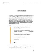
The image above shows the zones of many CBDs across the world.
In the inner core of the CBD is where most of the tall buildings are and they are mainly department stores, commercial offices e.g. banks, tall office blocks and specialist shops e.g. jewellers, due to the high price of land the building are taller. In the inner core there is where offices e.g. solicitors, cinemas and smaller shops e.g. newsagents. In the frame there is the zone of discard and zone of assimilation, these zones is where there are many run down shops and many people do not enjoy going to these zones as in the zone of assimilation the buildings are being drawn into CBD usage and There may also be a zone of degradation where the buildings are changing from CBD usage to residential land use, also in the frame there is lots of schools, car sales e.t.c. and in zone a there is high quality residential property unlike zone b where there is poor residential and lots of industry.
Leeds CBD is a very good one to study about because it is big and a variety of shops, offices, public buildings, retail/department stores e.t.c and is more challenging to find the centre of a CBD like Leeds rather than the CBD of a smaller town like Keighley where it would be easy to find the centre of the smaller CBD. Also as I live in Leeds I can revisit Leeds and gather more data but Keighleys CBD is further away and is harder and longer to get access to Also finding the centre of the CBD is not just more challenging than delimiting the CBD but it is more fun finding the centre of the CBD rather than delimiting the CBD as the pedestrian flows and traffic counts will be much more less delimiting Leeds CBD than in the centre of the CBD as more people work in the center of the CBD of Leeds and most people go near the centre of the CBD for their work then near or in the frame of Leeds CBD. I am also going to produce land use maps which will make my investigation easier to find the centre of the CBD of Leeds and the height of buildings is taller near the centre of the CBD and the height will decrease as they go away from the centre of the CBD.
Bibliography