The Sahel is an area of poor savanna grassland with scattered trees and shrubs which stretches 5000km from Senegal and Mauritania on the Atlantic coast to Chad and portions of Sudan and Ethiopia in the east. On a vegetation map of Africa, this zone is marked as savannah grassland, a transition area between the arid desert to the north and the more humid wood lands to the south. On a map of Africa annual average rainfall the zone can be taken as the lying between the 100mm and 600mm isohyets. The surface wind circulation and the seasonality of rainfall in this part of the Western Sahara and Sahel is very largely determined by interactions two high pressure systems and the inter-tropical convergence zone (ITCZ).
The pressure systems are known as the Azores high and the Saharan high. The ITCZ is a frontal zone which marks the meeting place between warm, moist air from the Gulf of Guinea to the south and hot, dry Saharan air to the north. This ITCZ moves north and south with the seasons. When a town is further away from the ITCZ the warm air in that town has enough height here to rise, cool and form clouds and rain. But if a town was near the ITCZ then there would be not enough for air rise and to give rain. In recent years the ITCZ, pressure belts and wet winds have not been moving so far north. So towns like Burkina Faso in the Sahel have not been receiving much summer rain. This may be because of global warming giving greater strength to the hot air from Sahara, to move further south, than normal.
In the winter months the Azores high is close to the African coastline and the Saharan high is strong. While the ITCZ is at its southern position over the Gulf of Guinea. The circulation from the two pressures systems creates a wind flow that is from the north-east over much of the Western Sahara. These are moisture. During the first six months of the year these hot, dry winds generate fierce dust storms in Mauritania, blowing loose soil, sand and clay particles from the dry unvegetated land surfaces.
In the summer months, the Saharan high is replaced by a shallow low pressure system in the central Sahara and the Azores high is strong and further from the coast, giving more northerly winds at most stations. During the period from June to September the ITCZ is also at its most northerly position, so that the Sahalian areas of the southern Mauritania receive south-westerly monsoon winds that bring the seasonal rainfall to the area. The northward progression of the ITCZ, bring the boundary of the moist air from the Gulf of Guinea, is reflected in the way that the most southerly parts of Mauritania receive greater annual average rainfalls, beginning slightly earlier in the year, than those parts further north.
One important factor of climate change is drought. Droughts are normal events in the climate of dry land areas. They have occurred repeatedly for a long period of time. Drought can badly affect the population including the nomadic herders. As the grass disappears they have to move south with their animals to look for water and fresh grass. Drought also causes problems to farmers they reduce the level of growth in their farm land, but sometimes it can increase it. Drought happens all over the Sahel.
The earth’s atmosphere is slowly warming up. The warming is caused by the greenhouse effect. Earths atmosphere is warming up because of an increase in the proportions of greenhouse gases it contains. These are produced both natural processes and by human activities. Without the natural greenhouse gases, the temperature of the Earth would be 33°c colder than it is at the moment. So most living things would not survive without the greenhouse effect. But human activities are causing the concentrations of greenhouse gas in the atmosphere to rise above natural levels, and that is causing a great deal of concern.
Greenhouse gases (as mentioned) are another factor of climate change. The increased concentrations of greenhouse gases are causing the temperature of the atmosphere to rise, slowly but surely. The earth is warmed by radiation from the sun. It, in turn, produces infra-red radiation. Greenhouse gases absorb this radiation and re-radiate some of it back to earth. This might has happened in the regions of Sahel, because there are lots of vegetations being grown there.
The atmosphere rise will cause changes to climates around the world- some places will become wetter, others drier (like the region of Sahel). The climate changes will change the areas where crops can be grown. This is a natural process. Although seemingly a natural cause, the human release of greenhouse gases could make this another human cause.
The direct human cause is worse, people, in the Sahel, have interfered with this balance in two major ways:
- There has been a massive increase in the combustion of fossil fuels both by industry and by use of motor vehicles. This is increasing the amount of carbon dioxide in the atmosphere, which also increases the temperature;
- Large areas of forest have been cleared both to produce timber and to clear land for agriculture. When trees are cut down, only the trunk is kept. The branches are burned. This combustion releases carbon dioxide onto the atmosphere. The roots of the trees die, and are decomposed.
The first way is in urban cities with factories. The second way is in agricultural places and also when the population increases.
The global warming might be responsible for the increased strength of out blowing dry NE trades from the Sahara which hold back the summer progress, the ITCZ, and so the moist Atlantic air mass over the Sahel which used to bring its full summer wet season(rain).
The environment has become an even more fragile eco-system. Where once there were forests too thick to cultivate, has now been very open, the hills are bare in the Yatengá region of North West Burkina Faso.
When there is less rain for Toureg nomads, there would be not enough food (grass) for animals; the nomad’s camels produce milk which is essential source of food. With this milk they can also exchange for millet as they do not grow it themselves.
Other natural source that is being depleted is the trees, for fuel. They also remove vegetation so by doing this soil is no longer protected by the trees, which then gets washed or blown away by weather which turns it into useless soil.
A high population density means soil will be used too intensively in regions. This means the same nitrate nutrients are leached out without rest for soil. It also destroys farmland because farmland will be over-used with the growing of pop; the resources are stretched to the limit. This also makes the water being over-used, this is happening because the water table is dropping mainly because greater water use by the high population density in the region. Growing crops and raising animals put terrific pressure over-using moisture which eventually forms soil-exhaustion. Soil-exhaustion also occurs when intense rainfall can wash top fertile soil away, this also destroys arable land.
There are many poor ways that people use to sustain themselves in the savanna. Some are more damaging than other, but all have caused a change in the environment causing more desertification to occur.
The effects of reduced rainfall on the erodibility of a soil (the ease with which it is eroded) can also be brought about by human actions. There was a wide spread over use of the environment both during the drought years, themselves and before the drought began.
The environmental problems in the Sahel region were due to overgrazing and the excessive cutting of woody vegetation especially for fuel wood. These activities were causing problems before the drought hit. The existing dry conditions of the 1970s had the effect of increasing them. The drought also encouraged nomads to cut woody vegetation to provide fodder and later forced them to concentrate in the southern parts of the country. For example in the south parts of Burkina Faso.
Another serious problem is deforestation, which way briefly explained above, as the trees are removed for fuel wood or sustainable technique of slash and burn turns and exposes soil to erosion, this happens by heavy rain which causes soil erosion, gullies and (sometimes) landslide. The use of biomass/wood for fuel is unsustainable and alternatives must be found more efficient. Wood burning stoves would be a start because their use would reduce wood use.
Farmers are being forced to intensively cultivate their land due to their high increase of population density and distribution. More and more people are beginning to get settled in small areas and are either depending on animals or crops grown by farmers. More people need to be fed and this means the farmers are not allowing the land to rest and regain its fertility. The same nutrients are being used from the soil and moisture is lost leaving soil useless. The rain water can wash out soil nutrients and the soil can become infertile. People or farmers also cut trees to get space to live in.
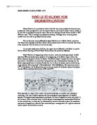
Soil exposed to sun, wind and
Deforestation rain. Nutrient cycle soil erosion.
broken.
Soil becomes useless/
exhausted.
This diagram shows what would happen if deforestation occurred.
Increasing demand for food is probably the most driving force behind over intensive land use. In the Sahel region or the whole African countries has doubled for the past years. More people mean more food. The extra food can either be produced from the same land, by intensifying production, or by agricultural extensification, using more land. Intensification can mean grazing more cattle on an area, or shortening fallow periods for fields. Extensification can mean using land that is not well-suited to agricultural use.
Over-cultivation is another form of human action that can lead desertification. It takes a number of forms. It means that pressure for ore food encourages a farmer to cut the length of time a field is left fallow after cultivation. Cultivation can be said as monoculture. It also means the cultivation of soils that are not really suitable for the growing of crop.
Over-cultivation reduces soil fertility and plant growth. Fields are often left fallow or used as pasture for several years after a period of continuous cropping. This is to allow the soil to recover its store of nutrients and rebuild its fertility and organic content that have been used by growing crops.
When a plot is not allowed to recover its fertility because fallow period are shortened, the soil becomes exhausted, losing nutrients and suffering a breakdown of soil structure. Eventually, this has the effect of reducing crop yields and plant cover, which in turn leaves soils open to the ravages of water and wind erosion, so further depleting nutrient content and soil structure.
Monoculture;
Allows growing over-used plots
the same crop
Soil exhaustion soil erosion.
The same nutrients
always taken from nutrients lost from
the soil the soil