There have been many visitors to Dunwich Heath since the National Trust has been in place there (Fig G2). This has had some bad effects as well as good which will be explained latter on in this project.
Method of Data Collection
On the visit to Dunwich Heath, five different techniques of primary data collection took place. In this section the method for each one will be explained.
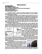
1. An Environmental Quality Analysis (EQA) was done (Fig Q1) It assesses an opinion about a place and was taken in three different places, the Heath, the Beach and facing South towards Sizewell. A different coloured circle for each site was placed around a number (1-5) that best described the feelings towards a pair of words. An example of words would be Calm and Unsettled. This shows which area is most pleasing to a person visiting. The answers were then collated in a graph. The problems a graph was then done to compare the different areas (Fig G3). The problems with an EQA is that it is one person's point of view and based on one persons opinion, if this was carried out again, an average should be taken of many peoples EQAs so it would show a more accurate view of what people thought of the area.
2. A questionnaire was asked to find out visitors views on the area and to give an idea of tourism (Fig Q2). It was asked in different places at the Heath land and coastline when ever a visitor was seen. It asked from how far away people came to the area to see if it is well known and how often they visited. All of the results were then collected together and compared with results from a previous year. If this was carried out again more options would be given as not all views were included. For example, an ‘other’ option could have been included in some questions.
3. While at Dunwich the National Trust gave us two talks, one about the heathland and the other about the coast. During this talk, notes were taken to refer to later (Fig N1, N2). The first was in the education hut which was set up by the National Trust. This talk was set up to explain the background of the area, management taking place and what the heathland was. If this talk was given again better notes would be taken as not enough information was recorded. Also, the talk could have gone into more detail about the management that took place.
4. Field sketches were drawn to show what the area looks like at present (Fig S2, S3, S4). They were later annotated to illustrate what was what and make it easier to look at. They could be redone in more detail if needed and coloured to make things clearer. Field sketches were drawn at three sites. If this was done again no changes would need to be made as the information collected was adequate.
5. Photos were also taken (Fig P1 – P11, D1, D2, D3). Digital photographs were also taken. They are easier to take then field sketches, but are harder to annotate. They work well complementing the field sketches and were used when field sketches were not appropriate, or not enough time was available. If this was done again a better selection of photos would be taken as some were irrelevant and in others, the view was obstructed. Also, more pictures could be taken to give a better view of the area. Another thing that can be done is to use the digital camera to take more pictures as they are easier to work with and can be edited in order to annotate them.
Data Presentation
Fig N1: National Trust Talk Notes on the Heathland
- National Trust bought Dunwich in 1968
- Enterprise Neptune set up by National Trust
- Dunwich included in it.
- 87 hectares Suffolk sand links Lowestoft to Ipswich
- Dunwich takes up 5%
- 1.6km of sandy cliffs at Dunwich coastline
- Soil at the Heath is ‘podsol’.
- Land used by man for resource – Cutting heather
Burning heather
Gorse for fencing/burning
Grazing – sheep
- Loss of land due to – Forestry
Urban development
Farming
Air base development – RAF
- Lost 90% of sand links over last 100 years or so
- Loss through no management
- If no management, all will turn into forests/woodlands
- 200,000 visitors per year to Dunwich Heath
- Lots of dog walkers
- This causes lost of erosion
- Don’t stick to paths so more are made which destroys the heath
- Battery powered cart for OAPs and the disabled
- Educational facilities available for the old and young
- Need good regeneration of heather
- Average erosion rate of cliffs – 1 metre per year
Fig N2: National Trust Talk Notes on the Coastline
- At the beach there are cliffs
- Chalk was made below the ground
- Movement of the earth produced mountains
- The chalk was now at the top of the mountains
- When chalk weathered, silica came through
- The silica was in the form of flint
- Over 90% of the stones on the beach are flint
- In the ice age a 3km high glaciation took place
- When it melted it swept material out to sea
- It went on for 3-5km and was 15 metre deep
- In land it went up to 50 metre deep
- The cliff have been through 3 lots of glaciations and so are flimsy and unstable
- This contributes to their easy erosion
-
Southwold had money to build sea defences
- Dunwich couldn’t
- Problems with longshore drift
- At Dunwich the harbour filled with sand
- Dunwich became very poor
- Sea walls cost £5,000 a metre
- COSTS A LOT OF MONEY
- The layers in the cliffs depend on how fast the water was going at the time.
- Scrapes encouraging birds to feed in shallow water
- Clear water separated from sea water
- Sluices built to stop water entering the marsh
- Bund, a mud heaped wall, to keep fresh water fresh
-
Bund is 3rd line of defence
- All man-made
- All is managed
Questionnaire Results
Fig G5: A pie chart showing how far away visitors live from Dunwich 2001
Fig G6: A pie chart showing how far away visitors live from Dunwich 2002
Fig G6: A pie chart showing how often visitors visit Dunwich 2001
Fig G7: A pie chart showing how often visitors visit Dunwich 2002
Fig G8: A bar chart showing what visitors like about Dunwich
Fig G10: A bar chart showing what visitors dislike about Dunwich
Fig G11: A bar chart showing who visitors think should be responsible for any sea defences at Dunwich
Fig G12: A pie chart showing if visitors think sea defences should be put up at Dunwich 2002
Fig D4: The bottom of the cliff has been fenced off to protect sand martins.
Fig D5: A sign post for a fenced off area for nesting birds telling people to stay out. Signposting is not always effective.
Fig D6: a close up of the different pebble layers in the cliffs.
Analysis of Results
The data collected needs to be put into context with the seven smaller sections that need answering. These are,
-
Where is the area?
- What is the area like at present?
-
How and why is the coastline being managed at present?
- How and why is the health land being managed at present?
- What effects does this have on the local people?
- What effects does this have on the environment?
-
How might the area be managed in the future, and with what effects?
Where is the area?
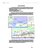
In this project, the area being studied is Dunwich Heath and Coastline. Dunwich Heath in East Anglia (Fig M1) in the county of Suffolk. It is on the coast between Southwold and Aldeburgh. (Fig M2). The Dunwich Heath Nature Reserve isn’t actually in Dunwich it is about 1.5 miles south of it (Fig M3). In the area surrounding the Heathland there is another Nature Reserve, Minsmere RSPB bird reserve (Fig M4). Dunwich Heath also has a visitor’s centre set up by the National Trust, in the old Coastguards Cottage (Fig D1) as well as an education hut (Fig P9)
What is the area like at present?
The area has many different characteristics as it has different environments in it. The first is the Heathland. The Environmental Quality Analysis shows that the Heath has the lowest score. This is shown in Fig G4 and is backed up in Fig Q1. This result would be consistent with an environment that is pleasing to be in. This is backed up by the results from the 2002 questionnaire. This showed that the majority of people, 20 in all, liked the wildlife/vegetation at Dunwich Heath (Fig G8). At the moment the heather on the Heath is being destroyed. Some of it is due to natural degradation of the heather, shown in Fig P4, but instead of it regenerating it is being invaded by other plants. The main contributors to the slow descend of heather are Scotch Pine, Birch and bracken, this invasion is can be seen in Fig P11, and is backed up in Fig P5 which shows the invasion of honeysuckle. Some of the Heath is being turned into forests and woodland which is not good as it destroys habitats. The second environment is the coastline. The Environmental Quality Analysis shows that the beach has the middle score. This is shown in Fig G4 and is backed up in Fig Q1. This would show that the environment is quite pleasing to be in. This is backed up in the questionnaire results from 2001. They show that the majority of people, 33 people, liked the Sea/Beach/Cliffs best at Dunwich.
How and why is the coastline being managed at present?
There are several management schemes in place at the coastline. The first sign of management can be seen along the entry road. Three or four speed bumps have been put in place (Fig D2). These were put there in order to slow drivers down in order to prevent road accidents that could damage the area or people. As the road is close to the cliffs, if a driver lost control of his/her car, they could go over the edge of the cliff.
How and why is the health land being managed at present?
There are several management schemes now in place at Dunwich heath there aim is to provide a suitable environment for wildlife and people
What effects does this have on the local people?
What effects does this have on the environment?
How might the area be managed in the future, and with what effects?
There are several management schemes now in place at Dunwich heath there aim is to provide a suitable environment for wildlife and people, this made difficult as in certain cases they don't work together as people make new paths to get to a different part of the heath quicker, destroying the shrubs on the way and disturbing wildlife, when another group of people then see this path thy take it as an indication that the path is meant to be there and walk down. The management make people aware of Nature sensitive areas by putting up signs such as the one shown in the photograph.
Other management schemes are - heather cutting, tree and scrub clearance, turf stripping these are types of Mechanical management
The age of heather stands can be controlled by cutting, giving an assortment in the heath land habitat, to the benefit the different ranges of heath land wildlife, which depends on different ages of heather. Regular cutting also maintains the strength of heather stands. To prevent build up of organic matter and fertility, it is necessary to collect the cut material so large scale cutting is usually by forage harvester into a trailer. A major part of heath land management for conservation is removing young trees (scrub) to prevent the heath land being lost to developing poor quality woodland. Litter or turf stripping can also be very effective way in restoring heather in areas, which have been taken over by bracken. The bare ground firstly left by the procedure can be very valuable for heath land insects such as bees and wasps.
Another management method that is carried out is Controlled burns; this consists of burning heather stands promoting their regeneration, particularly as, unlike cutting, the burning removes some of the collected organic matter under the stand. Controlled burning needs skill to achieve the best results and ensure that the fire does not get out of control. It is usually done in late winter to minimise damage to heath land wildlife. The heath land at Dunwich has gaps in it with bare soil, this acts as a firebreak and therefore if part of the heath land were on fire the whole heath land wouldn't be lost to the blaze.
At the present time Dunwich has no clear defences against long shore drift which is the main problem and can be see from the questionnaire results fig: 11 where most people said they didn't think the area was well protected, as Southold has and is stopping sand reaching Dunwich, the only problem is that Dunwich can't afford groins as they need repair work, which will cost them too much, from the questionnaire results that people believe that the national government should pay for repair of any coastal defences in the area.
Management that is in place at the coast is sign posts like the one in alerting people of the fragile cliff faces, in the future it would be suspected that more notices would be put up similar to the ones now, as the cliffs erode more. This happens at a rate of 1 metre a year the ways the cliffs are eroded by three different types of erosion, these are:
· Hydraulic pressure -This happens when the force of the waves especially when they trap and compress air in the cracks and holes in a cliff. Braking a bit of cliff off.
· Corrasion-This happens when the waves hurl particles, for example small pebbles, at cliff surfaces.
· Corrosion -This happens when certain types of cliff are slowly dissolved or decomposed by the acids in the seawater.
Destructive waves are waves that erode beaches and cliffs they are high-energy waves. They have more power and can remove the sand from a beach very quickly. The most destructive waves occur during storms.
These all take place at Dunwich and is how the cliffs are eroding. The main reason why the area needs protecting is it is home to rare species of creators, for example silver studded blue butterfly which is the rarest butterfly if the area isn't protected the wildlife would die out. Another reason why the area needs protecting is that it is visited by a lot of tourists from afar, ,also the reason why they like the area are truly unique and it would be difficult to find and area which combines a feeling of space, freshness quietness, that's natural with some cliffs, a beach with great wildlife and vegetation for a tourist.
Conclusions
Hjkhlkjh
Bibliography
Waugh, D. ‘The New Wider World’ 1998 Thomas Nelson & Sons Ltd
Acknowledgements
Representatives from The National Trust who gave talk and a tour of the area.
Mr Lister, Suffolk Coast and Heaths Countryside Officer.
Mr S. S. Stickland, Chairman, Dunwich Parish Meeting.
Appendix