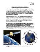
The satellites transmit radio signals, designated L1 and L2 with civilian GPS’s using the L1 frequency of 1575.42 MHz in the UHF (Ultra High Frequency) band. The satellite signals are low powered signals between 20-50 watts. There are five control stations located around the world - four “unmanned” monitoring stations and one “master” station. The four control stations constantly receive data from the satellites and send that information to the master control station, which corrects the satellite data and together with two other antennae sites sends (“uplinks”) information to GPS satellites.
The signals travel by line of sight, meaning they will pass through clouds, glass and plastic but will not travel through solid objects such as buildings and mountains. A signal contains three different bits of information- a pseudorandom code, ephemeris data and almanac data. The pseudo- code is an I.D code that identifies which satellite is transmitting information while ephemeris data contains important information about the status of the satellite (healthy/unhealthy), current data and time. This part of the signal is essential for determining a position. Almanac data shows orbital information, i.e., where the satellite should be at any time throughout the day.
Photo courtesy Garmin
The distance is measured by multiplying the length of delay of the signal from the satellite to the receiver by the speed of light (3.108 ms-1 as radio waves are part of the electromagnetic spectrum). In order to make this measurement, the receiver and satellite both require atomic clocks that have the ability to be synchronised down to the nanosecond. However this method assumes that signals will make their way through the atmosphere at a constant speed (speed of light) but this is only in a vacuum. As a GPS signal passes through the charged particles of the ionosphere and then through the water vapour in the troposphere the electromagnetic energy slows down slightly, creating delays in the signal that translate into position errors.
A GPS receiver must be locked on to the signal of at least three satellites to calculate a 2D position (latitude and longitude) and track movement. However, if four or more
satellites are in view the receiver can determine the users 3D position (latitude, longitude and altitude) with an accuracy of approximately +- 100 metres. Military versions are more accurate than civilian. Most modern receivers are parallel multi-channel designed and typically have from between five and twelve receiver circuits each devoted to one particular satellite signal so strong a lock with the satellites can be maintained at most times. Once the position is determined the users GPS unit can calculate other information such as speed, bearing, track, and trip distance and distance to destination, all of which is displayed on the units’ electronic map.
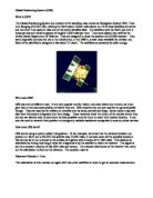
GPS Receiver with built in map for drivers. Photo courtesy Garmin
There are also other factors that degrade the GPS signal and thus affect the accuracy. Signal multipath occurs when signal is reflected off objects such as tall buildings or large rock surfaces before it reaches the receiver. This increases the travel time of the radio signal, thereby causing errors. A receiver clock error is where the receivers clock is not as accurate as the atomic clocks onboard the satellites and can cause slight timing errors. Orbital errors also known as ephemeris errors are inaccuracies of the satellites reported location. The greater the number of satellites visible for the GPS receiver, the better the accuracy. Buildings terrain, electronic interference, or sometimes even dense foliage can block signal reception, causing position errors or possibly no reading at all. GPS units typically will not work indoors, underwater or underground. Satellite geometry/shading refers to the relative position of the satellites at any given time. Ideal satellite geometry exists when the satellites are located at wide angles relative to each other.
Geoscientists are now able to input their field observations into a digital database using a palmtop computer (PDA) linked to a GPS. This called Digital Geological Mapping (DGM) an extensive research is currently taking place in this area. It can determine basin locations, architecture and dynamic evolutions of deep-sea structures. In the future this
will allow for natural resources companies, especially oil natural gas corporations, to improve prediction in exploration and characterisation of ocean structure. The structural data associated with faults, fissures and seabed deformation will be acquired using DGM via PDA’s linked to GPS that provide dm-to-cm-scale levels of accuracy. Mapping surveys such as this could permit rapid and highly accurate data collection, spatial analysis and 3-dimensional (3D) visualisation. This may also develop other technologies, which potentially can be applied to future studies of geographical hazards in both urban and rural settings.
The most common airborne applications are for navigation by general aviation and commercial aircraft. Airlines have saved millions of dollars by using GPS to hone their
flight plans while using it as a landing instrument making new air-avoidance systems possible. GPS saves fuel and extends an aircraft's range by ensuring pilots do not stray
from the most direct routes to their destinations. GPS accuracy will also allow closer aircraft separations on more direct routes, which in turn means more planes can occupy limited airspace. Civilian pilots use GPS for crop dusting, aerial photography and surveying while telecommunications companies increasingly rely on it to synchronise their land based digital networks, comparing their reference clocks directly with GPS time.
At sea, recreational boaters, commercial fisherman and professional mariners typically use GPS, locating lost vessels. Shipping companies equip their vessels with GPS for navigation and to record and control the movements of their cargo. Fisherman can also return to their best fishing locations without deviating from their indented course.
Precision timing and position information are essential to the scientific community who use the GPS to monitor earthquakes and the shifting of the earth’s tectonic plates. Hunters, snowmobiles, mountain bikers, cross country skiers and other
sportspeople employ GPS so they can pinpoint destinations and map their routs in case of an emergency such as a natural disaster. GPS is commonplace in automobiles as some basic systems are in place that provides emergency roadside assistance while more sophisticated systems that show an individual’s position on a street map are also available. These systems allow a driver to keep track of where he or she is and suggest the best route to follow to reach their designated location.
Aviation, agriculture, construction/civil engineering, marine surveying and oceanography, public safety, precision timing, recreation/gaming (such as hunting and fishing), automotive /intelligent vehicle navigation, mining and geological applications, are example of fields in which GPS has affected society’s activities. The current worldwide market for GPS receivers and technology is estimated at more than $2 billion and is expected to grow to more than $30 billion in the next ten years. GPS technology has matured into a resource that goes far beyond its original design goals. These days scientists, sportsmen, farmers, soldiers, pilots, surveyors, hikers, delivery drivers, sailors, dispatchers, lumberjacks, fire-fighters, and many other people are using GPS in ways that make their work more productive, safer, and easier.