GCSE Georgraphy Coursework: Coastlines
Introduction
For my GCSE coursework I will be looking at coasts. In order to answer this question I will be looking at why and how sea defences are being used in Norfolk Whilst investigating this question, there are a number of sub-questions which I will need to answer to help me answer my main question. These are:
> Why are the sea defences needed?
> Which defences are being used and where?
> Are they effective? Do they solve the problem?
> What are the advantages and disadvantages of the sea defences?
> What impacts do they have on the settlements/economy of the area?
History of Norfolk
Norfolk is one of the biggest counties in England, (in terms of area as it covers a little over 1.3 million acres.) It is situated on the east coast of Britain, with the North Sea to the east and north. Surrounded by three other counties, Suffolk to the south, Cambridge to the south west, and Lincolnshire to the west. The western part of Norfolk is quite flat and the southern part is known as the Norfolk Broads. While the county has no great heights, the city of Norwich and the north of the county are quite hilly. The North Norfolk coastline is designated as an Area of Outstanding Natural Beauty (AONB) and covers a stretch of approximately 75km. An average of 1m of cliff a year is lost to the sea through erosional processes, resulting in a need to protect the coastline in various ways.
We visited four different locations along the North Norfolk coast each with sea defences, these were:
> Cley-next-the-sea
> Sheringham
> West Runton
> Overstrand
Background on the four locations.
Cley next the sea
Cley is an area that has been designated a Site of Special Scientific Interest. It is also an area of outstanding natural beauty (AONB) and a specially protected area (S.P.A). Cley next the sea is so called because it used to be next to the sea. It is now 600m from the sea, the freshwater marsh is now between, due to the river Glaven. The marsh is very important as it is a special habitat for flora (plants) and forna (animals) and needs protecting from the sea salt water. In 1953 the marsh was flooded and again in 1996 and this killed all the plants. It took four years to get it back to a fresh water marshland. There are 100 species of birds here during most months and 200 who migrate to Cley in the summer. The fresh water marsh is protected by the Cley ridge in the middle of the shingle ridge and it costs £40,000 each year to push all the shingle off the beach to form the ridge. It is 1.5 miles long and goes all the way to Weyborne.
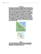
Sheringham
Sheringham is the second biggest cliff top settlement on the North Norfolk coast. There are approximately 7,200 people
and there are 120,000 visitors a year making it a popular tourist town. In the 1890's it was said that £18,000 was spent on sea defences including a sea wall and the locally famous Uponer groyne- made from oak from a local woodland. This groyne had removable planks for when the beach had built up. This was to allow further sediment transport. Increasing coastal protection measures became effective in Sheringham. However successful they were, the promenade juts out 70 metres from the surrounding coastline. This exposed position leads to greater scouring from wave action. The Sea wall also serves a purpose as a promenade. It is made out of natural materials, it looks good and allows people to walk along the beach front. There are also groynes that keep the material by the sea wall and also form into rip rap, called rock armour groynes. After the storms of 1993 Sheringham had to look at major plans for the future. The plan had to consider three key issues
> Reduce erosion rates and flood damage
> Enhance the amenity value of the town's beaches
> Make the area environmentally sound and have no adverse effect on neighbouring coasts and beaches.
Again in 1993 in order to enforce these issues, all the sea defences were reinforced and the sea wall was extended costing £5.2 million. There is a natural sandbank which splits the longshore drift in two directions- east and west. The winds tend to come from the north, mainly from the North Sea. During the summer, when the weather is finer, the materials are brought in. In Sheringham the purpose of sea defences are to maintain the beach for tourism. Recent schemes in Sheringham have cost a total of £7,936,840 and have included sea walls, revetments, groynes, gabions, rip rap, bore hole and a beach recharge.
This picture shows Sheringham Beach, to the left is the groyne, in the centre is the sea wall/ promenade.
West Runton
West Runton is a small, quiet village on the North Norfolk Coast close to Sheringham, with a population of 1,600. After the storms in December 1990 remains of a 6-700,000 year old elephant were unearthed. Now commonly referred to as the West Runton Elephant, ribs, jaw, backbone and part of a leg were found in January 1990 and in 1995 the major excavation work was carried out to recover the rest of the skeleton. This skeleton is said to be the biggest, most complete and best preserved elephant skeleton ever found. So the defences protect this cliff. There is managed retreat to the west. To the east there is no management allowing longshore drift to move sediment to Cromer. The sea wall protects the slipway to allow boats out. At the base of the sea wall there are revetments. The different defences being used here include; groynes, sea walls, gabions and revetments.
Overstrand (Clifton way)
Overstrand is a small village with housing at the top of the cliff. There are approximately 1,100 people living in Overstrand which is situated on 35 metre high cliffs on the North Norfolk coast. It is important to protect this settlement as peoples houses are at a risk. The total costs of work at Overstrand has come to £1.75 million.
There is a long history of cliff failure and coastal erosion here at Overstrand. The need for a coastal protection scheme at Clifton Way followed a series of cliff failures. The first ...
This is a preview of the whole essay
Overstrand (Clifton way)
Overstrand is a small village with housing at the top of the cliff. There are approximately 1,100 people living in Overstrand which is situated on 35 metre high cliffs on the North Norfolk coast. It is important to protect this settlement as peoples houses are at a risk. The total costs of work at Overstrand has come to £1.75 million.
There is a long history of cliff failure and coastal erosion here at Overstrand. The need for a coastal protection scheme at Clifton Way followed a series of cliff failures. The first occurred in May 1990, where 40metres of land was lost to the sea. This was followed by further failures in November 1992, where 20metres of land was lost. Then in January 1994, another 25metres was lost. This last failure severed the 225mm diameter public sewer serving 60 houses and placed the village school dangerously close to the cliff edge. Approximately 85-90 metres of land was lost as a result of the failures and further failures were expected if no works were implemented. Indeed another 20 metres were lost immediately prior to works starting in March 1995. By this stage the eroding cliff edge was only 5 metres away from the roadway and another failure would have led to the loss of the road and services and the properties they served would have been declared unsuitable for habitation.
Overstrand was turned into an experimental site for sea defences because it is not a major area and has little tourism. At the western edge of Overstrand there is a length of timber revetment and a short section of block revetment before the start of the Seawall, promenade and groyne system that stretches eastwards for about 600 metres along the frontage. The defence then becomes a timber revetment once more.
The beaches at Overstrand are generally low, exposing the steel sheet piled foundations of both the walls and the revetments. The defences in general are showing signs of ageing and it is expected that major repair works will be needed in the near future. Ground water leaking through the cliffs is a considerable problem at Overstrand and a number of cliff drains and boreholes exist to try to reduce the erosion this causes. The use of a gabion embankment behind the promenade and retaining wall has proved effective in stabilising one section of the cliffs. Following the cliff failure at Clifton Way in May 1990, work was undertaken to stabilise the site. As a result, surface and sub-surface drains were constructed and a large amount of rock armour was used to hold them in place. When the channels were first put in, they were put in the wrong places.
All the slumped material on the beach is taken away mixed up and put back in the same place, but in a much smaller gradient. Glacial till and gravel was mixed up to create the smaller gradient. This rock is clearly visible behind the revetment to the east of Overstrand. Vegetation was added to the soil at Clifton Way, but the shrubs died due to the bad soil condition.
This area is constantly monitored for slumping so they can try and predict when a slump will occur. They have also incorporated a road as access for primary industry (fishing) use. Unfortunately the latest slump has blocked this road.
Methodology
Beach profile
This was used to compare the gradient of managed and unmanaged beaches. We did the beach profiles on constructive and destructive beaches. A constructive wave is a long low wave which carries material up the beach, making it steeper. A destructive wave is a steep, high wave, making the backwash more effective so material is removed to an offshore bar. Beginning where the waves break, a ranging pole is held upright at this point. Another ranging pole is placed 10m up the beach or where the next change in angle occurs. The gradient of the beach is measured with a clinometer. The clinometer is placed on the highest divide between the red and white bands on the first ranging pole. Looking through the clinometer and matching it up with the red and white on the other pole the measurement can now be read and recorded on the record sheet (in degrees.)
Limitations
It was windy making it hard to read the clinometer and keep it steady, also it was hard to hold the poles steady. Some of the beaches weren't very flat and had a lot of changes in angle.
Pebble analysis
We picked up a handful of stones at different points on the beach for Sheringham and Cley next the sea. We picked up a handful of pebbles, then again re-picked ten big and small pebbles. Using a pair of callipers we measured them at their longest axis, and each stone was compared and given a class number for how round or jagged it was and this was all recorded in the table below.
Limitations
Unfortunately we were unable to do all of Sheringham beach and only managed to measure the top third of the beach. Apart from that there weren't really any limitations with this.
Environment Quality Index (E.Q.I)
For each beach, we answered sub questions on human intervention, effect of management on coastal properties and infrastructure, effect of management on primary industry, aesthetic value, access, effect of management on areas along the coast, we scored each one out of 10, ten as highest and one as lowest.
Limitations
There are no limitations really because there are no right or wrong answers.
Groyne measurements
Beginning where the waves break on to the beach place a ranging pole on top of the groyne so that half the ranging pole sticks out either side of the groyne. We measure the distance between the end of the ranging pole and the beach surface on both sides of the groyne then we recorded the result. We did this at regular intervals up the beach.
Sea defences
There are six main types of sea defences used in Norfolk, these are;
Type: Seawall
Description: Concrete wall of different designs; can include flat decks for walking or car parking.
Average cost: £3000-4000/m
Effects: Deflects wave energy into the next wave movement.
Advantages: Capable of withstanding high energy waves. Efficient and effective. Strength and height reassures public fear of flooding.
Disadvantages: High cost of building and repair. Reflection can cause turbulence and scouring of the beach. Not very attractive. Makes access to the beach difficult.
Used: In Sheringham, Overstrand and West Runton
Type: Rip-Rap
Description: A jumble barrier of large, irregularly shaped rocks or concrete.
Average cost: £3000/m
Effects: Absorbs wave energy in gaps and voids between the boulders.
Advantages: Very efficient and relatively cheap.
Disadvantages: Cost rises if rock is imported. Must be large enough to remain stable (3 tonnes). Difficult access to the beach and dangerous for young children.
Used: In Sheringham, West Runton.
Type: Gabions
Description: strong wire baskets filled with stone and rubble. Often used to protect sand dunes.
Average cost: £100/m
Effects: Gaps between stones absorb wave energy.
Advantages: Trap sand, often become covered with vegetation. Visually less obtrusive.
Disadvantages: Not as effective as a sea wall. Shorter life span if exposed.
Used: In Overstrand, West Runton
Type: Groynes
Description: Low walls of timber or concrete built at right angles across the beach.
Average cost: £7000 each
Effects: Traps sand moving along the beach by longshore drift. Beach built up between the groynes are able to absorb more wave energy.
Advantages: cheaper than sea walls. Maintains beach for tourists. No problem of access.
Disadvantages: beaches further along the coast maybe starved of a supply of sand and become more vulnerable.
Used: In Sheringham, Overstrand and West Runton
Type: Revetments
Description: low slopping walls of concrete built at the top of the beach.
Average cost: £2000/m
Effects: reflects and absorbs wave energy.
Advantages: beach scouring is less than with a sea wall. Relatively cheap form of 'hard' defence. Less intrusive than a sea wall.
Disadvantages: unsuitable for high energy conditions. Short life span.
Used: In West Runton and Sheringham
Type: Beach nourishment
Description: Beach made higher and wider by feeding sand and shingle brought in by lorries or dredgers. Often used to 'protect' hard defences.
Average cost: £20/cu.m
Effect: Beach more able to absorb wave energy, particularly in storm conditions.
Advantages: Very effective. Relatively cheap. Maintains natural appearance of coast. Preserves a beach for leisure purposes.
Disadvantages: Beaches probably need to be re-nourished if storms cause erosion, increasing the cost. Offshore dredging may increase erosion in another location.
Used: In Cley-Next-The-Sea
Analysis
Groyne Measurements
Sheringham
Sediment build up is generally greatest on the eastern side. This is due to Longshore Drift operating mainly from east to west (The sediment is being transported along the beach). The groynes have been effective in trapping the sediment and keeping the beach at Sheringham.
West Runton
This graph shows that sediment build up is generally greater on the western side of the groyne, although there is a greater build up of sediment of the eastern side at 15-25m. This is due to the fact that longshore drift is operating from west to east. Longshore drift being the movement of sediment along a beach. So the groynes have been effective in trapping the sediment and keeping the beach at West Runton.
Beach Profile
Cley (managed)
Relatively steep beach profile. This is an artificial area of beach where sediment (shingle) has been brought in to protect the freshwater marsh behind. The beach is reshaped by bulldozers.
Cley (unmanaged)
Relatively flat beach profile. This is Cley beach without the artificial sediment brought in. The beach is mainly just flat as long shore drift takes place without the sediment being replaced.
Overstrand
Relatively steep in places with sloping occurring in places.
Sheringham
This beach profile shows a small increase with relatively flat middle part, but then it becomes quite steep towards the sea wall and then decreases dramatically to the edge if the sea wall.
ENVIRONMENTAL QUALITY INDEX (E.Q.I)
Human Intervention
All sites show evidence of human intervention but more so at Cley, Sheringham and West Runton, as their area of coastline is constantly under threat of being eroded away, it is important to protect the coastline and this has been possible through human intervention.
Effect of management on coastal properties and infrastructure
All the four locations scored quite high meaning the management of coastal properties are more positive than negative. Sheringham and West Runton both scored 9/10, Overstrand Clifton Way scored 8/20 an both Overstrand beach and Cley Next The Sea scored 7/10.
Effect of management on Primary Industry
Again the four locations scored quite high making the overall management on primary industry positive. Sheringham scored a 9/10 because it was the best managed for primary industry. Cley Next The Sea, West Runton and Overstrand all scored 8/10 because even though they have the most Sea defences they also had a good effect of management on primary industry. Overstrand Beach scored the lowest with 7/10 though that is still nearer to positive than negative.
Aesthetic Value
Unfortunately the results for this category weren't as high and were quite low, near to the ugly part. This is mostly due to the fact that either a lot of concrete is used or there is a lot of damage to the sea defences. Although Sheringham scored 10/10 because it does have a very good aesthetic value and the beach has tried to be kept as natural as possible, so can be enjoyed by the many tourists that visit it.
Access
Most of the four locations scored well in this section. Access to all the locations weren't brilliant and on Overstrand beach you couldn't really get on to the beach. Cley Next The Sea scored the lowest with 5/10 as it was a steep climb to get up on to the shingle ridge and there was only a small car park area, with a small entrance. Overstrand Beach scored 6/10 because there was a lot of sea defences with no easy way of getting on to the beach. West Runton scored 7/10 because there was quite good access but a really steep drop to get onto the sea wall, but there was good access down to the beach, but further along there were a lot of revetments where access to the beach was blocked off. Both Sheringham and Overstrand Clifton Way scored 8/10, Sheringham had quite good access to the beach although there were old steeps that were dangerous and crumbling. Overstrand Clifton way had a good access slip road recently built which gave good access to it but the cliff had collapsed blocking the road whilst we were there.
Effect of management on areas along the coast
Most of the Locations scored good marks, as they were nearer to the positive side and not the negative. Sheringham and Overstrand Clifton Way scored the most with 8/10, West Runton with 7/10, Overstrand Beach with 6/10 and Cley Next The Sea with 5/10.
Sustainability test
To summarise all the results of the sustainability test I will use the 4 different question headings.
. Are the natural processes taken into account?
a) Is the beach being replenished? If so is the replenishment natural or man made?
b) Is sediment being transported along the coast by longshore drift?
> Cley- The beach is being replenished and it is natural as it's pushed up from the beach by bulldozers. Sediment is being transported by longshore drift towards Cromer.
> Sheringham- The beach is being replenished and it is natural, as it's brought in from surrounding areas. Sediment isn't being transported along the beach by longshore drift because the groynes are stopping it.
> West Runton - The beach is being replenished but it is man made. Sediment is not being moved by longshore drift because the groynes are stopping it.
> Overstrand- The beach is being replenished by man made materials.. The sediment is not being moved by long shore drift as the groynes are stopping it.
2. Is the character of the landscape maintained?
For all locations the character of the landscape is maintained as materials used are natural materials and keep the aesthetic value of the beach, retaining it for tourism.
3. Are important habitats and wildlife protected?
Yes, For all locations habitats ad wildlife is protected, especially at Cley where the wildlife is more constant.
4. Are the settlements protected?
Yes, the settlements have been protected, especially at Overstrand (Clifton Way) as the defences there have protected the local school from reaching dangerously close to the cliff, and also at Sheringham where the population is higher than that of the other three locations.
Pebble Analysis
Cley
Bottom
Average roundness 3.7 most stones are sub angular to sub rounded.
Average size 18.9
Pebbles have been eroded by the action of the waves. This is mainly due to attrition, where the material being moved by longshore drift is constantly colliding, knocking pieces of making them smaller and rounder. Also due to abrasion, where the stones are carried in the water and then hurled at the shoreline when a wave crashes on to the beach. The pebbles collide with the shoreline, knocking pieces off which are then carried away by the sea.
Middle
Average roundness 3.7 most stones are sub angular to sub rounded.
Average size 14.68
These stones have been artificially placed by the creation of the shingle ridge.
Top
Average roundness 3 most stones are sub angular
Average size 18.9
These stones have also been artificially placed because it is the bottom of the shingle ridge and also far enough away from the sea and shore, so erosion of the stones can't take place.
Sheringham
Top
Average roundness 4.5 most stones are sub rounded to rounded
Average size 48.7
These stones are quite big as they start off as big stones which are then broken by erosion and smoothed down hen left at the top of the beach only really touched again when the tide comes in.
Conclusion
My aim of this project was:
Why and How are sea defences being use in Norfolk?
In order to answer this question I had five sub question to answer as well. These were:
Why are the sea defences needed?
The sea defences are needed because the coast around Norfolk needs protecting from the erosion caused by the sea. Every year metres of coast is lost to the sea, causing damage to the settlements and features of Norfolk, if nothing is done about this increasing problem the land will all be lost to the sea.
Which defences are being used and where?
The defences being used are:
> Groynes
> Revetments
> Rip-Rap
> Sea Walls
> Shingle Ridge
> Gabion Cages
These are used in;
Groynes-Sheringham, Overstrand and West Runton
Revetments-West Runton and Sheringham
Rip-Rap- West Runton and Sheringham
Sea Wall- Overstrand, West Runton and Sheringham
Shingle Ridge- Cley Next The Sea
Gabion cages- Overstrand and West Runton
Are they effective? Do they solve the problem?
I found that the these defences are effective in stopping more erosion of the cliffs although they do require regular maintenance. They don't solve the problem completely and if the sea defences were left without maintenance they to would eventually be eroded and the damage to the cliffs would still happen.
What are the advantages and disadvantages of the sea defences?
Advantages:
> They protect the settlements and make house prices rise again
> They stop more of the Norfolk coastline falling to the sea
> They make people less worried as there are visual signs that something is being done.
Disadvantages:
> They make the coastline look ugly
> They make access to beaches difficult
> They are quite expensive and require repair quite regularly
What impacts do they have on the settlements/economy of the area?
The erosion of the sea means that land will fall and as more land falls, the closer settlements get to the edge. This makes house prices fall and home insurance impossible. With the sea defences in place, some settlements have a chance to either move or be kept further away from the edge for longer and sometimes insurance is possible. Obviously the sea defences cost money to be built and maintained so it does have a big impact on the economy of the area as more money is needed to keep the defences in working order.
My main question was
Why and How are sea defences being used in Norfolk?
Sea defences are being use in Norfolk to protect the coastline that's falling into the sea, taking metres of land with it and putting settlements, habitats and wildlife at risk. Also it is effecting the amount of tourism coming to the area of Norfolk. The sea defences being used are actually effective in stopping more coastal erosion from happening. The defences do this by stopping the sea from either reaching the coast or by breaking up the force of the waves before they get to the coast, this way the amount of erosion is less. To get sea defences a site must fulfil at least some of the requirements.
In overall conclusion I would say that the sea defences at Norfolk have helped considerable in stopping more of the coastline disappearing and from putting at risks the lives of people and the cliff top settlements. Although the defences can be expensive and do need constant checking and repair to keep them in good conditions to withstand the strong wave destruction.